Sabarmati River
| Sabarmati River | |
| River | |
| Country | India |
|---|---|
| States | Gujarat, Rajasthan |
| Tributaries | |
| - left | Wakal river, Sei Nadi, Harnav River, Hathmati River, Watrak River, Madhumati River. |
| Cities | Ahmedabad, Gandhinagar |
| Source | Dhebar lake, Rajasthan |
| - location | Aravalli Range, Udaipur District, Rajasthan, India |
| - elevation | 782 m (2,566 ft) |
| Mouth | |
| - location | Gulf of Khambhat, Gujarat, India |
| Length | 371 km (231 mi) |
| Discharge | |
| - average | 120 m3/s (4,238 cu ft/s) [1] |
| Discharge elsewhere (average) | |
| - Ahmedabad | 33 m3/s (1,165 cu ft/s) [2] |
The Sabarmati river is one of the major west-flowing rivers in India.[3] It originates in the Aravalli Range of the Udaipur District of Rajasthan and meets the Gulf of Cambay of Arabian Sea after travelling 371 km in a south-westerly direction across Rajasthan and Gujarat.[3] 48 km of the river length is in Rajasthan, while 323 km is in Gujarat.[3]
Basin
The Sabarmati basin has a maximum length of 300 km. and maximum width of 105 km. The total catchment area of the basin is 21674 km2 out of which, 4124 km2 lies in Rajasthan State and the remaining 18550 km2 in Gujarat.[4]
Sabarmati river basin is situated in the mid-southern part of Rajasthan. To its east lie the Banas and Mahi Basins, to its north the Luni Basin and to its west the West Banas Basin. Its southern boundary is the border with Gujarat State. The Sabarmati river basin extends over parts of Udaipur, Sirohi, Pali and Dungarpur Districts. Orthographically, the western part of the Basin is marked by hilly terrain belonging to the Aravalli Range. East of the hills lies a narrow alluvial plain with a gentle eastward slope.[4]
The major tributaries are the Sei, Wakal, Watrak, Shedhi, Harnav, Guhai, Hathmati, Khari, Meshwo, Mazam and Mohar.[3][4] Average annual water availability in the Sabarmati basin is 308 m3/capita, which is significantly lower than the national average of 1545 m3/capita.[5]
History
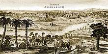
The origin legend is that Shiva brought the goddess Ganga to Gujarat and that caused the Sabarmati to come into being.[6] The ancient name of sabarmati river is Bhogwa. Ahmedabad and Gandhinagar, the commercial and political capitals of Gujarat respectively, were established on the banks of Sabarmati river. The legend is that Sultan Ahmed Shah of Gujarat, resting on the bank of Sabarmati, was inspired by the courage of a rabbit chasing a dog to the extent of establishing Ahmedabad in 1411. The soils of the Sabarmati area on the banks of the river are rich.
During India's independence struggle, Mahatma Gandhi established Sabarmati Ashram as his home on the banks of this river.[7]
The National Water Quality Programme led by Central Pollution Control Board (CPCB) positions Sabarmati River as one of the most polluted rivers in India.[8]
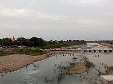
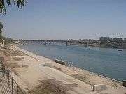
Sabarmati Riverfront
Dams
There are several reservoirs on Sabarmati and its tributaries. The Dharoi dam is located on the main river. Hathmati dam, Harnav dam and Guhai dam are located on the tributaries meeting the main river upstream of Ahmedabad while Meshvo reservoir, Meshvo pick-up weir, Mazam dam and Watrak dam are located on tributaries meeting downstream. The Kalpasar is planned project in the Gulf of Khambhat.
Dharoi Dam
The area covering upper sub-basin and the catchment of the main river up to Dharoi dam is designated as Dharoi sub-basin. Constructed in 1978, Dharoi dam is located about 165 km upstream Ahmedabad in village Dharoi of Mehsana district. This covers drainage area of the main river up to Dharoi dam. Catchment area of the sub basin is 5540 km2, out of which about 2,640 km2 lies in Gujarat state.
Gallery
See also
References
- ↑ Kumar, Rakesh; Singh, R.D.; Sharma, K.D. (10 September 2005). "Water Resources of India" (PDF). Current Science. Bangalore: Current Science Association. 89 (5): 794–811. Retrieved 13 October 2013.
- ↑ "Sabarmati Basin Station: Ahmedabad". UNH/GRDC. Archived from the original on 4 October 2013.
- 1 2 3 4 Water Year Book 2011-12: Mahi, Sabarmati & Other West Flowing Rivers (PDF). Gandhinagar: Central Water Commission. 2012. p. 14.
- 1 2 3 "Sabarmati River, INDIA". National River Conservation Directorate.
- ↑ Integrated Hydrological Data Book (PDF). New Delhi: Central Water Commission. 2016. p. 1.
- ↑ "The sacrificial maiden river". The Times of India. 2 September 2002. Archived from the original on 19 April 2015.
- ↑ "Sabarmati Ashram History".
- ↑ River pollution plaguing Gujarat
External links
| Wikimedia Commons has media related to Sabarmati River. |
- Sabarmati Basin (Department of Irrigation, Government of Rajasthan)
- Sustainable water project Sabarmati River Basin
- Map of Sabarmati Basin
- Integrated management of the Sabarmati river basin
- Information about sabarmati riverfront project of Ahmedabad
Coordinates: 22°18′N 72°22′E / 22.300°N 72.367°E
| Authority control |
|---|