List of national parks of Pakistan
Pakistan has 29 protected areas known as national parks (Urdu: پاکستان کی ملی باغ). As of 2012, 22 of these are under supervision of respective provincial governments and remaining are in private care.[1] Only some of these are under the conservation scope of IUCN. Protection and conservation of the environment of Pakistan was included in the concurrent constitution of 1973. As a result, Environment Protection Ordinance was enacted in 1983, which was mainly regulated by the Environment and Urban Affairs Division. Later, a new system of 'Modern Protected Areas' legislation began at the provincial level which assigned the protected areas with designations such as national parks, wildlife sanctuaries and game reserves. Further recommendations of the national parks of the Indomalaya ecozone were highlighted in the IUCN review of 1986.[2] Nevertheless, the development of national parks was mainly carried out by National Conservation Strategy of 1992. Due to more awareness about their importance in conservation of biodiversity, 10 national parks have been established during the time period from 1993 to 2005.[1]
According to the 'Modern Protected Areas' legislation, a national park is a protected area set aside by the government for the protection and conservation of its outstanding scenery and wildlife in a natural state. It is accessible to public for research, education and recreation. In order to promote public use, construction of roads and rest houses is permitted. Use of firearms, polluting water, cleaning of land for cultivation, destruction of wildlife is banned in these areas.[3] The oldest national park is Lal Suhanra in Bahawalpur District, established in 1972.[4] It is also the only biosphere reserve of Pakistan. Lal Suhanra is the only national park established before the independence of the nation in August 1947. The main purpose of this area was to protect the wildlife of Cholistan Desert.[3] Central Karakoram in Gilgit Baltistan is currently the largest national park in the country, spanning over a total approximate area of 1,390,100 hectares (3,435,011.9 acres). The smallest national park is the Ayub, covering a total approximate area of 931 hectares (2,300.6 acres).
 1 2 3 4 5 6 7 8 9 10 11 12 13 14 15 16 17 18 19 20 21 22 23 24 25 26 27 28 |
|
National parks
Pictures
| Wikimedia Commons has media related to National parks of Pakistan. |
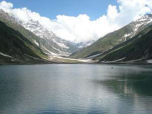
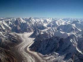 Baltoro glacier is found in Central Karakoram National Park
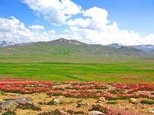 Plain of Deosai National Park
 Mud volcano in Hingol National Park
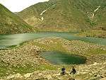
.jpg)
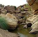 Cold water spring of Kirthar National Park
References
- 1 2 3 4 5 6 7 8 9 10 11 12 13 14 15 16 "Review of 'Protected Areas System' in Pakistan: Present status and problems concerning future development (Page 8, 9, 15)" (PDF). dergiler.ankara.edu.tr. Ankara University. 2010. Retrieved September 8, 2010.
- ↑ "Pakistan Protected Areas: Meeting Proceedings" (PDF). iucn.pk. IUCN, Pakistan. 1994. Retrieved September 29, 2010.
- 1 2 3 4 5 6 7 8 9 10 11 12 13 14 15 16 17 18 19 20 21 "Country Report on Plant Genetic Resources for Food and Agriculture – Pakistan" (PDF). parc.gov.pk. Pakistan Agricultural Research Council. Archived from the original (PDF) on January 18, 2012. Retrieved September 8, 2010.
- 1 2 3 4 "Canadian Journal of Pure and Applied Sciences, an international journal: Current issue (Number: 4, Volume: 2, June 2010) Online ISSN 1920-3853" (PDF). cjpas.net. SENRA Academic Publishers, Burnaby, British Columbia. 2010. Archived from the original (PDF) on June 16, 2011. Retrieved September 8, 2010.
- ↑ "Ayub National Park". wdpa.org. World Database on protected Areas. Archived from the original on May 22, 2012. Retrieved September 8, 2010.
- ↑ "Improving Sub-Watershed Management and Environmental Awareness in the Ayubia National Park". wwf.panda.org. WWF -Pakistan.
- 1 2 3 4 5 6 7 "List of National Parks in Pakistan". pakwildlife.org. Retrieved December 7, 2012.
- 1 2 3 4 "Protected areas of AJK". forest.ajk.gov.pk. Government of Azad and Jammu Kashmir. 2009. Archived from the original on September 21, 2010. Retrieved September 7, 2010.
- ↑ "(Fourth national report) Biodiversity of Pakistan: Status trends and threats" (PDF). cbd.int. Convention on Biological Diversity, International. Retrieved September 8, 2010.
- ↑ "Musk Deer National Park, Guraiz (MDNPG) conflict: Who is responsible?". kashmirnewswatch.com. Kashmir News Watch. Archived from the original on April 15, 2011. Retrieved September 8, 2010.
- ↑ "K2 National Park". wdpa.org. World Database on protected Areas. Retrieved September 8, 2010.
- ↑ "List of National Parks of Pakistan". pakwildlife.org. Retrieved January 16, 2012.
- ↑ "National Assembly Secretariat - "Questions for oral answers and their replies"" (PDF). cybervision.com. April 20, 2011. p. 26. Retrieved December 7, 2012.
External links
- 29 Most Amazing National Parks of Pakistan -= Manhoos
| |||||||||||||||||||
| |||||||||||||||||||
| |||||||||||||||||||
| |||||||||||||||||||
| |||||||||||||||||||
| |||||||||||||||||||
List of national parks of Asia | |
|---|---|
| Sovereign states |
|
| States with limited recognition |
|
| Dependencies and other territories |
|
| |