Fairy Meadows
| Fairy Meadows فیری میڈوز | |
|---|---|
 Nanga Parbat from Fairy Meadows | |
 Location | |
| Location | Gilgit-Baltistan, Pakistan |
| Nearest city | Chilas |
| Coordinates | 35°23′12.67″N 74°35′02.98″E / 35.3868528°N 74.5841611°ECoordinates: 35°23′12.67″N 74°35′02.98″E / 35.3868528°N 74.5841611°E |
| Established | 1995 |
| Governing body | Government of Gilgit-Baltistan |
Fairy Meadows (Urdu: فیری میڈوز), named by German climbers (German Märchenwiese, “fairy tale meadows”)[1][2] and locally known as Joot,[3] is a grassland near one of the base camp sites of the Nanga Parbat, located in Diamer District, Gilgit-Baltistan, Pakistan.[4] At an altitude of about 3,300 meters above the sea level, it serves as the launching point for trekkers summiting on the Rakhiot face of the Nanga Parbat.[4][5] In 1995, the Government of Pakistan declared Fairy Meadows a National Park.[6][7]
Location
Fairy Meadows is approachable by a twelve kilometer-long jeepable trek starting from Raikhot bridge on Karakoram Highway to the village Tato.[5][8][9] Further from Tato, it takes about three to four hours hiking by a five kilometer trek to Fairy Meadows.[8][9] The grassland is located in the Raikhot valley, at one end of the Raikhot glacier which originates from the Nanga Parbat and feeds a stream that finally falls in the River Indus.[2] Since 1992, locals have operated camping sites in the area.[10]
Tourism
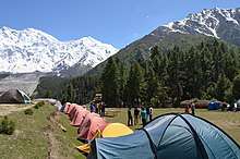
The six-month tourist season at Fairy Meadows starts in April and continues until the end of September. Tourists lodge at the camping site spread over 800 hectares (2 acres), known as "Raikot Serai".[2] The site of Fairy Meadows, though partially developed, generates about PKR 17 million revenue from tourism, mainly by providing food, transportation and accommodation services.[9] A project by Shangrila Resorts, the pioneers of tourism development in Gilgit Baltistan, will establish an eco-friendly resort. The road to Fairy Meadows was built by Brigadier M. Aslam Khan (M.C, H.J, F.K), First Commander Gilgit Scouts, which today employs the locals. The local community stopped the extraction of timber to conserve the forest and promote tourism in the area. The main attraction of this place other than the meadows itself is the view of Mighty Nanga Parbat Mountain. Tourists usually hike to the base camp of the mountain from Fairy Meadows.[9]
Flora and fauna
The grassland is surrounded by thick alpine forest.[11] The high altitude area and north-facing slopes mostly consist of coniferous forest having Pinus wallichiana, Picea smithiana and Abies pindrow trees, while in the high altitude areas with little sunlight are birch and willow dwarf shrubs. The southern slopes are concentrated with juniper and scrubs, namely Juniperus excelsa and J. turkesticana. In the low altitudes, the major plant found is Artemisia, with yellow ash, stone oaks and Pinus gerardiana spread among it.[2] Research has suggested similarities between Pinus wallichiana found in the meadows with a sister species, Pinus peuce, found in the Balkans, based on leaf size.[12]
Among mammals, a few brown bears are found in the region, with their numbers declining.[13] Some musk deer, regarded as an endangered species, are also present.[14]
Gallery
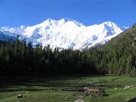 Fairy Meadows (Nanga Parbat in background)
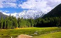 A sunny day at Fairy Meadows
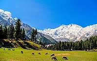 Sheep grazing at Fairy Meadow
 A Polo Match at Fairy Meadows
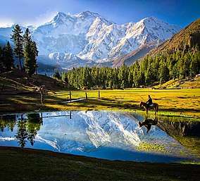
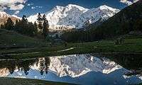 A reflection of Killer Mountain Nanga Parbat in a small lake in morning
.jpg) A full view of Nanga Parbat behind Fairy Meadows
A full view of Nanga Parbat behind Fairy Meadows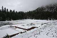 Snowfall at Fairy Meadows
References
- ↑ Timo Frasch (15 July 2009). "Nanga Parbat: Eine Blume für Karl". Frankfurter Allgemeine. Retrieved 5 October 2013.
- 1 2 3 4 Shaheen Rafi Khan (1997). Micro Case Study and Action Plan for Fairy Meadows (PDF) (Report). International Center for Integrated Mountain Development. ISSN 1024-7564. Retrieved 30 August 2013.
- ↑ Zofeen T. Ebrahim (July 2011). "Trekking to tranquility" (PDF). Pakistan Wildlife News. Bioresource Research Center. 3 (7): 7. ISSN 2077-9305. Retrieved 30 August 2013.
- 1 2 Zofeen T. Ebrahim (8 July 2011). "Trekking to tranquility". Dawn. Retrieved 24 August 2013.
- 1 2 "Roof of the World beckons trekkers". New Straits Times. 23 March 1997. pp. 32–34. Retrieved 24 August 2013.
- ↑ Lawrence S. Hamilton (15 June 1995). "New Parks for Pakistan" (PDF). Mountain Protected Areas Update. International Union for Conservation of Nature. p. 3. Retrieved 28 August 2013.
- ↑ Kanak Mani Dixit (March–April 1995). "Objects of Desire in the Northern Areas". Himal Southasian. Nepal: Himal Association. 8 (2). ISSN 1012-9804.
- 1 2 Danial Shah (28 July 2013). "Over the top: Misreporting on location of Nanga Parbat attack". The Express Tribune. Retrieved 26 August 2013.
- 1 2 3 4 Vaqar Zakaria (December 2009). Central Karakoram Conservation Complex (PDF) (Report). International Union for Conservation of Nature. pp. 21, 27. Retrieved 28 August 2013.
- ↑ Jurgen Clemens; Marcus Nusser (1 December 2000). "Pastoral Management Strategies in Transition". In Eckart Ehlers, Herrmann Kreutzmann. High Mountain Pastoralism in Northern Pakistan. Franz Steiner Verlag. pp. 168–169, 186. ISBN 978-3515076623.
- ↑ Syagfiqah Omar (22 June 2011). "Postcards from Pakistan: Karakoram and beyond". Dawn. Retrieved 26 August 2013.
- ↑ Businský, Roman (25 August 2004). "A Revision of the Asian Pinus Subsection Strobus (Pinaceae)". Willdenowia. Berlin: Botanischer Garten und Botanisches Museum. 34 (1): 248. doi:10.3372/wi34.34120. ISSN 0511-9618. JSTOR 3997476.
- ↑ Nawaz, Muhammad Ali (2007). "Status of the Brown Bear in Pakistan". Ursus. International Association for Bear Research and Management. 18 (1): 89–100. doi:10.2192/1537-6176(2007)18[89:sotbbi]2.0.co;2. ISSN 1537-6176. JSTOR 20204071.
- ↑ Participants of Conservation Assessment; Management Plan Workshop (22 August 2013). Kashif M. Sheikh, Sanjay Molur, eds. Status and Red List of Pakistan's Mammals (PDF) (Report). International Union for Conservation of Nature. p. 62. Retrieved 30 August 2013.