Extreme points of Pakistan

K2
Baba Ghundi Chipursan
Sir Creek
Gyong La pass
Pakistan, Iran & Afghanistan tripoint
Extreme points of Pakistan
This is a list of the extreme points of Pakistan.
Extreme points
| Heading | Location | Administrative entity | Bordering entity | Coordinates[nb 1] |
|---|---|---|---|---|
| North (disputed, administered) |
Baba Ghundi Chipursan west of the Khunjerab Pass |
Gilgit–Baltistan | Xinjiang, People's Republic of China | 37°05′01″N 74°41′26″E / 37.0837°N 74.6906°E |
| South | Keti Bunder South Wildlife Sanctuary, South Island near Sir Creek, Thatta |
Sindh | Arabian Sea | 23°42′59″N 68°09′49″E / 23.7164°N 68.1636°E |
| East (disputed, administered) |
near Gyong La, AGPL | Gilgit–Baltistan | Jammu and Kashmir, India | 35°03′54″N 77°07′13″E / 35.0651°N 77.1202°E |
| West | The point where Pakistan, Iran and Afghanistan meet in Balochistan, near Maki. | Balochistan | Iran & Afghanistan | 29°51′31″N 60°52′29″E / 29.8585°N 60.8746°E |
Extreme altitude
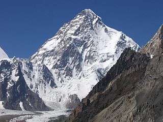
K2 in Gilgit–Baltistan is the second-highest mountain on Earth.
| Extremity | Name | Altitude | Location | Province/Territory | Coordinates |
|---|---|---|---|---|---|
| Highest | K2[1] | 8,611 m (28,251 ft) | Border between Gilgit–Baltistan and Xinjiang | Gilgit–Baltistan | 35°52′57″N 76°30′48″E / 35.88250°N 76.51333°E |
| Lowest | Near Sir Creek, Thatta | 0 m (0.0 ft) | Thatta District | Sindh | 23°41′42″N 68°08′56″E / 23.695°N 68.149°E |
Internal points
See also
Notes
- ↑ Coordinates obtained from Google Earth. Google Earth makes use of the WGS84 geodetic reference system.
References
| |||||||||||||||||||
| |||||||||||||||||||
| |||||||||||||||||||
| |||||||||||||||||||
| |||||||||||||||||||
| |||||||||||||||||||
| Sovereign states |
|
|---|---|
| States with limited recognition |
|
| Dependencies and other territories |
|
| |
This article is issued from
Wikipedia.
The text is licensed under Creative Commons - Attribution - Sharealike.
Additional terms may apply for the media files.