| Monogram | Town | County | Description | Location |
| A | Alton | Kane | | 37°26′21″N 112°28′58″W / 37.4393°N 112.4827°W / 37.4393; -112.4827 (Alton) (uncertain location) |
| BR | Tremonton | Box Elder | Bear River High School | 41°45′33″N 112°12′08″W / 41.7593°N 112.2021°W / 41.7593; -112.2021 (Bear River High School) |
| B | Beaver | Beaver | Beaver High School | 38°15′57″N 112°34′57″W / 38.2657°N 112.5825°W / 38.2657; -112.5825 (Beaver) |
| BL | Ogden | Weber | Ben Lomond High School | 41°15′02″N 111°55′51″W / 41.2506°N 111.9308°W / 41.2506; -111.9308 (Ben Lomond High School) |
| B | South Jordan | Salt Lake | Bingham High School | 40°34′07″N 112°06′59″W / 40.5686°N 112.1165°W / 40.5686; -112.1165 (Bingham High School) |
| B | Bountiful | Davis | Bountiful High School | 40°53′51″N 111°50′47″W / 40.8975°N 111.8463°W / 40.8975; -111.8463 (Bountiful) |
| B | Brigham City | Box Elder | Box Elder High School | 41°31′12″N 111°59′26″W / 41.52°N 111.9906°W / 41.52; -111.9906 (Brigham City) |
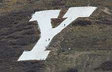
| Y | Provo | Utah | Brigham Young University | 40°14′54″N 111°37′14″W / 40.2483°N 111.6206°W / 40.2483; -111.6206 (Brigham Young University) |
| B | Cottonwood Heights | Salt Lake | Brighton High School | 40°36′35″N 111°47′09″W / 40.6096°N 111.7859°W / 40.6096; -111.7859 (Brighton High School) |
| BV | Tropic | Garfield | Bryce Valley High School | 37°37′28″N 112°03′46″W / 37.6245°N 112.0629°W / 37.6245; -112.0629 (Bryce Valley High School) |
| C | Price | Carbon | Carbon High School | 39°36′31″N 110°48′45″W / 39.6086°N 110.8125°W / 39.6086; -110.8125 (Carbon High School) |
| C | Cedar City | Iron | Cedar High School | 37°38′33″N 113°02′06″W / 37.6426°N 113.0351°W / 37.6426; -113.0351 (Cedar City) |
| C | East Carbon | Carbon | For the former town of Columbia | 39°30′51″N 110°23′07″W / 39.5142°N 110.3854°W / 39.5142; -110.3854 (Columbia) |
| C | Magna | Salt Lake | Cyprus High School | 40°42′29″N 112°07′56″W / 40.708°N 112.1322°W / 40.708; -112.1322 (Cyprus High School) |
| DIXIE | St. George | Washington | Dixie High School | 37°06′57″N 113°34′45″W / 37.1159°N 113.5792°W / 37.1159; -113.5792 (Dixie High School) |
| D | St. George | Washington | Dixie State University | 37°06′29″N 113°35′52″W / 37.1081°N 113.5977°W / 37.1081; -113.5977 (Dixie State University) |
| D | Duchesne | Duchesne | | 40°09′57″N 110°24′34″W / 40.1658°N 110.4094°W / 40.1658; -110.4094 (Duchesne) |
| EC | East Carbon | Carbon | East Carbon High School | 39°33′33″N 110°23′39″W / 39.559221°N 110.394149°W / 39.559221; -110.394149 (East Carbon High School) |
| E | Elsinore | Sevier | | 38°41′06″N 112°09′39″W / 38.6849°N 112.1607°W / 38.6849; -112.1607 (Elsinore) |
| E | Enterprise | Washington | | 37°33′09″N 113°44′54″W / 37.5525°N 113.7484°W / 37.5525; -113.7484 (Enterprise) |
| E | Escalante | Garfield | | 37°47′18″N 111°34′55″W / 37.7884°N 111.582°W / 37.7884; -111.582 (Escalante) |
| FREMONT COUNTRY | Beaver County | Beaver | Rough painted rocks mostly hidden among the sagebrush on a shallow south-facing hill adjacent to I-15 | 38°06′44″N 112°38′52″W / 38.1123°N 112.6479°W / 38.1123; -112.6479 (BEAVER COUNTY) |
| FG | Fountain Green | Sanpete | | 39°38′09″N 111°37′57″W / 39.6357°N 111.6326°W / 39.6357; -111.6326 (Fountain Green) |
| G | Glenwood | Sevier | | 38°46′26″N 111°58′57″W / 38.7738°N 111.9824°W / 38.7738; -111.9824 (Glenwood) |
| G | Moab | Grand | Grand County High School | 38°35′23″N 109°33′03″W / 38.5898°N 109.5509°W / 38.5898; -109.5509 (GCHS Block G) |
| G | Green River | Emery | | 38°59′07″N 110°10′06″W / 38.9853°N 110.1682°W / 38.9853; -110.1682 (Green River) |
| G | Gunnison | Sanpete | | 39°09′21″N 111°50′09″W / 39.1557°N 111.8357°W / 39.1557; -111.8357 (Gunnison) |
| G | Pleasant Grove | Utah | Short for "Grovarian", or "Grove" - the original mascot and old school nickname, respectively. [4] | 40°22′25″N 111°42′05″W / 40.3735°N 111.7013°W / 40.3735; -111.7013 (Pleasant Grove) |
| GREEN VALLEY | St. George | Washington | neighborhood | 37°05′46″N 113°37′22″W / 37.096°N 113.6228°W / 37.096; -113.6228 (neighborhood) |
| H | Henefer | Summit | | 41°00′34″N 111°30′10″W / 41.0094°N 111.5028°W / 41.0094; -111.5028 (Henefer) |
| H | Salt Lake City | Salt Lake | Highland High School | 40°43′50″N 111°48′41″W / 40.7306°N 111.8114°W / 40.7306; -111.8114 (Highland High School) |
| HOLE N' THE ROCK | | San Juan | Hole N' the Rock (Moab) | 38°23′28″N 109°27′16″W / 38.3911°N 109.4544°W / 38.3911; -109.4544 (Hole N' the Rock) |
| H | Hurricane | Washington | | 37°10′27″N 113°16′53″W / 37.1742°N 113.2815°W / 37.1742; -113.2815 (Hurricane) |
| I | Brigham City | Box Elder | Intermountain Indian School (closed) | 41°28′58″N 111°59′57″W / 41.4829°N 111.9993°W / 41.4829; -111.9993 (Intermountain Indian School (closed)) |
| J | Nephi | Juab | Juab High School | 39°44′29″N 111°49′06″W / 39.7415°N 111.8182°W / 39.7415; -111.8182 (Juab High School) |
| K | Kanab | Kane | | 37°02′54″N 112°31′03″W / 37.0482°N 112.5175°W / 37.0482; -112.5175 (Kanab) |
| K | Kingston | Piute | | 38°12′19″N 112°10′55″W / 38.2054°N 112.1819°W / 38.2054; -112.1819 (Kingston) |
| L | Lapoint | Uintah | | 40°24′37″N 109°47′18″W / 40.410375°N 109.788275°W / 40.410375; -109.788275 (Lapoint) |
| L | La Verkin | Washington | | 37°12′03″N 113°15′48″W / 37.2008°N 113.2632°W / 37.2008; -113.2632 (La Verkin) |
| L | Leeds | Washington | | 37°14′33″N 113°21′40″W / 37.2424°N 113.361°W / 37.2424; -113.361 (Leeds) |
| M | Mammoth | Juab | | 39°55′54″N 112°06′19″W / 39.9317°N 112.1052°W / 39.9317; -112.1052 (Mammoth) |
| M | Manila | Daggett | | 40°59′37″N 109°43′46″W / 40.9937°N 109.7294°W / 40.9937; -109.7294 (Manila) |
| M | Manti | Sanpete | | 39°15′45″N 111°36′36″W / 39.2624°N 111.6101°W / 39.2624; -111.6101 (Manti) |
| M | Marysvale | Piute | | 38°27′24″N 112°12′51″W / 38.4566°N 112.2143°W / 38.4566; -112.2143 (Marysvale) |
| M (no longer exists) | Milford | Beaver | | 38°23′55″N 113°00′35″W / 38.3986°N 113.0098°W / 38.3986; -113.0098 (Milford) (uncertain location) |
| M | Fillmore | Millard | Millard High School | 38°59′05″N 112°16′19″W / 38.9848°N 112.272°W / 38.9848; -112.272 (Millard High School) |
| M | Morgan | Morgan | | 41°01′42″N 111°39′32″W / 41.0283°N 111.659°W / 41.0283; -111.659 (Morgan) |
| M | Moroni | Sanpete | | 39°32′36″N 111°34′42″W / 39.5434°N 111.5782°W / 39.5434; -111.5782 (Moroni) |
| MC | Hyrum | Cache | Mountain Crest High School | 41°37′04″N 111°48′04″W / 41.6178°N 111.801°W / 41.6178; -111.801 (Mountain Crest High School) |
| NC | Richmond | Cache | North Cache Junior High School | 41°55′27″N 111°47′12″W / 41.9243°N 111.7867°W / 41.9243; -111.7867 (North Cache Junior High School) |
| NR | Laketown | Rich | North Rich Junior High School | 41°49′32″N 111°18′46″W / 41.8255°N 111.3127°W / 41.8255; -111.3127 (North Rich High School) |
| NS | Salina | Sevier | North Sevier High School | 38°57′21″N 111°49′19″W / 38.9557°N 111.8219°W / 38.9557; -111.8219 (North Sevier High School) |
| NS | Coalville | Summit | North Summit High School | 40°54′30″N 111°23′08″W / 40.9083°N 111.3855°W / 40.9083; -111.3855 (North Summit High School) |
| PC | Park City | Summit | Park City High School | 40°40′26″N 111°29′13″W / 40.6738°N 111.487°W / 40.6738; -111.487 (Park City) |
| P | Parowan | Iron | | 37°49′52″N 112°49′16″W / 37.8312°N 112.821°W / 37.8312; -112.821 (Parowan) |
| P | Payson | Utah | Payson High School | 40°01′30″N 111°42′59″W / 40.0249°N 111.7163°W / 40.0249; -111.7163 (Payson High School) |
| P | Peterson | Morgan | | 41°06′04″N 111°46′04″W / 41.1012°N 111.7678°W / 41.1012; -111.7678 (Peterson) |
| P | Junction | Piute | Piute High School | 38°14′34″N 112°14′42″W / 38.2427°N 112.245°W / 38.2427; -112.245 (Piute High School) |
| G | Pleasant Grove | Utah | | 40°22′24″N 111°42′04″W / 40.3734°N 111.7011°W / 40.3734; -111.7011 (Pleasant Grove) |
| R | Richfield | Sevier | | 38°45′41″N 112°06′43″W / 38.7614°N 112.1119°W / 38.7614; -112.1119 (Richfield) |
| R | Roosevelt | Duchesne | | 40°18′42″N 109°59′57″W / 40.311773°N 109.999249°W / 40.311773; -109.999249 (Roosevelt) |
| SJ | Blanding | San Juan | San Juan High School | 37°38′29″N 109°29′01″W / 37.6414°N 109.4835°W / 37.6414; -109.4835 (San Juan High School) |
| S | Shivwits | Washington | | 37°11′01″N 113°45′12″W / 37.1836°N 113.7534°W / 37.1836; -113.7534 (Shivwits) |
| S | Holladay | Salt Lake | Skyline High School (Utah) | 40°41′35″N 111°47′03″W / 40.693°N 111.7842°W / 40.693; -111.7842 (Skyline High School) |
| SV | Smithfield | Cache | Sky View High School | 41°49′16″N 111°47′57″W / 41.821°N 111.7992°W / 41.821; -111.7992 (Sky View High School) |
| S | Ephraim | Sanpete | Snow College | 39°20′39″N 111°32′21″W / 39.3441°N 111.5391°W / 39.3441; -111.5391 (Snow College) |
| SS | Monroe | Sevier | South Sevier High School | 38°37′54″N 112°06′03″W / 38.6316°N 112.1007°W / 38.6316; -112.1007 (South Sevier High School) |
| SS | Kamas | Summit | South Summit High School | 40°38′51″N 111°16′08″W / 40.6475°N 111.2689°W / 40.6475; -111.2689 (South Summit High School) |
| S | Sterling | Sanpete | | 39°11′40″N 111°41′57″W / 39.1945°N 111.6993°W / 39.1945; -111.6993 (Sterling) |
| T | Eureka | Juab | Tintic High School | 39°57′03″N 112°06′26″W / 39.9509°N 112.1071°W / 39.9509; -112.1071 (Tintic High School) |
| T | Tooele | Tooele | Tooele High School | 40°31′30″N 112°14′54″W / 40.5249°N 112.2482°W / 40.5249; -112.2482 (Tooele) |
| T | Tropic | Garfield | | 37°37′16″N 112°04′55″W / 37.621°N 112.0819°W / 37.621; -112.0819 (Tropic) |
| TRIDELL | Tridell | Uintah | | 40°27′15″N 109°50′43″W / 40.454203°N 109.845327°W / 40.454203; -109.845327 (Tridell) |
| U | Uintah | Weber | | 41°08′34″N 111°53′58″W / 41.1429°N 111.8995°W / 41.1429; -111.8995 (Uintah) |
| U | Vernal | Uintah | Uintah High School | 40°26′19″N 109°36′21″W / 40.4386°N 109.6057°W / 40.4386; -109.6057 (Uintah High School) |
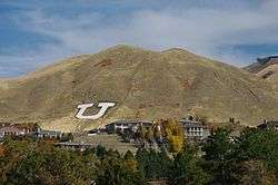
| U | Salt Lake City | Salt Lake | University of Utah | 40°46′46″N 111°50′24″W / 40.7794°N 111.8399°W / 40.7794; -111.8399 (University of Utah) |
| V | Orderville | Kane | Valley High School | 37°16′53″N 112°38′14″W / 37.2813°N 112.6371°W / 37.2813; -112.6371 (Valley High School) |
| V | Venice | Sevier | | 38°48′10″N 111°58′21″W / 38.8029°N 111.9724°W / 38.8029; -111.9724 (Venice) |
| V | Centerville | Davis | Viewmont High School | 40°54′34″N 111°51′21″W / 40.9094°N 111.8557°W / 40.9094; -111.8557 (Viewmont High School) |
| W | Wendover | Tooele | | 40°44′43″N 114°01′47″W / 40.7454°N 114.0297°W / 40.7454; -114.0297 (Wendover) |
| W | Montezuma Creek | San Juan | Whitehorse High School | 37°16′17″N 109°18′21″W / 37.2713°N 109.3059°W / 37.2713; -109.3059 (Whitehorse High School) |