Mammoth, Utah
| Mammoth | |
|---|---|
| Semi-ghost town | |
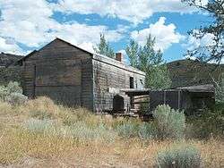 A home in Mammoth, October 2010 | |
 Mammoth Location of Mammoth within the State of Utah  Mammoth Mammoth (the US) | |
| Coordinates: 39°55′38″N 112°07′26″W / 39.92722°N 112.12389°WCoordinates: 39°55′38″N 112°07′26″W / 39.92722°N 112.12389°W | |
| Country | United States |
| State | Utah |
| County | Juab |
| Founded | 1870 |
| Named for | Mammoth Mine |
| Elevation[1] | 6,391 ft (1,948 m) |
| GNIS feature ID |
1451119[1] |
|
Mammoth Historic District | |
| Location |
Mammoth, Utah United States |
| Coordinates | 39°55′38″N 112°07′30″W / 39.92722°N 112.12500°W |
| Area | Approximately 170 acres (69 ha) |
| NRHP reference # | 79003468[2] |
| Added to NRHP | March 14, 1979 |
Mammoth is a semi-ghost town in northeastern Juab County, Utah, United States.[1]
Description
The townsite lies in Mammoth Canyon on the west flank of the East Tintic Mountains about 1.5 miles (2.4 km) west of Mammoth Peak at an elevation of 6,400 feet (2,000 m).[3] It is about 3 miles (4.8 km) south of Eureka and 2 miles (3.2 km) east of the Tintic Junction. Mammoth was founded around 1870 during the boom and bust mining cycle of the American West. The name for the town comes from the Mammoth Mine located near the area.
History
The Mammoth Mine was discovered around the same time as the settlement of Eureka in February 1870.[4] Miners rushed in and began a boomtown. The area was remote and the environment harsh; no water was to be found nearby. The mines piped in water for industrial use, but residents had to buy drinking water for ten cents a gallon.[5]
Mines in the area around Mammoth produced ore, silver, and gold. The Mammoth Mine was in production for around seventy-five years. Considered part of the Tintic Mining District, with other communities and mines in the area, the area around Mammoth played a vital role in the mining economy of the Utah Territory and later the State of Utah.
Activity in Mammoth peaked around 1900–1910, with a population of 2500–3000. The town had a school, four large hotels, and other businesses typical of a town its size. Mammoth was officially incorporated in 1910,[5] but began to decline soon after. By 1930 the population was down to 750,[4] the town having disincorporated on 29 November 1929.
Today, some residents still consider Mammoth home. There is some smaller scale mining that goes on in the area today for metals.
The area is also popular with ghost town enthusiasts, campers, off-road vehicle riders, and hikers.
Notable people
- Tristram Coffin (1909–1990), western actor and star of the syndicated 26 Men television series, was born in Mammoth.
- Marion Mack (8 April 1902 - 1 May 1989), silent era actress best-known for her work in the film classic The General, was born in Mammoth.
See also
References
- 1 2 3 "Mammoth". Geographic Names Information System. United States Geological Survey.
- ↑ National Park Service (2010-07-09). "National Register Information System". National Register of Historic Places. National Park Service.
- ↑ USGS 7.5 min. Quadrangle maps: Eureka and Tintic Junction
- 1 2 Thompson, George A. (Nov 1982). Some Dreams Die: Utah's Ghost Towns and Lost Treasures. Salt Lake City: Dream Garden Press. pp. 63–64. ISBN 0-942688-01-5.
- 1 2 Carr, Stephen L. (1986) [June 1972]. The Historical Guide to Utah Ghost Towns (3rd ed.). Salt Lake City: Western Epics. pp. 91–92. ISBN 0-914740-30-X.
External links
| Wikimedia Commons has media related to Mammoth, Utah. |
Municipalities and communities of Juab County, Utah, United States | ||
|---|---|---|
| Cities | 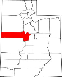 | |
| Towns | ||
| Unincorporated communities | ||
| Ghost towns | ||
| Indian reservation | ||
| Footnotes | ‡This populated place also has portions in an adjacent county or counties | |
| Topics | |
|---|---|
| Lists by states |
|
| Lists by insular areas | |
| Lists by associated states | |
| Other areas | |
| |