Shivwits, Utah
| Shivwits, Utah | |
|---|---|
| Unincorporated community | |
 Shivwits Location of Shivwits within the State of Utah  Shivwits Shivwits (the US) | |
| Coordinates: 37°10′52″N 113°45′27″W / 37.18111°N 113.75750°WCoordinates: 37°10′52″N 113°45′27″W / 37.18111°N 113.75750°W | |
| Country | United States |
| State | Utah |
| County | Washington |
| Elevation[1] | 3,202 ft (976 m) |
| Time zone | UTC-7 (Mountain (MST)) |
| • Summer (DST) | UTC-6 (MDT) |
| GNIS feature ID | 1437683[1] |
Shivwits is a small unincorporated community in west-central Washington County, Utah, United States.[1]
Description
The community is located along the Santa Clara River and the former routing of U.S. Route 91 within the Shivwits Reservation, northeast of the Beaver Dam Mountains and southwest of the Red Mountains.[2][3]
See also
![]()
References
- 1 2 3 "Shivwits". Geographic Names Information System. United States Geological Survey.
- ↑ "MyTopo Maps - Shivwits, UT, USA" (Map). mytopo.com. Trimble Navigation, Ltd. Retrieved 16 Mar 2018.
- ↑ Van Cott, John W. (1990). Utah Place Names: A Comprehensive Guide to the Origins of Geographic Names: A Compilation. Salt Lake City: University of Utah Press. p. 339. ISBN 978-0-87480-345-7. OCLC 797284427. Retrieved 16 Mar 2018.
External links
![]()
Municipalities and communities of Washington County, Utah, United States | ||
|---|---|---|
| Cities | 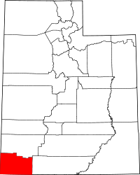 | |
| Towns | ||
| CDPs | ||
| Unincorporated communities | ||
| Ghost towns | ||
| Indian reservation | ||
| Footnotes | ‡This populated place also has portions in an adjacent county or counties | |
This article is issued from
Wikipedia.
The text is licensed under Creative Commons - Attribution - Sharealike.
Additional terms may apply for the media files.