List of World Heritage sites in Indonesia
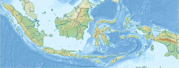
The UNESCO (United Nations Educational, Scientific and Cultural Organization) has designated 8 World Heritage sites in Indonesia.[1][2]
Selection is based on ten criteria: six for cultural heritage (i–vi) and four for natural heritage (vii–x).[3] Some sites, designated "mixed sites," represent both cultural and natural heritage. In Indonesia, there are 4 cultural, 4 natural, and no mixed sites.[1]
The World Heritage Committee may also specify that a site is endangered, citing "conditions which threaten the very characteristics for which a property was inscribed on the World Heritage List." Tropical Rainforest Heritage of Sumatra. A number of organizations have been pushing the Ministry of Culture to nominate more sites for UNESCO inclusion since 2015. Neighbors Philippines, Singapore, and India have been supportive of Indonesia's nominations in UNESCO, along with other ASEAN peers.
Legend
- Site; named after the World Heritage Committee's official designation[4]
- Location; at city, regional, or provincial level and geocoordinates
- Criteria; as defined by the World Heritage Committee[3]
- Area; in hectares and acres. If available, the size of the buffer zone has been noted as well. A value of zero implies that no data has been published by UNESCO
- Year; during which the site was inscribed to the World Heritage List
- Description; brief information about the site, including reasons for qualifying as an endangered site, if applicable
World Heritage sites
| Site | Image | Location | Criteria | Area ha (acre) |
Year | Description | Refs |
|---|---|---|---|---|---|---|---|
| Borobudur Temple Compounds | 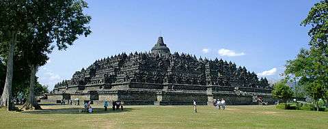 |
Magelang Regency, Central Java 7°36′28″S 110°12′13″E / 7.60778°S 110.20361°E |
Cultural: (i), (ii), (vi) |
— |
1991 | This famous Buddhist temple, dating from the 8th and 9th centuries, is located in central Java. It was built in three tiers: a pyramidal base with five concentric square terraces, the trunk of a cone with three circular platforms and, at the top, a monumental stupa. The walls and balustrades are decorated with fine low reliefs, covering a total surface area of 2,500 m2. Around the circular platforms are 72 openwork stupas, each containing a statue of the Buddha. The monument was restored with UNESCO's help in the 1970s. | 592[5] |
| Cultural Landscape of Bali Province: the Subak System as a Manifestation of the Tri Hita Karana Philosophy | 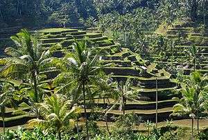 |
Bali 8°20′0″S 115°0′0″E / 8.33333°S 115.00000°E |
Cultural: (ii), (iii), (v), (vi) |
19,520 (48,200) | 2012 | The cultural landscape of Bali consists of five rice terraces and their water temples that cover 19,500 ha. The temples are the focus of a cooperative water management system of canals and weirs, known as subak, that dates back to the 9th century. Included in the landscape is the 18th-century Royal Water Temple of Pura Taman Ayun, the largest and most impressive architectural edifice of its type on the island. The subak reflects the philosophical concept of Tri Hita Karana, which brings together the realms of the spirit, the human world and nature. This philosophy was born of the cultural exchange between Bali and India over the past 2,000 years and has shaped the landscape of Bali. The subak system of democratic and egalitarian farming practices has enabled the Balinese to become the most prolific rice growers in the archipelago despite the challenge of supporting a dense population. | 1194rev[6] |
| Komodo National Park | 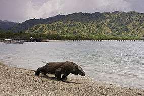 |
West Manggarai Regency, East Nusa Tenggara 8°33′S 119°29′E / 8.550°S 119.483°E |
Natural: (vii), (x) |
219,322 (541,960) | 1991 | These volcanic islands are inhabited by a population of around 5,700 giant lizards, whose appearance and aggressive behaviour have led to them being called 'Komodo dragons'. They exist nowhere else in the world and are of great interest to scientists studying the theory of evolution. The rugged hillsides of dry savannah and pockets of thorny green vegetation contrast starkly with the brilliant white sandy beaches and the blue waters surging over coral. | 609[7] |
| Lorentz National Park | 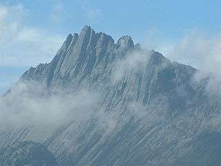 |
Papua 4°45′S 137°50′E / 4.750°S 137.833°E |
Natural: (vii), (ix), (x) |
2,350,000 (5,800,000) | 1999 | Lorentz National Park (2.35 million ha) is the largest protected area in South-East Asia. It is the only protected area in the world to incorporate a continuous, intact transect from snowcap to tropical marine environment, including extensive lowland wetlands. Located at the meeting-point of two colliding continental plates, the area has a complex geology with ongoing mountain formation as well as major sculpting by glaciation. The area also contains fossil sites which provide evidence of the evolution of life on New Guinea, a high level of endemism and the highest level of biodiversity in the region. | 955[8] |
| Prambanan Temple Compounds |  |
Central Java and Special Region of Yogyakarta 7°45′8″S 110°29′30″E / 7.75222°S 110.49167°E |
Cultural: (i), (iv) |
— |
1991 | Built in the 10th century, this is the largest temple compound dedicated to Shiva in Indonesia. Rising above the centre of the last of these concentric squares are three temples decorated with reliefs illustrating the epic of the Ramayana, dedicated to the three great Hindu divinities (Shiva, Vishnu and Brahma) and three temples dedicated to the animals who serve them. | 642[9] |
| Sangiran Early Man Site | 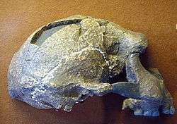 |
Sragen Regency, Central Java 7°24′0″S 110°49′0″E / 7.40000°S 110.81667°E |
Cultural: (iii), (vi) |
5,600 (14,000) | 1996 | Excavations here from 1936 to 1941 led to the discovery of the first hominid fossil at this site. Later, 50 fossils of Meganthropus palaeo and Pithecanthropus erectus/Homo erectus were found – half of all the world's known hominid fossils. Inhabited for the past one and a half million years, Sangiran is one of the key sites for the understanding of human evolution. | 593[10] |
| Tropical Rainforest Heritage of Sumatra† |  |
Aceh, Jambi, and Lampung 2°30′S 101°30′E / 2.500°S 101.500°E |
Natural: (vii), (ix), (x) |
2,595,124 (6,412,690) | 2004 | The 2.5 million hectare Tropical Rainforest Heritage of Sumatra site comprises three national parks: Gunung Leuser National Park, Kerinci Seblat National Park and Bukit Barisan Selatan National Park. The site holds the greatest potential for long-term conservation of the distinctive and diverse biota of Sumatra, including many endangered species. The protected area is home to an estimated 10,000 plant species, including 17 endemic genera; more than 200 mammal species; and some 580 bird species of which 465 are resident and 21 are endemic. Of the mammal species, 22 are Asian, not found elsewhere in the archipelago and 15 are confined to the Indonesian region, including the endemic Sumatran orang-utan. The site also provides biogeographic evidence of the evolution of the island. The site has been listed as endangered since 2011 due to poaching, illegal logging, agricultural encroachment, and plans to build roads. | 1167[11][12] |
| Ujung Kulon National Park | 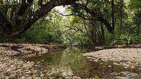 |
Banten and Lampung 6°45′S 105°20′E / 6.750°S 105.333°E |
Natural: (vii), (x) |
78,525 (194,040) | 1991 | This national park, located in the extreme south-western tip of Java on the Sunda shelf, includes the Ujung Kulon peninsula and several offshore islands and encompasses the natural reserve of Krakatoa. In addition to its natural beauty and geological interest – particularly for the study of inland volcanoes – it contains the largest remaining area of lowland rainforests in the Java plain. Several species of endangered plants and animals can be found there, the Javan rhinoceros being the most seriously under threat. | 608[13] |
Tentative list
The following 20 sites are on the Tentative List for Indonesia, meaning that the government intends to consider them for nomination in the future:[14]
| Site | Image | Location | Criteria | Area ha (acre) |
Year | Description | Refs |
|---|---|---|---|---|---|---|---|
| The Historic and Marine Landscape of the Banda Islands | 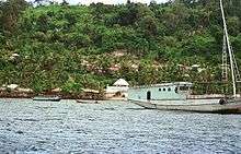 |
Central Maluku Regency, Maluku 40°28′0″S 129°39′0″E / 40.46667°S 129.65000°E |
Mixed: (iv), (vi), (x) |
— |
2015 | The Banda Islands are also known under the name 'Spice Islands’, as this island group was the original and sole location of the production of the spices nutmeg and mace during the most prosperous years of Dutch, English and Portuguese colonization. The Banda Islands are situated in the eastern part of the Indo-Malayan archipelago. It consists of eleven small volcanic islands, called Neira, Gunung Api, Banda Besar, Rhun, Ai, Hatta, Syahrir, Karaka, Manukan, Nailaka and Batu Kapal, with an approximate land area of 8,150 hectares in total. These islands were the scene of the earliest European ventures in Asia. In order to obtain a monopoly on the production and trade of nutmeg, the Dutch constructed a comprehensive nutmeg plantation system on the islands during the 17th century. It included the nutmeg plantations for spice production, several forts for the defense of the spices, and a colonial town for trading and governance. This system lasted until Indonesia’s independence in 1945, however these first commercial plantations remain the basis of today’s modern international trading system of nutmeg produce. The Dutch were not the only occupants of this region, however. The British skillfully negotiated with the village leaders on the island Rhun to protect them from the Dutch in exchange for a monopoly on their nutmeg. The village leader of Rhun accepted King James I of England as their sovereign, and it became the first overseas English colony. Control of the Banda Islands continued to be contested until 1667 when, in the treaty of Breda, the British ceded Rhun to the Dutch in exchange for the island of Manhattan (later New York City). | 6065[15] |
| Bawomataluo Site | 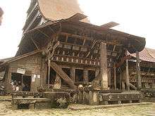 |
South Nias Regency, Nias, North Sumatra 00°36′59″N 97°46′17″E / 0.61639°N 97.77139°E |
Cultural: (i), (iv), (vi) |
5 ha | 2009 | The Bawomataluo settlement is located in the Bawomataluo Village, under the District of Teluk Dalam, in the South Nias Regency. The area covers ± 5 Hectares with an altitude of 270 meters above sea level. This kampong is situated on the heights of the hills and is relatively safe from any tsunami threats, despite having a distance of only 4 kilometers from the seashore. To enter this housing complex, one must go through a concrete stairway that resembles a terraced gravesite with 7 steps in the first section and 70 steps in the second part. The houses face each other with a distance of 4 meters apart and in the middle of the complex, there is a stone arrangement that is placed in an open space used for ceremonial customs and rituals. In between these traditional houses, newly built houses have been erected facing each other in a straight line from the northwest to the northeast. In the middle of the complex, there is a row of houses parallel towards the southeast. Inside the complex, there are 500 houses with a population of 7,000 that consists of 500 household heads. The Chief's or the King's house is located in the South West side and is the largest in the complex. Based on the genealogy/family tree of the community, it is stated that the designer of the houses was King Laowo as the founder of the Kingdom of this region and are descendants of the Gomo family. Later on, the construction of the house was finalized by Saonigeho (Siliwu Gere) who was also the first generation of the Laowo family. Currently, the house is occupied by the heirs from the fourth generation of the Laowo family. The house is estimated to have been built in 18th century. | 5463[16] |
| Betung Kerihun National Park (Transborder Rainforest Heritage of Borneo) |  |
West Kalimantan 0°40′0″N 112°15′0″E / 0.66667°N 112.25000°E |
Natural: (viii), (ix), (x) |
800,000 ha | 2004 | 1871[17] | |
| Bunaken National Park | 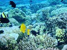 |
Manado, North Sulawesi 1°35′0″N 124°39′0″E / 1.58333°N 124.65000°E |
Natural: (vii), (viii), (ix), (x) |
280,000 ha | 2005 | This part of North Sulawesi was undergone multiple geologic stages. It is considered to be a ‘young’ continent of 5-24 million years of age which has undergone explosive volcanism more recently (1.5 to 5 million years ago) which resulted in the volcanic tuff that characterizes the existing topography. Manado Tua is an inactive volcano formed in a classical cone shape with a 27-45' slope. The island rises over 600 m above sea level, the highest elevation in the park. Bunaken Island has volcanic origins with a significant amount of uplifted fossil coral. At the west and central part of Bunaken Island (71m high) there is a flat plateau about 5Om above mean sea level (msl). Nain Island is also a dome-shaped island, 139m in height and with a slope of 20-40". Mantehage Island is relatively flat and seems to be sinking into the sea. The island has extensive mangrove forest flats, partially separated by saltwater channels. Siladen is a low-lying coral sand island with no significant topography. Arakan-Wawontulap and Molas-Wori on the mainland of North Sulawesi are relatively flat areas at the base of volcanic hills. The park has unique bathymetry which is an attraction for divers. The absence of a continental shelf in the northern part of North Sulawesi allows the coastal area of the park to drop directly down the continental slope. The sea depth between the islands of the park is 200-1,840m deep. In the coral ecosystem alone, Bunaken National Park covers an area of 89,095 hectares. The larger North Sulawesi area (also possessing potential for fbture inclusion in this WH site) contains approximately 280,000 ha. The marine national park area is home to thousands of different species of fish, coral, endangered marine mammals and reptiles, birds, molluscs and mangrove species. The Sanghie-Talaud island chain immediately to the north of the national park area is equally diverse (440 species from 52 sites in 2.3 million hectares). The uniqueness of Bunaken and the wider North Sulawesi area is its density of diversity in close proximity to a growing and populous part of Indonesia. | 2002[18] |
| Derawan Islands | 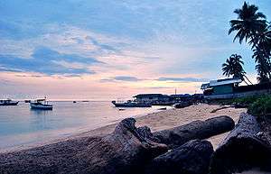 |
Berau Regency, East Kalimantan 2°15′0″N 118°25′0″E / 2.25000°N 118.41667°E |
Natural: (x) |
— |
2005 | Stretching over 100 miles along the coast of East Kalimantan, the Derawan island chain is one of the most biologically rich areas in all of Indonesia. Here, water from the Berau river mixing with the Sulawesi Sea created a unique seascape characterized by a broad river delta leading to a scattered groupings of patch reefs, fringing reefs, and atolls. | 2007[19] |
| Historical City Centre of Yogyakarta | 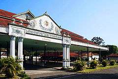 |
Special Region of Yogyakarta 7°48′03.8″S 110°21′53.3″E / 7.801056°S 110.364806°E}} |
Cultural: (i), (ii), (vi) |
1260 ha | 2017 | The historical city of Yogyakarta is a traditional Javanese city founded in 1756 by Pangeran Mangkubumi or the first Sultan Hamengkubuwana as the centre of the Sultanate of Ngayogyakarta Hadiningrat (henceforth: Kasultanan Yogyakarta). Distinct from other Javanese city, the city centre was designed based on specific Javanese cosmology and philosophy as manifested in its location and plan. The location of Yogyakarta city was deliberately chosen to precisely reflect microcosmos, whereas the plan of the city centre was drawn up based on the Javanese philosophy regarding the nature of human destiny. Accordingly, every component of the historical city centre of Yogyakarta has its own philosophical meaning. | 6206[20] |
| Kebun Raya Bogor | 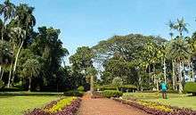 |
[[Indonesia Bogor, West Java 6°35′32.78″S 6°36′13.28″W / 6.5924389°S 6.6036889°W]] |
Cultural: (ii), (iv) |
75.4 ha | 2018 | Kebun Raya Bogor or Bogor Botanic Gardens (BBG) is an ex situ conservation area located in the administrative area of Bogor City, West Java Province, Indonesia. Area of BBG was 75.4 ha. Bogor Botanical Garden is at N 6º35‟32.78" S 6º36‟13.28" W 106º47‟36.72" E 106º48‟17.6". Bogor Botanic Gardens is one of the plant conservation areas that became important evidence in the historical development of science in Indonesia. There are more than 24 research institutions on natural sciences directly and directly established by Bogor Botanic Gardens located in Buitenzorg/Bogor. In the beginning the establishment of Bogor Botanic Gardens was intended as a place of acclimatization of plant species originating from foreign countries that have high economic value. Now, Bogor Botanic Gardens not only conserve the types of economic value, but also conserve the species of plants that are rare, endemic, scientific value and have the potential to be developed from the entire tropics. Collection of plants arranged in the form of blocks and grouped by taxonomic and thematic classification pattern. | 6353[21] |
| Muara Takus Compound Site | 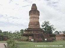 |
Kampar Regency, Riau 0°20′20″N 100°38′24.62″E / 0.33889°N 100.6401722°E |
Cultural: (i), (iv), (vi) |
— |
2009 | Muara Takus Site is administratively under the Muara Takus village, in the district of Koto Kampar XIII, which is situated in the Kampar regency of Riau province. The Kampar Kanan river divides Muara Takus into two regions. The river flowing northward forms a parabolic river bend. In the eastern side of the river, there is a small river which is known by the local people as the Umpamo or Limpamo river. The headwaters of this small river is located in the swamp areas in the southeast of Muara Takus and this small river ends in the Kampar Kanan river. The estuary of the Umpamo or Limpamo river is situated exactly at the northernmost curve of the Kampar Kanan River. In the past, a human settlement was situated at the inner side and northern side of the river bend, but more specifically in the eastern side of the river. However, due to the hydro-power electricity plant development project, both sub-village regions were relocated to a new location approximately 1.5 kilometres southwards of the former settlement. | 5464[22] |
| Muarajambi Temple Compound | 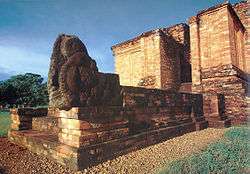 |
Muaro Jambi Regency, Jambi 1°24′0″S 103°2′0″E / 1.40000°S 103.03333°E |
Cultural: (ii), (iii), (iv) |
2062 ha | 2009 | The Muarajambi Temple Compound Site is located in the Muarajambi Village, in the District of Maro Sebo, Muaro Jambi Regency, Jambi Province. From Jambi city, the site is less than 40 kilo-meters and can be reached by land transportation or through the river in one hour. The site is spread along 7.5 kilo-meters of the riverbanks of Batanghari River in which old canals or man-made rivers are positioned to connect the Batanghari River with the site. Through these ancient canals that circulate the site, people could reach the temple compounds. In the Muarajambi Temple Compound Site that covers an area of 2062 hectares, there were at least 82 ruins of ancient buildings made of brick construction. Seven of these ancient temples have been given intensive conservation treatment; meanwhile the remaining structures are covered with primary and secondary vegetation, and surrounded by the local community plantation of Sumatran endemic plants (planted by the local people known as Menapo). The seven temple compounds are the Gumpung, Tinggi I, Tinggi II, Kembar Batu, Astano, Gedong I and Gedong II, and the Kedaton Temple. In addition to that conservation treatment, several of the ancient canals and the old ponds that were previously covered with water vegetation have been cleared and are now restored to normal, such as the ancient canals in Jambi River and the Telago Rajo Pond. Based on archaeology research and historical sources, the Muarajambi Temple Compound Site was once the centre for worship and education of the Buddhist religion in the period of the Ancient Malay Kingdom in the 7th - 14th century AD. | 5464[23] |
| Prehistoric Cave Sites in Maros-Pangkep |  |
Maros Regency, South Sulawesi 4°42′49″S 119°34′17″E / 4.71361°S 119.57139°E |
Natural: (ix) |
21,631 ha forest area, 43,750 ha the Karst Maros-Pangkep area | 2009 | In general, the karst landscape is hilly and has mountainous terrains. The mountainous area is situated in the north east or located in the Bulusaraung Mountains. The highest peak of the mountain is 1,565 m above sea level in the northern side of Bulusaraung Mountain. This side of the mountain has a steep slope with rough texture. The climate in the Maros Pangkep area is tropical with the dry season between the months of November to April meanwhile the rainy season runs from May to October. The temperature ranges from 210 C - 310 C or on average 26.40 C, with fluctuating humidity. The area of the Pangkep conservation forest covers around ± 21.631 hectares from the total forest area of 32.503 hectares. Most of the conservation forest is within the karst area that is part of the National Park of Bantimurung and Bulusaraung (Babul). | 5467[24] |
| Raja Ampat Islands | 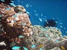 |
West Papua province 0°30′0″N 124°30′0″E / 0.50000°N 124.50000°E |
Natural: (vii), (x) |
4.6 million ha | 2005 | The Raja Ampat Islands, situated near the Northwest coast of Papua, consists of about 1,500 islands, including several large, mountainous islands, the largest being Waigeo, Batanta, Salawati and Misool. The land and surrounding sea occupy approximately 46,000 km2 or about 4.6 million ha. The islands are located in a region on the western boarder of the equatorial Pacific Ocean and at the Northeastern ‘entrance’ of the Indonesian Throughflow from the Pacific to the Indian Ocean. The vast majority of the archipelago rests on the Sahul shelf. The wide distribution of small islands across the shelf edge creates a strong gradient from clear water, open oceanic conditions to sheltered and turbid bays, surrounded by karst limestone formations. | 2003[25] |
| Taka Bonerate National Park | Selayar Regency, South Sulawesi 6°16′0″S 120°54′0″E / 6.26667°S 120.90000°E |
Natural: (vii), (viii), (ix), (x) |
530,765 ha | 2005 | The Bonerate National Park is home to the third biggest atoll in the world after Kwajifein in the Marshall Isles and Suvadiva in the Moldiva Isles. The total area of the atoll is about 220,000 hectares with coral reefs spreading over 500km2. The national park includes an area of 530,765 ha. Taka Bonerate is a Bugis’s name that somewhat has a meaning ‘Coral Piled Up On Sand’. There are 15 islands in taka Bonerate National Park where visitors can enjoy diving, snorkelling and marine tours. | 2005[26] | |
| Tana Toraja Traditional Settlement | 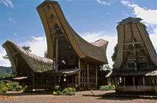 |
Tana Toraja Regency, South Sulawesi 2°36′0″S 119°22′0″E / 2.60000°S 119.36667°E |
Cultural: (iv), (v), (vi) |
3,205 km2 | 2009 | Tana Toraja Traditional Settlement is a series of 10 traditional settlements or constituents of them, such as burial or ceremonial grounds. The properties are scattered within Tana Toraja Regency in the Province of South Sulawesi, Indonesia. Tana-Toraja occupies about 3.205 km2 of a relatively hilly terrain with plateaus rising from 300 to 2,800 meters above sea level. The nominated Tana Toraja Traditional Settlement consists of 10 sites which are dispersed in the Tana Toraja Regency (see part I). Traditionally, a Toraja settlement consists of a compound of houses (tongkonan) and granaries (alangs), burials (liang), ceremonial grounds with menhirs (rante), rice-fields, bamboo forests, and grazing ground or pasture for buffalo and pigs. However, not all the nominated sites possess all the settlement components, on account of developmental changes in each site. A brief description of the nominated sites is provided in part I Identification of the Property. The following descriptions present some complementary information about each site. | 5462[27] |
| Trowulan - Former Capital City of Majapahit Kingdom | 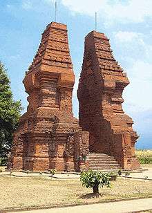 |
Mojokerto Regency, East Java 7°30′0″S 112°18′0″E / 7.50000°S 112.30000°E |
Cultural: (i), (v) |
99 km2 | 2009 | The Trowulan site is the only city site of the Hindu-Budha classical age in Indonesia that can still be found. The site covers an area of 11 km x 9 km, which includes the Districts of Trowulan and Sooko within the Regency of Mojokerto and the Districts of Mojoagung and Mojowarno under the Jombang Regency. The site of the former capital city of the Majapahit Kingdom was built on flat terrains at the foot of three mountains, namely the Penanggungan, Welirang, and Anjasmara Mountain. Geographically, the Trowulan area was suitable for human settlement since it was supported by plane topography with relatively shallow ground water. Hundreds of thousands of archaeological remnants of the old city in the Trowulan Site were found buried underground as well as on the surface in the form of: artifacts, eco-facts, and features. | 5466[28] |
| Wakatobi National Park | 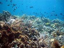 |
Buton Regency, Southeast Sulawesi 5°12′0″S 123°20′0″E / 5.20000°S 123.33333°E |
Natural: (vii), (viii), (ix), (x) |
1,390,000 ha | 2005 | Wakatobi National Park has very high marine resource potential, in terms of both species and uniqueness, with enchanting submarine landscapes. In terms of configuration, the marine waters of the park generally start flat and then slope seawards, with sheer precipices in some parts. The water depth varies, the deepest parts reaching 1,044 metres with sand and coral at the bottom. This Park has 25 chains of coral reefs, and the total circumference of the coral islands is 600 km. The National Park includes an area of 1,390,000 hectares. | 2006[29] |
| Sangkulirang - Mangkahilat Karts: Prehistoric rock art area | East Kalimantan | Cultural: (iii) |
- | 2015 | The property is situated in the midle-eastren part of East Kalimantan Province, at Sangkulirang-Mangkalihat Peninsula. It contains thousands of red rock-art paintings, and some sites with engraving located at 35 sites in seven different karst mountain areas at the head of the Sangkulirang-Mangkalihat Peninsula (Merabu, Batu Raya, Batu Gergaji, Batu Nyere, Batu Tutunambo, Batu Pengadan and Batu Tabalar). | 6009[30] | |
| The Old Town of Jakarta (Formerly old Batavia) and 4 Outlying Islands (Onrust, Kelor, Cipir dan Bidadari) | 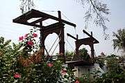 |
Jakarta | Cultural: (ii),(iii),(iv),(v) |
- | 2015 | Located at the mouth of the Ciliwung River in Java , the Old Town of Jakarta was established by the VOC in 1619. Its 17th century town plan was completed in 1650. In 17th and 18th century VOC had largest volume of trade in the world, governed from Batavia. No colonial town built by VOC matched the grandeur and completeness (military, civil engineering, and urban elements) of Dutch town planning & architecture of Batavia. The nominated property: the 1650 town (1.5 km x 1 km) with 4 major areas on the Ciliwung River sides. West side: former Jayakarta and two 18th century houses. North west side: West Warehouse, old town wall remains, Floating Warehouse, VOC shipyard, Luar Batang Mosque. East side: East Warehouse, Town Square, Town Hall. South east side: China Town. Kalibesar Canal with traditional boats wharf. Islands: Onrust, Kelor, Cipir & Bidadari with shipyard and forts. | 6010[31] |
| Semarang Old Town | 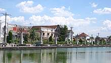 |
Central Java | Cultural: (ii),(iv) |
- | 2015 | Semarang is a colonial city par exellence. Established in 17th century, Kota Lama Semarang is a best preserved colonial city with remarkable testimony of important historical phases of human civilization - in economic, political and social - in the South East Asia and the World. Although it is today a sprawling metropolis of 1.2 million inhabitants, it’s old centre retains a group of buildings with various architectural styles coming from medieval, baroque and modern style. It’s unique urban landscape shows a development of a fortified city which is growing in to an international and cosmopolitan port city in it’s age. There fore it is worth to preserve Kota Lama Semarang, especilly from today’s thread: extensive flooding and land subsidence. | 6011[32] |
| Sawahlunto Old Coal Mining Town | 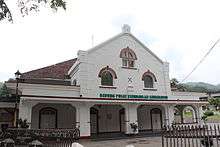 |
West Sumatra | Cultural: (ii),(iv) |
- | 2015 | Sawahlunto is the oldest coal mining town in South East Asia. The municipality of Sawahlunto of West Sumatera is geographically located in a narrow-isolated valley along the Bukit Barisan mountain range. The Town itself is surrounded by several hills, namely Bukit Polan, Bukit Pari, and Bukit Mato. At the end of the 19th century, Dutch Indies had discovered and further exploited coal in Sawahlunto. Since then, this rural area developed and become a mining site. | 6057[33] |
| Traditional Settlement at Nagari Sijunjung | 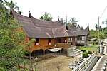 |
Sijunjung Regency, West Sumatra | Cultural: (iii),(v) |
- | 2015 | Traditional Settlement at Nagari Sijunjung (Perkampungan Adat Nagari Sijunjung) located at two villages, Jorong Koto Padang and Tanah Bato, of Sijunjung regency of West Sumatra. The main setting of settlement is in a linier position lies between two large rivers, namely Batang Sukam and Batang Kulampi. The compound of traditional houses is surrounded by hills, forest, paddy fields, and plantation. There are 76 houses in this area inhabited by nine clans and their subordinate clans. The traditional houses symbolize matrilineal-based clans in nagari, customary village of Minangkabau. It consists of paddy fields and plantation, graveyards, mosques and madrasah-Islamic school, market, and balai adat (customs hall). | 6059[34] |
Performance of Indonesia in UNESCO
| UNESCO List | Exclusive Entries of Indonesia | Shared/Multinational Entries Involving Indonesia |
|---|---|---|
| UNESCO World Network of Biosphere Reserves | 11 | — |
| UNESCO World Heritage List | 8 | — |
| UNESCO Memory of the World Register | 3 | 5 |
| UNESCO Global Geoparks Network | 6 | — |
| UNESCO Creative Cities Network | 2 | — |
| UNESCO Intangible Cultural Heritage Lists | 9 | — |
See also
Notes
- 1 2 "World Heritage Properties in Indonesia". UNESCO. Retrieved 1 July 2012.
- ↑ "Composition of macro geographical (continental) regions, geographical sub-regions, and selected economic and other groupings". Geographical region and composition of each region. United Nations Statistics Division. 2010. Retrieved 20 October 2011.
- 1 2 "The Criteria for Selection". UNESCO. Retrieved 10 September 2011.
- ↑ "World Heritage List Nominations". UNESCO. Retrieved 28 May 2010.
- ↑ "Borobudur Temple Compounds". UNESCO. Retrieved 28 May 2010.
- ↑ "Cultural Landscape of Bali Province". UNESCO. Retrieved 1 July 2012.
- ↑ "Komodo National Park". UNESCO. Retrieved 28 May 2010.
- ↑ "Lorentz National Park". UNESCO. Retrieved 28 May 2010.
- ↑ "Prambanan Temple Compounds". UNESCO. Retrieved 28 May 2010.
- ↑ "Sangiran Early Man Site". UNESCO. Retrieved 28 May 2010.
- ↑ "Tropical Rainforest Heritage of Sumatra". UNESCO. Retrieved 25 June 2011.
- ↑ "Danger listing for Indonesia's Tropical Rainforest Heritage of Sumatra". UNESCO. Retrieved 26 July 2011.
- ↑ "Ujung Kulon National Park". UNESCO. Retrieved 28 May 2010.
- ↑ "Tentative Lists: Indonesia". UNESCO. Retrieved 8 April 2012.
- ↑ "Banda Islands". UNESCO. Retrieved 12 August 2015.
- ↑ "Bawomataluo Site". UNESCO. Retrieved 8 April 2012.
- ↑ "Betung Kerihun National Park". UNESCO. Retrieved 8 April 2012.
- ↑ "Bunaken National Park". UNESCO. Retrieved 8 April 2012.
- ↑ "Derawan Islands". UNESCO. Retrieved 8 April 2012.
- ↑ "Historical City Centre of Yogyakarta". UNESCO. Retrieved 18 April 2018.
- ↑ "Kebun Raya Bogor". UNESCO. Retrieved 22 July 2018.
- ↑ "Muara Takus Compound Site". UNESCO. Retrieved 8 April 2012.
- ↑ "Muarajambi Temple Compound". UNESCO. Retrieved 8 April 2012.
- ↑ "Prehistoric Cave Sites in Maros-Pangkep". UNESCO. Retrieved 8 April 2012.
- ↑ "Raja Ampat Islands". UNESCO. Retrieved 8 April 2012.
- ↑ "Taka Bonerate National Park". UNESCO. Retrieved 8 April 2012.
- ↑ "Tana Toraja Traditional Settlement". UNESCO. Retrieved 8 April 2012.
- ↑ "Trowulan - Former Capital City of Majapahit Kingdom". UNESCO. Retrieved 8 April 2012.
- ↑ "Wakatobi National Park". UNESCO. Retrieved 8 April 2012.
- ↑ "Sangkulirang - Mangkahilat Karts: Prehistoric rock art area". UNESCO. Retrieved 12 August 2015.
- ↑ "The Old Town of Jakarta (Formerly old Batavia) and 4 Outlying Islands (Onrust, Kelor, Cipir dan Bidadari)". UNESCO. Retrieved 12 August 2015.
- ↑ "Semarang Old Town". UNESCO. Retrieved 12 August 2015.
- ↑ "Sawahlunto Old Coal Mining Town". UNESCO. Retrieved 12 August 2015.
- ↑ "Traditional Settlement at Nagari Sijunjung". UNESCO. Retrieved 12 August 2015.
| Wikimedia Commons has media related to World Heritage Sites in Indonesia. |
References
- General
- "World Heritage Committee: Sixteenth session" (PDF). UNESCO. Retrieved 28 May 2010.
- "World Heritage Committee: Twenty-eighth session" (PDF). UNESCO. Retrieved 26 June 2011.
- "Detailed list of UNESCO World Heritage Sites in Indonesia with large pictures".
| Northern and Central Asia | ||
|---|---|---|
| Western Asia (including Arab States) | ||
| Eastern Asia |
| |
| Southern Asia |
| |
| Southeast Asia | ||
| History |  | ||||||
|---|---|---|---|---|---|---|---|
| Geography |
| ||||||
| Politics | |||||||
| Economy | |||||||
| Culture |
| ||||||