Kampar Regency
| Kampar Regency (Kabupaten Kampar) | |||
|---|---|---|---|
| Regency | |||
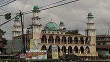
.JPG) Islamic Centre of Kampar in Bangkinang city | |||
| |||
 | |||
| Coordinates: 1°00′40″N 101°14′30″E / 1.01111°N 101.24167°ECoordinates: 1°00′40″N 101°14′30″E / 1.01111°N 101.24167°E | |||
| Country | Indonesia | ||
| Province | Riau | ||
| Capital | Bangkinang | ||
| Government | |||
| • Regent | Jefri Noer | ||
| Area | |||
| • Total | 10,983.47 km2 (4,240.74 sq mi) | ||
| Population (2014) | |||
| • Total | 790,132 | ||
| • Density | 72/km2 (190/sq mi) | ||
| Time zone | UTC+7 (WIB) | ||
| Website | www.kamparkab.go.id | ||


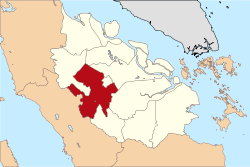
Kampar is a regency (kabupaten) of Riau Province on the island of Sumatra, Indonesia. It has an area of 10,983.47 km² and had a population of 686,204 at the 2010 Census; the latest official estimate (as at January 2014) was 790,132.
The regency is divided into 20 districts (kecamatan). The administrative centre of the regency is located at Bangkinang.
Bordered by:
| Heading | Border |
|---|---|
| North | Bengkalis, Siak and Rokan Hulu Regency |
| South | Kuantan Singingi Regency |
| West | LIma Puluh Kota Regency, West Sumatera |
| East | Pelalawan and Pekanbaru city |
Geography
Kampar Regency covers an area of approximately 10,983.47 km2, and is an area that lies between 1 ° 00'40 "north latitude to 0 ° 27'00" south latitude and 100 ° 28'30 "- 101 ° 14'30" east longitude. [ 6] The boundaries of Kampar Regency are as follows: North Rokan Hulu and Bengkalis Southern Regency Kuantan Singingi Fifty-City West District (West Sumatra Province) East Pekanbaru, Siak and Pelalawan Kampar district is traversed by two major rivers and several small rivers, including Sungai Kampar ± 413.5 km long with an average depth of 7.7 m and an average width of 143 meters. All parts of the river is included in Kampar District, which includes District XIII Koto Kampar, Bangkinang, Bangkinang West, Kampar, Siak Hulu, and Kampar Kiri. Then the Siak River upstream part of the length of ± 90 km with an average depth of 8–12 m across districts Tapung. Major rivers located in Kampar Regency are partly still functioning well as a means of transportation, clean water sources, fish farms, as well as a source of electrical energy (hydropower Koto Panjang). Kampar district generally tropical climate, the minimum temperature occurred in November and December in the amount of 21 °C. The maximum temperature occurs in July with a temperature of 35 °C. Number of rainy days in 2009, the vast majority were around Bangkinang Seberang and Kampar Kiri.
Government
Kampar was originally located in the province of Central Sumatra, established pursuant to Law No. 12 of 1956 with the capital Bangkinang. Then it was moved into Riau province, based on the Law on Emergency Number 19 Year 1957 and confirmed by Law No. 61 1958. Subsequently, for the development of the city of Pekanbaru, Kampar local government agreed to give up some of its territory for the purposes of expansion of the city of Pekanbaru, which was then confirmed by the Indonesian Government Regulation Number 19 of 1987.
In accordance with the Decree of the Governor of the Province of Riau Number: KPTS. 318VII1987 dated July 17, 1987, Kampar District consists of 19 districts with two Vice Regent. Vice Regent of Region I is based in Pasir Pangarayan and Vice Regent of Region II in Pangkalan Kerinci. Regent Assistant Region I coordinate the District of Rambah, Tandun, Rokan IV Koto, Kunto Darussalam, Fullness, and Tambusai. Regent Assistant coordinate the District of Region II Langgam, Pangkalan Kuras, Bunut and Kuala Kampar. While other districts are not included maid region regent I & II region directly under the district coordinator. Kampar Regency is currently led by partner Jeffery H. Noer Governor and Deputy Governor H. Ibrahim Ali SH, which is set by the plenary session the General Election Commission (KPU) Kampar for a term of 2011-2016.
Districts
Kampar Regency is divided into 20 districts (kecamatan), as a result of the reorganisation of the previous 12 districts. The twenty districts (with their administrative centres) are tabulated below with their 2010 Census populations: [1]
| Name District | Capital of District | Population |
|---|---|---|
| Bangkinang | Bangkinang (town) | 34.899 |
| Bangkinang Barat | Kuok | 22.128 |
| Bangkinang Seberang | Muara Uwai | 29.087 |
| Gunung Sahilan | Kebun Durian | 17.145 |
| Kampar | Air Tiris | 44.546 |
| Kampar Kiri | Lipat Kain | 26.193 |
| Kampar Kiri Hulu | Gema | 10.542 |
| Kampar Kiri Hilir | Sungai Pagar | 10.089 |
| Kampar Kiri Tengah | Simalinyang | 23.590 |
| Kampar Timur | Kampar (town) | 21.303 |
| Kampar Utara | Sawah | 15.157 |
| Perhentian Raja | Hang Tuah | 15.404 |
| Rumbio Jaya | Teratak | 15.165 |
| Salo | Salo | 22.775 |
| Siak Hulu | Pangkalan Baru | 85.881 |
| Tambang | Tarai Bangun | 52.634 |
| Tapung | Petapahan | 82.249 |
| Tapung Hulu | Senama Nenek | 55.663 |
| Tapung Hilir | Sekijang | 52.123 |
| XIII Koto Kampar | Batu Bersurat | 37.811 |
Demography
The total population of Kampar Regency in 2010 recorded 688.204 persons, which consists of the male population and female souls 354.836 and 333.368 inhabitants. Sex ratio (the ratio of the male population to the female population) is 109. The Kampar population is Minangkabau who often refer to themselves as Ughang Ocu, spread over most of Kampar region with Tribal Domo, Malay, Piliong / Piliang, Mandailiong, Putopang, Caniago, Kampai, Bendang, etc. In history, ethnicity, customs, and their culture is very close to the Minangkabau society. Particularly with Limopuluah Luhak region. This happens because the new Kampar region apart from Minang since the Japanese colonial period in 1942. According to his H.Takahashi in Japan and Eastern Asia, 1953, the Military Government Kaigun Kampar in Sumatra enter into Shio Riau region as part of a strategy of territorial defense military on the East coast of Sumatra. Furthermore, there is also little ethnic Malays who generally live in the border areas bordering East with Siak and Pelalawan. Followed by ethnic Javanese majority have settled in Kampar since the colonial period and independence through transmigration programs scattered centers of transmigration settlements. Similarly Batak ethnic population found in large enough quantities to work as laborers in the plantation sector and other services. Besides the significant number of migrants of other tribes from West Sumatra Minangkabau who made their living as traders and businessmen. The most densely populated district that is Kampar district is 333 inhabitants / km², followed by North Kampar District 226 inhabitants / km². In addition five rather densely populated districts located in the District Rumbio Jaya, Bangkinang, Bangkinang West, stop King and East Kampar, each -masing 216 inhabitants / km², 191 inhabitants / km², 158 inhabitants / km², 154 and 131 inhabitants / km² , While two relatively sparsely populated districts namely Kampar Kiri Hulu with a density of 9 inhabitants / km² and Kampar Kiri Hilir with 13 inhabitants / km².
Religion
Kampar Regency has a resident Muslim majority, with minorities of Protestants, Catholics, Buddhists, and Hindus. Islam accounts for nearly 90% of total religious adherents throughout the regency. Subsequent Christian religions are the second larges, accounting for 8.6% . Moslems were the highest in Sub Siak Hulu as many as 63 511 people . Although in general all District in Kampar is a Muslim majority . Jami Air Tiris, including one of the oldest mosques in Kampar regency
Economy
Kampar Regency still has a lot of potential that can be exploited, especially in agriculture and aquaculture. Most of the population (67.22%) work in agriculture, plantation and forestry. Only a small fraction (12:22%) were working in the sector of Electricity, Gas and Water, as well as government. As one of the largest area in the province of Riau, Kampar ongoing basis to improve the facilities and infrastructure such as road network (1856.56 km), electricity (72.082 KWH) with 5 units of diesel power plant Hydroelectric Power Plant (HEPP) in Koto length that produces energy with a capacity of 114.240 KWH connected. Other facilities also include telecommunications services (fixed line, mobile phone and internet networks) and water network with a production capacity of 1,532,284 m³. Agriculture Agriculture such as palm oil and rubber, which is one plant that is suitable for land in Kampar regency. Plantation Special plantations for palm oil plantations currently Kampar district has a land area of 241.5 thousand hectares with potential for crude palm oil (CPO) as much as 966 thousand tons. Fishery In the field of aquaculture catfish developed through cages (fish pond in the form of rafts) along the Kampar river, seen the number of cages were lined up neatly along the river kampardan the cooperation between the Government of Kampar PT. Benecom with a total investment of Rp. 30 billion of which in the future will become a center Kampar catfish with a production of 220 tonnes per day.
Tourism and culture
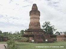
Kampar Regency has an estimated area of archaeological sites have been there during the Srivijaya namely Muara Takus, this region besides being a cultural heritage area is also a religious tourist destination for Buddhists. In addition Kampar Muslim community, still preserve the tradition Balimau Bakasai i.e. shower bath wash in Kampar River particularly welcome the month of Ramadan.
Then there is also the tradition that is the tradition Ma'awuo fish catch fish together (fishing ban) once a year, especially in the area of Lake Bokuok (District of Mine) and Subayang River in the village of Domo (Kampar Kiri Hulu). Kampar culture can not be separated from the influence of Minangkabau, which is identical with the title Limo Koto Kampar and formerly part of Pagaruyung. Limo Koto consists of Kuok, Salo, Bangkinang, Air Tiris and Rumbio. There are many tribal are still preserved to this day, including kinship models of maternal lines (matrilineal). The concept of custom and tradition together with the concept Minang tribe especially in Luhak Limopuluah.
Language and Music
Colloquially Kampar society similar to the Minangkabau language, or the so-called language Ocu one variant which is similar to the language used in Luhak Limopuluah. The language is different accent variants Minangkabau language spoken by the people of Luhak Agam, Tanah Datar Luhak Minangkabau and other coastal areas. In addition, Limo Koto Kampar also have some sort of a traditional musical instrument called Calempong and Oguong.
Capital: Pekanbaru | ||
| Regencies | ||
| City | ||
| Capital of Regency |
| |
| Islands | ||
References
- ↑ Central Bureau of Statistics: Census 2010 Archived 2010-11-13 at the Wayback Machine., retrieved 17 January 2011 (in Indonesian)