Central Maluku Regency
| Central Maluku Regency Kabupaten Maluku Tengah | ||
|---|---|---|
| Regency | ||
| ||
| Motto(s): Pamahanunusa | ||
 Location within Maluku | ||
| Coordinates: 3°17′30″S 128°58′03″E / 3.29167°S 128.96750°ECoordinates: 3°17′30″S 128°58′03″E / 3.29167°S 128.96750°E | ||
| Country | Indonesia | |
| Province | Maluku | |
| Capital | Masohi | |
| Government | ||
| • Regent | Tuasikal Abua | |
| • Vice Regent | Marlatu L. Leleury | |
| Area | ||
| • Total | 7,953.61 km2 (3,070.91 sq mi) | |
| Population (2014) | ||
| • Total | 402,900 | |
| • Density | 51/km2 (130/sq mi) | |
| Time zone | UTC+9 (IEST) | |
| Area code | (+62) 914 | |
| Website |
maltengkab | |

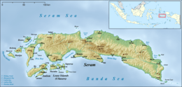

Central Maluku Regency (Indonesian: Kabupaten Maluku Tengah) is a regency of Maluku, Indonesia. The Regency covers an area of 7,953.61 km2, and had a population of 361,698 at the 2010 Census;[1]. there was an estimate of 434,490 quoted as at 6 December 2012[2], but the most recent official estimate (as at January 2014) was 402,900. The principal town lies at Masohi, on Seram Island. The regency (kebupaten) is composed of the central part of the island of Seram, the Banda Islands, and the Lease Islands (Saparua, Haruku, and Nusa Laut), together with those parts of Ambon Island which are outside the City of Ambon.
This regency is the second largest in area among Malukan regencies after Aru Islands Regency.[2]
Administration
The regency is divided into eighteen districts (kecamatan),[3] tabulated below with their areas (in km2) and their populations at the 2010 Census.[4] The final column gives the Indonesian Population Aggregate Data by District (DAK2) as at 6 December 2012.[2]
| Name | English name | Administrative Centre | Area in km2 | Population Census 2010 | Population DAK2 December 2012 |
|---|---|---|---|---|---|
| Leihitu | Hila | 216.5 | 46,978 | 58,340 | |
| Leihitu Barat | West Leihitu | Larike | 145.5 | 16,678 | 20,715 |
| Sala Hutu | Tulehu | 143.3 | 46,703 | 53,322 | |
| (totals on Ambon Island) | 505.3 | 110,359 | 132,377 | ||
| Pulau Haruku | Haruku Island | Pelauw | 174.8 | 24,207 | 29,715 |
| Saparua | Kota Saparua | 168.1 | 32,475 | 20,202 | |
| Saparua Timur | East Saparua | Tuhaha | (Note 1) | (Note 1) | 18,481 |
| Nusa Laut | North Nusa | Ameth | 26.8 | 5,322 | 6,610 |
| (totals on Lease Islands) | 369.7 | 62,004 | 75,008 | ||
| Amahai | Amahai | 1,243.8 | 38,932 | 48,630 | |
| Kota Masohi | Masohi Town | Masohi | 5.5 | 31,480 | 38,735 |
| Seram Utara | North Seram | Wahai | 3,401.1 | 39,249 | 20,302 |
| Seram Utara Barat | Northwest Seram | Pasanea | 822.4 | 9,260 | 11,520 |
| Seram Utara Timur Kobi | North East Seram of Kobi | Kobi | (Note 2) | (Note 2) | 11,067 |
| Seram Utara Timur Seti | North East Seram of Seti | Kobisonta | (Note 2) | (Note 2) | 14,293 |
| Tehoru | Tehoru | 1,247.9 | 28,191 | 21,567 | |
| Teluk Elpaputih | Elpaputih Bay | Sahulau | 916.3 | 10,822 | 11,433 |
| Telutih | Laimu | (Note 3) | (Note 3) | 12,020 | |
| Teon Nila Serua | Waipia | 52.6 | 12,857 | 15,162 | |
| (totals on Seram Island) | 7,689.6 | 170,791 | 204,729 | ||
| Banda | Banda Islands | Banda Neira | 45.6 | 18,544 | 22,376 |
Notes: 1. Figures for Saparua Timur are included in those for Saparua.
2. Figures for Seram Utara Timur Kobi and Seram Utara Timur Seti are included in those for Seram Utara.
3. Figures for Telutih are included in those for Tehoru.
References
- ↑ Biro Pusat Statistik, Jakarta, 2011.
- 1 2 3 Data Agregat Kependudukan Per Keramatan (DAK2) per 6 December 2012 - KPU
- ↑ Peraturan Menteri Dalam Negeri Nomor 18 Tahun 2013 Tentang Kode dan Data Wilayah Administrasi Pemerintahan
- ↑ Biro Pusat Statistik, Jakarta, 2011.
External links
| Wikimedia Commons has media related to Central Maluku Regency. |