Kenlis, Saskatchewan
| Kenlis, Saskatchewan | |
|---|---|
| Hamlet | |
 Kenlis United Church | |
 Kenlis, Saskatchewan | |
| Coordinates: 50°26′38″N 103°15′07″W / 50.444°N 103.252°WCoordinates: 50°26′38″N 103°15′07″W / 50.444°N 103.252°W | |
| Country |
|
| Province |
|
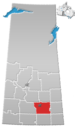
| Region | Southwest Saskatchewan |
| Census division | 6 |
| Rural Municipality | Abernethy |
| Established | 1880s |
| Government | |
| • Administrator | Thom Barker |
| • Governing body | Abernethy No. 186 |
| Time zone | CST |
| Postal code | S0A 0A0 |
| Area code(s) | 306 |
| Historic Sites | Kenlis United Church |
| [1][2][3][4] | |
Kenlis is a small farming community in Abernethy Rural Municipality No. 186, Saskatchewan, Canada. The community is located 10 km south of the village of Abernethy close to the Qu'appelle Valley on range road 112 about 15 km northeast of the town of Indian Head.
History
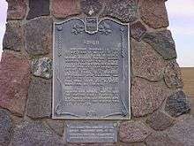

When the Canadian Pacific Railway constructed tracks through the village of Abernethy many residents and businesses from Kenis moved to be closer to the rail line. The Kenlis United Church and a Cairn Memorial to the school are still located on the former town site. Every summer the congregation from the United Church in Abernethy have a service in the old Kenlis Church. The Kenlis cemetery also still exists approximately two miles to the north with occasional burials still taking place.
See also
References
- ↑ National Archives, Archivia Net, Post Offices and Postmasters, archived from the original on 2006-10-06
- ↑ Government of Saskatchewan, MRD Home, Municipal Directory System, archived from the original on November 21, 2008
- ↑ Canadian Textiles Institute. (2005), CTI Determine your provincial constituency, archived from the original on 2007-09-11
- ↑ Commissioner of Canada Elections, Chief Electoral Officer of Canada (2005), Elections Canada On-line, archived from the original on 2007-04-21
External links
- Saskatchewan City & Town Maps
- Regional GenWeb site (Southwest Region)
- Saskatchewan Gen Web - One Room School Project
- Post Offices and Postmasters - ArchiviaNet - Library and Archives Canada
- Saskatchewan Gen Web Region
- Online Historical Map Digitization Project
- GeoNames Query
- Saskatchewan Cemetery Records
- Sask Cemeteries by Community and RM RM No. 186 - ABERNETHY
Places adjacent to Kenlis, Saskatchewan | ||||||||||
|---|---|---|---|---|---|---|---|---|---|---|
| ||||||||||