Lebret
| Lebret | |
|---|---|
| Village | |
| Village of Lebret | |
 Sacred Heart Roman Catholic Church | |
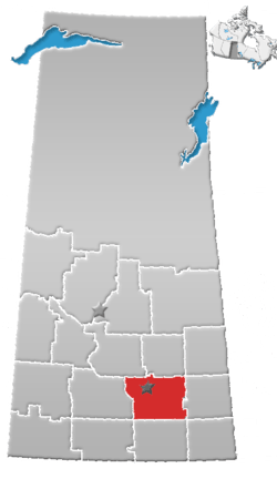
 Lebret Location of Lebret in Saskatchewan  Lebret Lebret (Canada) | |
| Coordinates: 50°45′25.66″N 103°42′10.20″W / 50.7571278°N 103.7028333°W | |
| Country |
|
| Province |
|
| Region | South-central |
| Census division | 6 |
| Rural Municipality | North Qu'Appelle No. 187 |
| Post office founded | 1880 |
| Incorporated (Village) | 1912 |
| Government | |
| • Type | Municipal |
| • Governing body | Lebret Village Council[1] |
| • Mayor | Ralph Blondeau |
| • Administrator | Caroline MacMurchy |
| Area | |
| • Total | 1.31 km2 (0.51 sq mi) |
| Population (2016) | |
| • Total | 216 |
| • Density | 165.3/km2 (428/sq mi) |
| Time zone | UTC-6 (CST) |
| Postal code | S0G 2Y0 |
| Area code(s) | 306 |
| Highways |
|
| Waterways |
Katepwa Lake Mission Lake |
| [2][3][4][5] | |
Lebret is a village within the rural municipality of North Qu'Appelle No. 187, in the province of Saskatchewan, Canada. The village is situated on Mission Lake in the Qu'Appelle Valley. The population was 216 at the 2016 Census, (a 8.4% increase from 199 in the 2011 Canada Census). Lebret is located along Highway 56, about 70 km (43 mi) northeast of the capital, Regina. The village was named after "the parish priest, Father Louis Lebret, who became the first postmaster of the community and, although he only held the position for a little more than six months, the office was named Lebret and the name became that of the community."[6]
History

The site of Lebret first came to non-First Nations outside attention in 1814 when Abbé Provencher visited. A further such visit occurred when Abbé Picard from Pembina arrived in 1841 and wintered with John McDonald, previously of the North-West Company;[7] the next record of visit is of Bishop Taché passing through in 1864 en route to Ile á la Crosse, returning with a party and staying in Fort Qu’Appelle and choosing the site which later became the village of Lebret for the Catholic mission, established the next year in 1866 as one of the earliest in what became the Province of Saskatchewan in 1905.[7]
It "became the main centre of Catholicism for the Métis and First Nations people in the region and a base for Oblate priests who travelled the southern plains to points such as Wood Mountain and the Cypress Hills."[6] The federal government financed the Qu'Appelle Indian Residential School in Lebret. which started in 1884 and run by the Missionary Oblates of Mary Immaculate. The first post office was opened in 1886, named Lebret which was given to the community. The Sisters of Our Lady of the Missions arrived in 1899 and founded Saint Gabriel’s Convent in 1906.[6]
The village was incorporated in 1912 and the fieldstone Sacred Heart Church built in 1925.[6] Churchgoing vastly waned among the Baby-Boom Generation to all but fundamentalist denominations beginning in the mid-1960s but full-house concerts were held in Sacred Heart Church by choirs of the nearby Saskatchewan Summer School of the Arts in Fort San. This ceased when the Summer School closed in 1991 due to lack of funding.[8]

In 1929 the landmark stations of the cross and the small chapel shrine on the hill overlooking Lebret were erected. Until the latter half of the 20th century Lebret was an important religious and educational centre. In addition to the residential school and the convent, there was a public school, and the Oblates established a theological training centre, Sacred Heart Scholasticate, on the south side of Mission Lake.
The scholasticate closed in the 1960s, the convent in the 1970s and the public school in 1980, its pupils transferring to Fort Qu’Appelle. The residential school was signed over to a First Nations school board in October 1973, at a ceremony presided over by the then Minister of Indian Affairs, Jean Chrétien. The school, which eventually became known as White Calf Collegiate, closed in 1998.[6]
It is still stated, though with its continuing relevance not dwelled upon, that "French Canadians continued to supplement the Métis in the Qu’Appelle Valley" and that "[t]he mission at Lebret was established in 1866."[9][10]
Today, Lebret remains a picturesque, yet very quiet, community[6] with Fort Qu'Appelle now relatively unique in retaining its vitality and even sometimes increasing in population while other towns once of equal significance and size steadily dwindle in population and economic activity.
Demograghics
| Canada census – Lebret community profile | |||
|---|---|---|---|
| 2016 | 2011 | 2006 | |
| Population: | 216 (8.5% from 2011) | 218 (7.4% from 2006) | 203 (-1.9% from 2001) |
| Land area: | 1.31 km2 (0.51 sq mi) | 1.32 km2 (0.51 sq mi) | 1.32 km2 (0.51 sq mi) |
| Population density: | 165.3/km2 (428/sq mi) | 165.5/km2 (429/sq mi) | 154.1/km2 (399/sq mi) |
| Median age: | 42.5 (M: 48.0, F: 37.5) | 47.6 (M: 51.0, F: 46.0) | 46.4 (M: 51.2, F: 44.0) |
| Total private dwellings: | 96 | 143 | 140 |
| Median household income: | |||
| References: 2016[11] 2011[12] 2006[13] earlier[14] | |||
Economy
Local businesses include Warren G's Grocery, Too Good to Be Threw, Calling Lakes Inn, Little Glass Hut, Route 56, an Antique store, and Red Road gift shop. At various times during the village's history, there were numerous businesses including a gas station, diner, grain elevator, pawn shop, ice cream store, and hardware store.[15]
Image gallery
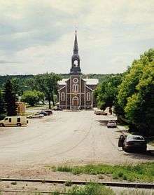 Sacred Heart Church Lebret showing street from highway
 The stations of the cross north of the village, across the highway
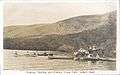 Como Park, now part of the resort village of Sandy Beach on Katepwa Lake, about five miles southeast of Lebret
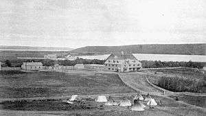 Qu'Appelle Industrial School in 1885. Parents camped outside the gate in order to visit their children. Destroyed by fire in 1904.
 This Qu'Appelle Industrial School built in 1905 replaced the one destroyed by fire the previous year. It, too, burned in 1932.
 Qu'Appelle Industrial School was built in 1905 to replace one destroyed by fire the previous year. It, too, burned in 1932.
See also
References
- ↑ Lebret Village Council
- ↑ National Archives, Archivia Net, Post Offices and Postmasters, archived from the original on 2006-10-06
- ↑ Government of Saskatchewan, MRD Home, Municipal Directory System, archived from the original on November 21, 2008
- ↑ Canadian Textiles Institute. (2005), CTI Determine your provincial constituency, archived from the original on 2007-09-11
- ↑ Commissioner of Canada Elections, Chief Electoral Officer of Canada (2005), Elections Canada On-line, archived from the original on 2007-04-21
- 1 2 3 4 5 6 http://esask.uregina.ca/entry/lebret.html David McLennan, "Lebret" in The Encyclopedia of Saskatchewan. Viewed 14 October 2012.
- 1 2 "Archived copy". Archived from the original on 2006-10-20. Retrieved 2006-10-16. "A Short History of Fort Qu'Appelle and Area," "Lebret." Viewed 14 October 2012.
- ↑ Qu'Appelle - Stories From the San
- ↑ http://esask.uregina.ca/entry/french_settlements.html Alan Anderson, "French Settlements" in The Encyclopedia of Saskatchewan. Viewed 14 October 2012.
- ↑ Adamson, Julia (16 Feb 2013). "Saskatchewan Roman Catholic Churches ~ Online Parish Registers ~ History". Saskatchewan Gen Web. Ancestry.com. Retrieved 2013-02-16.
- ↑ "2016 Community Profiles". Canada 2016 Census. Statistics Canada. February 21, 2017. Retrieved 2017-03-15.
- ↑ "2011 Community Profiles". Canada 2011 Census. Statistics Canada. July 5, 2013. Retrieved 2012-12-23.
- ↑ "2006 Community Profiles". Canada 2006 Census. Statistics Canada. March 30, 2011. Retrieved 2012-12-23.
- ↑ "2001 Community Profiles". Canada 2001 Census. Statistics Canada. February 17, 2012.
- ↑ Population and Dwelling Counts, for Canada and Census Subdivisions (Municipalities), 2001 and 1996 Censuses - 100% Data
External links
- Lebret Bar on Sask Bar Guide
- Lebret - Encyclopedia of Saskatchewan
- Saskatchewan City & Town Maps
- Regional GenWeb site (Southwest Region)
- Saskatchewan Gen Web - One Room School Project
- Post Offices and Postmasters - ArchiviaNet - Library and Archives Canada
- Saskatchewan Gen Web Region
- Online Historical Map Digitization Project
- GeoNames Query
- 2006 Community Profiles
- Saskatchewan Cemetery Records
- Sask Cemeteries by Community and RM RM No. 187 - NORTH QU'APELLE
- Statistics Canada
Places adjacent to Lebret | ||||||||||
|---|---|---|---|---|---|---|---|---|---|---|
| ||||||||||
| Subdivisions | |
|---|---|
| Communities | |
| Cities | |
| Topics |
|
| |