Disley, Saskatchewan
| Disley | |
|---|---|
| Village | |
| Village of Disley | |
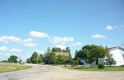 First Street, Disley | |
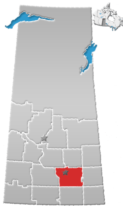
 Disley Location of Disley in Saskatchewan  Disley Disley (Canada) | |
| Coordinates: 50°39′14″N 105°00′39″W / 50.65389°N 105.01083°W | |
| Country |
|
| Province |
|
| Region | Southeast |
| Census division | 6 |
| Rural Municipality | Lumsden No. 189 |
| Post office Founded | 1904-04-01 |
| Government | |
| • Type | Municipal |
| • Governing body | Village Council |
| • Mayor | Gord Wilson |
| • Administrator | Rhonda Woelk |
| Area | |
| • Total | 0.65 km2 (0.25 sq mi) |
| Population (2016) | |
| • Total | 67 |
| • Density | 102.8/km2 (266/sq mi) |
| Time zone | UTC-6 (CST) |
| Postal code | S0G 3C0 |
| Area code(s) | 306 |
| Highways |
|
| Railways | Canadian National Railway |
| [1][2][3] | |
Disley is a village within the Rural Municipality of Lumsden No. 189 in the province of Saskatchewan, Canada. It is located 18 kilometres west of Lumsden just south of the Louis Riel Trail (Highway 11) and 48 kilometres north-west of the provincial capital city of Regina. The village had a population of 67 in the 2016 Census, (a 10.7% decrease from 75 in the 2011 Census).
Demographics
| Canada census – Disley, Saskatchewan community profile | |||
|---|---|---|---|
| 2016 | 2011 | 2006 | |
| Population: | 67 (-10.7% from 2011) | 111 (+79.0% from 2006) | 62 (0.0% from 2001) |
| Land area: | 0.65 km2 (0.25 sq mi) | 0.65 km2 (0.25 sq mi) | 0.65 km2 (0.25 sq mi) |
| Population density: | 102.8/km2 (266/sq mi) | 170.3/km2 (441/sq mi) | 95.1/km2 (246/sq mi) |
| Median age: | 39.8 (M: 42.0, F: 39.2) | 45.9 (M: 50.5, F: 45.5) | 39.2 (M: 44.2, F: 30.5) |
| Total private dwellings: | 33 | 43 | 32 |
| Median household income: | |||
| Notes: Some of the 2011 figures are from Statistics Canada's 2011 census corrections and updates.[4] – References: 2016[5] 2011[6] 2006[7] earlier[8] | |||
See also
References
- ↑ National Archives, Archivia Net. "Post Offices and Postmasters". Archived from the original on 2006-10-06. Retrieved 2014-08-21.
- ↑ Government of Saskatchewan, MRD Home. "Municipal Directory System". Archived from the original on 2016-01-15. Retrieved 2014-08-21.
- ↑ Commissioner of Canada Elections, Chief Electoral Officer of Canada (2005), Elections Canada On-line, archived from the original on 2007-04-21
- ↑ "Corrections and updates". Statistics Canada. 2012-05-29. Retrieved 2012-06-24.
- ↑ "2016 Community Profiles". Canada 2016 Census. Statistics Canada. February 21, 2017. Retrieved 2017-03-15.
- ↑ "2011 Community Profiles". Canada 2011 Census. Statistics Canada. July 5, 2013. Retrieved 2014-08-24.
- ↑ "2006 Community Profiles". Canada 2006 Census. Statistics Canada. March 30, 2011. Retrieved 2009-02-24.
- ↑ "2001 Community Profiles". Canada 2001 Census. Statistics Canada. February 17, 2012.
External links
Places adjacent to Disley, Saskatchewan | ||||||||||
|---|---|---|---|---|---|---|---|---|---|---|
| ||||||||||
| Subdivisions | |
|---|---|
| Communities | |
| Cities | |
| Topics |
|
| |
Coordinates: 50°36′54″N 105°05′42″W / 50.615°N 105.095°W
This article is issued from
Wikipedia.
The text is licensed under Creative Commons - Attribution - Sharealike.
Additional terms may apply for the media files.