Bethune, Saskatchewan
| Bethune | |
|---|---|
| Village | |
| Village of Bethune | |
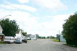 Main Street Bethune | |
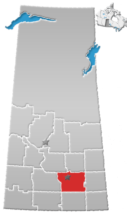
 Bethune Location of Bethune in Saskatchewan | |
| Coordinates: 50°43′N 105°13′W / 50.717°N 105.217°WCoordinates: 50°43′N 105°13′W / 50.717°N 105.217°W | |
| Country | Canada |
| Province | Saskatchewan |
| Region | Southwest |
| Census division | 6 |
| Rural Municipality | Dufferin No. 190 |
| Post office Founded | 1905-06-05 |
| Incorporated (Village) | 1912 |
| Government | |
| • Type | Municipal |
| • Governing body | Bethune Village Council |
| • Mayor | Derek Shaw[1] |
| • Administrator | Rodney Audette |
| Area | |
| • Total | 1.04 km2 (0.40 sq mi) |
| Population (2016)[2] | |
| • Total | 399 |
| • Density | 383.1/km2 (992/sq mi) |
| Time zone | UTC-6 (Central) |
| Postal code | S0G 0H0 |
| Area code(s) | 306 |
| Highways |
Hwy 642 |
| Website |
www |
| [3][4] | |
The village of Bethune lies within the RM Dufferin No. 190, province of Saskatchewan, Canada. The village is 56 km northwest of Regina on Highway 11 which is now designated as the Louis Riel Trail.[5] The population of Bethune is 400 people. Bethune is nestled amidst some beautiful waterways. Arm River flows along a river valley north of Bethune and features picturesque camping sites, and the Qu'Appelle River is a short way south. Last Mountain Lake or Long Lake is northeast of Bethune whereas Buffalo Pound Lake is just southwest.
The post office of Bethune, Assiniboia, NWT was established 5 June 1905, three months before Saskatchewan became a province. The village takes its name from C.B. Bethune, the engineer on the first train to travel the railway in 1887.[6]
Recreational sites
Buffalo Pound Provincial Park is located within 19 km or 12 mi. Grandview Beach is also located 19 km or 12 mi from Bethune. Kedleston Beach is closer: 15 km or 9 mi from Bethune. Another conservation area named Regina Beach Recreation Site is located 19 km or 12 mi from Bethune.
The Gillis Blakley Bethune and District Heritage Museum is a Municipal Heritage Property on the Canadian Register of Historic Places.[7]
Publications
Title Wagon trails to blacktop Published Bethune, Sask: Bethune & District Historical Society, 1983 Note Subtitle on spine: A history of Bethune and district Other Authors Bethune & District Historical Society Other Titles History of Bethune and district ISBN 0-919845-12-6[8]
Demographics
| ||||||||||||||||||||||||||||||||||||
Area statistics
- Lat (DMS) 50° 43' 00" N
- Long (DMS) 105° 13' 00" W
- Dominion Land Survey Sec.24, Twp.20, R.24, W of the 2nd meridian
- Time zone (cst) UTC−6
See also
References
- ↑ Administration & Governance
- ↑ "2011 Community Profiles". Statistics Canada. Government of Canada. Retrieved 2014-08-21.
- ↑ National Archives, Archivia Net. "Post Offices and Postmasters". Archived from the original on 2006-10-06. Retrieved 2014-08-21.
- ↑ Government of Saskatchewan, MRD Home. "Municipal Directory System". Archived from the original on 2016-01-15. Retrieved 2014-08-21.
- ↑ http://www.villageofbethune.com/
- ↑ Village of Bethune
- ↑ "Archived copy". Archived from the original on 2012-02-24. Retrieved 2009-01-06. Canadian Register of Historic Places.
- ↑ WebPAC PRO © Innovative Interfaces, Inc., University of Saskatchewan Online Library Database, retrieved 2007-08-06
- ↑ "2016 Community Profiles". Canada 2016 Census. Statistics Canada. February 21, 2017.
- ↑ "2011 Community Profiles". Canada 2011 Census. Statistics Canada. July 5, 2013. Retrieved 2011-02-24.
- ↑ "2006 Community Profiles". Canada 2006 Census. Statistics Canada. March 30, 2011. Retrieved 2009-02-24.
- ↑ "2001 Community Profiles". Canada 2001 Census. Statistics Canada. February 17, 2012.
External links
- VillageofBethune.com - Official site of Bethune
- Saskatchewan City & Town Maps
- Saskatchewan Gen Web - One Room School Project
- Post Offices and Postmasters - ArchiviaNet - Library and Archives Canada
- Saskatchewan Gen Web Region
- Online Historical Map Digitization Project
- GeoNames Query
- 2006 Community Profiles
- Municipal Directory System
Places adjacent to Bethune, Saskatchewan | |
|---|---|
| Subdivisions | |
|---|---|
| Communities | |
| Cities | |
| Topics |
|
| |