County Durham
| County Durham | |||
|---|---|---|---|
| County | |||
| |||
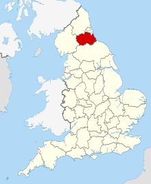 County Durham in England | |||
| Sovereign state |
| ||
| Country |
| ||
| Region | North East England | ||
| Established | Ancient | ||
| Ceremonial county | |||
| Lord Lieutenant | Susan Snowdon | ||
| High Sheriff | Dr Stephen Michael Cronin (2018/19)[1] | ||
| Area | 2,721 km2 (1,051 sq mi) | ||
| • Ranked | 18th of 48 | ||
| Population (mid-2017 est.) | 862,600 | ||
| • Ranked | 26th of 48 | ||
| Density | 322/km2 (830/sq mi) | ||
| Unitary authority | |||
| Council | Durham County Council | ||
| Executive | Labour | ||
| Admin HQ | Durham | ||
| Area | 2,226 km2 (859 sq mi) | ||
| • Ranked | 6th of 326 | ||
| Population | 523,700 | ||
| • Ranked | 7th of 326 | ||
| Density | 235/km2 (610/sq mi) | ||
| ISO 3166-2 | GB-DUR | ||
| ONS code | 00EJ | ||
| GSS code | E06000047 | ||
| NUTS | UKC14 | ||
| Website |
www | ||
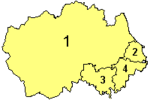 Districts of County Durham Unitary | |||
| Districts |
* only the part of the borough north of the River Tees is within the ceremonial county of Durham. | ||
| Members of Parliament | List of MPs | ||
| Police |
Durham Constabulary Cleveland Police (part) | ||
| Time zone | Greenwich Mean Time (UTC) | ||
| • Summer (DST) | British Summer Time (UTC+1) | ||
County Durham (/ˈdʌrəm/, locally /ˈdɜːrəm/)[N 1] is a county in North East England.[2] The county town is Durham, a cathedral city. The largest settlement is Darlington, closely followed by Hartlepool and Stockton-on-Tees. It borders Tyne and Wear to the north east, Northumberland to the north, Cumbria to the west and North Yorkshire to the south.[3] The county's historic boundaries stretch between the rivers Tyne and Tees, thus including places such as Gateshead, Jarrow, South Shields and Sunderland.
During the Middle Ages, the county was an ecclesiastical centre, due largely to the presence of St Cuthbert's shrine in Durham Cathedral, and the extensive powers granted to the Bishop of Durham as ruler of the County Palatine of Durham. The county has a mixture of mining, farming and heavy railway heritage, with the latter especially noteworthy in the southeast of the county, in Darlington, Shildon and Stockton [4] It is an area of regeneration and promoted as a tourist destination; in the centre of the city of Durham, Durham Castle and Durham Cathedral are UNESCO-designated World Heritage Sites.
Etymology
Many counties are named after their principal town, and the expected form here would be Durhamshire, but this form has never been in common use. The ceremonial county is officially named Durham,[3] but the county has long been commonly known as County Durham and is the only English county name prefixed with "County" in common usage (the practice is common in Ireland). Its unusual naming (for an English shire) is explained to some extent by the relationship with the Bishops of Durham, who for centuries governed Durham as a county palatine (the County Palatine of Durham), outside the usual structure of county administration in England.
The situation regarding the formal name in modern local government is less clear. The structural change legislation[5] which in 2009 created the present unitary council (that covers a large part – but not all – of the ceremonial county) refers to "the county of County Durham" and names the new unitary district "County Durham" too. However, a later amendment to that legislation,[6] refers to the "county of Durham" and the amendment allows for the unitary council to name itself "The Durham Council". In the event the council retained the name of Durham County Council. With either option, the name does not include County Durham.
The former postal county was named "County Durham" to distinguish it from the post town of Durham.
Politics
Local government
The ceremonial county of Durham is administered by four unitary authorities. The ceremonial county has no administrative function, but remains the area to which the Lord Lieutenant of Durham and the High Sheriff of Durham are appointed.
- County Durham (governed by Durham County Council): the unitary district was formed on 1 April 2009 replacing the previous two-tier system of a county council providing strategic services and seven district councils providing more local facilities. It has 126 councillors. The seven districts abolished were:[7][8]
- Chester-le-Street, including the Lumley, Pelton and Sacriston areas
- Derwentside, including Consett and Stanley
- City of Durham, including Durham city and the surrounding areas
- Easington, including Seaham and the new town of Peterlee
- Borough of Sedgefield, including Spennymoor and Newton Aycliffe
- Teesdale, including Barnard Castle and the villages of Teesdale
- Wear Valley, including Bishop Auckland, Crook, Willington, Hunwick, and the villages along Weardale
- The Borough of Darlington: before 1 April 1997, Darlington was a district in a two-tier arrangement with Durham County Council.[9]
- The Borough of Hartlepool: until 1 April 1996 the borough was one of four districts in the relatively short-lived county of Cleveland, which was abolished.[3][10]
- The part of the Borough of Stockton-on-Tees that is north of the centre of the River Tees. Stockton was also part of Cleveland until that county's abolition in 1996.[10] The remainder of the borough is part of the ceremonial county of North Yorkshire.[3]
Civil parishes
The county is partially parished.
Emergency services
Durham Constabulary operate in the area of the two unitary districts of County Durham and Darlington.[11] Ron Hogg was first elected the Durham Police and Crime Commissioner for the force on 15 November 2012. The other areas in the ceremonial county fall within the police area of the Cleveland Police.
Fire service areas follow the same areas as the police with County Durham and Darlington Fire and Rescue Service serving the two unitary districts of County Durham and Darlington and Cleveland Fire Brigade covering the rest. County Durham and Darlington Fire and Rescue Service is under the supervision of a combined fire authority consisting of 25 local councillors: 21 from Durham County Council and 4 from Darlington Borough Council.[12]
The North East Ambulance Service NHS Trust are responsible for providing NHS ambulance services throughout the ceremonial county, plus the boroughs of Middlesbrough and Redcar and Cleveland, which are south of the River Tees and therefore in North Yorkshire, but are also part of the North East England region.
Air Ambulance services are provided by the Great North Air Ambulance. The charity operates 3 helicopters including one at Durham Tees Valley Airport covering the County Durham area.
Teesdale and Weardale Search and Mountain Rescue Team, are based at Sniperly Farm in Durham City and respond to search and rescue incidents in the county.
History
County Palatine of Durham
The territory that became known as County Durham, originally a liberty under the control of the Bishops of Durham, had various names: the "Liberty of Durham", "Liberty of St Cuthbert's Land" "the lands of St. Cuthbert between Tyne and Tees" or "the Liberty of Haliwerfolc".[13]
The bishops' special jurisdiction rested on claims that King Ecgfrith of Northumbria had granted a substantial territory to St Cuthbert on his election to the see of Lindisfarne in 684. In about 883 a cathedral housing the saint's remains was established at Chester-le-Street and Guthfrith, King of York granted the community of St Cuthbert the area between the Tyne and the Wear. In 995 the see moved again, to Durham.

Following the Norman invasion, the administrative machinery of government extended only slowly into northern England. Northumberland's first recorded Sheriff was Gilebert from 1076 until 1080 and a 12th-century record records Durham regarded as within the shire.[14] However the bishops disputed the authority of the sheriff of Northumberland and his officials, despite the second sheriff for example being the reputed slayer of Malcolm Canmore, King of Scots. The crown regarded Durham as falling within Northumberland until the late thirteenth century. Matters came to a head in 1293 when the bishop and his steward failed to attend proceedings of quo warranto held by the justices of Northumberland. The bishop's case went before parliament, where he stated that Durham lay outside the bounds of any English shire and that "from time immemorial it had been widely known that the sheriff of Northumberland was not sheriff of Durham nor entered within that liberty as sheriff. . . nor made there proclamations or attachments".[15] The arguments appear to have prevailed, as by the fourteenth century Durham was accepted as a liberty which received royal mandates direct. In effect it was a private shire, with the bishop appointing his own sheriff.[13] The area eventually became known as the "County Palatine of Durham".
Sadberge was a liberty, sometimes referred to as a county, within Northumberland. In 1189 it was purchased for the see but continued with a separate sheriff, coroner and court of pleas. In the 14th century Sadberge was included in Stockton ward and was itself divided into two wards. The division into the four wards of Chester-le-Street, Darlington, Easington and Stockton existed in the 13th century, each ward having its own coroner and a three-weekly court corresponding to the hundred court. The diocese was divided into the archdeaconries of Durham and Northumberland. The former is mentioned in 1072, and in 1291 included the deaneries of Chester-le-Street, Auckland, Lanchester and Darlington.
The term palatinus is applied to the bishop in 1293, and from the 13th century onwards the bishops frequently claimed the same rights in their lands as the king enjoyed in his kingdom.
Early administration
The historic boundaries of County Durham included a main body covering the catchment of the Pennines in the west, the River Tees in the south, the North Sea in the east and the Rivers Tyne and Derwent in the north.[16][17] The county palatinate also had a number of liberties: the Bedlingtonshire, Islandshire[18] and Norhamshire[19] exclaves within Northumberland, and the Craikshire exclave within the North Riding of Yorkshire. In 1831 the county covered an area of 679,530 acres (2,750.0 km2)[20] and had a population of 253,910.[21] These exclaves were included as part of the county for parliamentary electoral purposes until 1832, and for judicial and local-government purposes until the coming into force of the Counties (Detached Parts) Act 1844, which merged most remaining exclaves with their surrounding county. The boundaries of the county proper remained in use for administrative and ceremonial purposes until the 1972 Local Government Act.
Until the 15th century the most important administrative officer in the Palatinate was the steward. Other officers included the sheriff, the coroners, the Chamberlain and the chancellor. The palatine exchequer originated in the 12th century. The palatine assembly represented the whole county, and dealt chiefly with fiscal questions. The bishop's council, consisting of the clergy, the sheriff and the barons, regulated judicial affairs, and later produced the Chancery and the courts of Admiralty and Marshalsea.
A Norman army captured Durham city in 1069. A rebellion took place against the new Norman earl, Robert de Comines, who was killed (January 1069). However, County Durham largely missed the Harrying of the North (1069–1070) that the Normans designed to subjugate such rebellions.[22] The best remains of the Norman period include Durham Cathedral and the castle, and also some few parish churches, such as those at Pittington and Norton in Stockton. The Early English period has left the eastern portion of the cathedral, the churches of Darlington, Hartlepool, and St Andrew, Auckland, Sedgefield, and portions of a few other churches.
The prior of Durham ranked first among the bishop's barons. He had his own court, and almost exclusive jurisdiction over his men. There were ten palatinate barons in the 12th century, most importantly the Hyltons of Hylton Castle, the Bulmers of Brancepeth, the Conyers of Sockburne, the Hansards of Evenwood, and the Lumleys of Lumley Castle. The Nevilles owned large estates in the county. John Neville, 3rd Baron Neville de Raby rebuilt Raby Castle, their principal seat, in 1377.
Edward I's quo warranto proceedings of 1293 showed twelve lords enjoying more or less extensive franchises under the bishop. The repeated efforts of the Crown to check the powers of the palatinate bishops culminated in 1536 in the Act of Resumption, which deprived the bishop of the power to pardon offences against the law or to appoint judicial officers. Moreover, indictments and legal processes were in future to run in the name of the king, and offences to be described as against the peace of the king, rather than that of the bishop. In 1596 restrictions were imposed on the powers of the chancery, and in 1646 the palatinate was formally abolished. It was revived, however, after the Restoration, and continued with much the same power until 5 July 1836, when the Durham (County Palatine) Act 1836 provided that the palatine jurisdiction should in future be vested in the Crown.[23]
During the 15th-century Wars of the Roses, Henry VI passed through Durham. On the outbreak of the Great Rebellion in 1642 Durham inclined to support the cause of the Parliament, and in 1640 the high sheriff of the palatinate guaranteed to supply the Scottish army with provisions during their stay in the county. In 1642 the Earl of Newcastle formed the western counties into an association for the King's service, but in 1644 the palatinate was again overrun by a Scottish army, and after the Battle of Marston Moor (2 July 1644) fell entirely into the hands of the parliament.
In 1614 a bill was introduced in parliament for securing representation to the county and city of Durham and the borough of Barnard Castle. The bishop strongly opposed the proposal as an infringement of his palatinate rights, and the county was first summoned to return members to parliament in 1654. After the Restoration of 1660 the county and city returned two members each. In the wake of the Reform Act of 1832 the county returned two members for two divisions, and the boroughs of Gateshead, South Shields and Sunderland acquired representation. The boroughs of Darlington, Stockton and Hartlepool returned one member each from 1868 until the Redistribution Act of 1885.
Modern local government
The Municipal Corporations Act 1835 reformed the municipal boroughs of Durham, Stockton on Tees and Sunderland . In 1875 Jarrow was incorporated as a municipal borough,[24] as was West Hartlepool in 1887.[25] At a county level, the Local Government Act 1888 reorganised local government throughout England and Wales.[26] Most of the county came under control of the newly-formed Durham County Council in an area known as an administrative county. Not included were the county boroughs of Gateshead, South Shields and Sunderland. However, for purposes other than local government the administrative county of Durham and the county boroughs continued to form a single county to which the Crown appointed a Lord Lieutenant of Durham.
Over its existence, the administrative county lost territory, both to the existing county boroughs, and also because two municipal boroughs became county boroughs: West Hartlepool in 1902[25] and Darlington in 1915.[27] The county boundary with the North Riding of Yorkshire was adjusted in 1967: that part of the town of Barnard Castle historically in Yorkshire was added to County Durham,[28] while the administrative county ceded the portion of the Borough of Stockton-on-Tees in Durham to the North Riding.[29] In 1968, following the recommendation of the Local Government Commission, Billingham was transferred to the county borough of Teesside, in the North Riding.[30] In 1971 the population of the county - including all associated county boroughs (an area of 2,570 km2 (990 sq mi)[21]) - was 1,409,633, with a population outside the county boroughs of 814,396.[31]
In 1974 the Local Government Act 1972 abolished the administrative county and the county boroughs, reconstituting County Durham as a non-metropolitan county.[26][32] The reconstituted County Durham lost territory[33] to the north-east (around Gateshead, South Shields and Sunderland) to Tyne and Wear[34][35] and to the south-east (around Hartlepool) to Cleveland.[34][35] At the same time it gained the former area of Startforth Rural District from the North Riding of Yorkshire.[36] The area of the Lord Lieutenancy of Durham was also adjusted by the Act to coincide with the non-metropolitan county[37] (which occupied 3,019 km2 (1,166 sq mi) in 1981).[21]
In 1996, as part of the 1990s UK local government reform, Cleveland was abolished[38] and its districts were reconstituted as unitary authorities.[39] Hartlepool and Stockton-on-Tees (north of the River Tees) were returned to Durham for the purposes of Lord Lieutenancy. The change in area for Lord Lieutenancy purposes to reflect the abolition of Cleveland was confirmed by the Lieutenancies Act 1997.[3] Cleveland was adopted as a postal county in 1974 and by the time of its abolition, the Royal Mail had abandoned the use of postal counties altogether;[40] Since 1996 the use of a county address line is permitted but not mandatory and can be however a writer wishes.[40]
In 1997 Darlington became a unitary authority and was separated from the shire county.
As part of the 2009 structural changes to local government in England initiated by the Department for Communities and Local Government,[41] the seven district councils within the County Council area were abolished. The County Council assumed their functions and became a unitary authority. The changes came into effect on 1 April 2009.[5]
Modern national government
Geography
Geology
County Durham is underlain by Carboniferous rocks in the west. Permian and Triassic strata overlie these older rocks in the east. These sedimentary sequences have been cut by igneous dykes and sills.
Climate
| County Durham | ||||||||||||||||||||||||||||||||||||||||||||||||||||||||||||
|---|---|---|---|---|---|---|---|---|---|---|---|---|---|---|---|---|---|---|---|---|---|---|---|---|---|---|---|---|---|---|---|---|---|---|---|---|---|---|---|---|---|---|---|---|---|---|---|---|---|---|---|---|---|---|---|---|---|---|---|---|
| Climate chart (explanation) | ||||||||||||||||||||||||||||||||||||||||||||||||||||||||||||
| ||||||||||||||||||||||||||||||||||||||||||||||||||||||||||||
| ||||||||||||||||||||||||||||||||||||||||||||||||||||||||||||
The following climate figures were gathered at the Durham weather station between 1971 and 2000.
| ||||||||||||||||||||||||||||||||||||||||||||||||||||||||||||||||||||||||||||||||||||||||||||||||||||||||||||||||||||||||||||||||||||||||||||
Green belt
County Durham contains a small area of green belt in the north of the county, surrounding primarily the city of Durham, Chester-le-Street and other communities along the shared county border with Tyne and Wear, to afford a protection from the Wearside conurbation. There is a smaller portion of belt separating Urpeth, Ouston, Pelton, and Perkinsville from Birtley in Tyne and Wear. A further small segment by the coast separates Seaham from the Sunderland settlements of Beckwith Green and Ryhope. It was first drawn up in the 1990s.[47]
North Pennines
The county contains a sizeable area of the North Pennines, designated an Area of Outstanding Natural Beauty, primarily west of Tow Law and Barnard Castle.
Biology
Birds
152 species of birds are recorded as breeding; however, not all are considered regular breeders.[48]
Demography
Population
The Office for National Statistics estimated in 2016 that the Durham County Council area had a population of 522,100, the Borough of Darlington a population of 105,600, the Borough of Hartlepool a population of 92,800, and the part of the Borough of Stockton-on-Tees in County Durham (the other part being in North Yorkshire) a population of 137,300[N 2]. This gives the total estimated population of the ceremonial county at 857,800.[49][50]

At the 2001 Census, Easington and Derwentside districts had the highest proportion (around 99%) in the county council area of resident population who were born in the UK.[51] 13.2% of the county council area's residents rate their health as not good, the highest proportion in England.[52] This table shows the historic population of the current remit of Durham County Council between 1801 and 2001.
| Year | Population | Year | Population | Year | Population | ||
|---|---|---|---|---|---|---|---|
| 1801 | 1871 | 1941 | |||||
| 1811 | |||||||
| 1821 | |||||||
| 1831 | |||||||
| 1841 | |||||||
| 1851 | |||||||
| 1861 | |||||||
| Source: A Vision of Britain through Time.[53] | |||||||
Employment
The proportion of the population working in agriculture fell from around 6% in 1851 to 1% in 1951; currently less than 1% of the population work in agriculture.[21] There were 15,202 people employed in coal mining in 1841, rising to a peak of 157,837 in 1921.[21] As at 2001, Chester-le-Street district has the lowest number of available jobs per working-age resident (0.38%).[54]
Economy
Economic history

Legend
The economic history of the county centres round the growth of the mining industry, which at its heights employed almost the whole of the non-agricultural population, with large numbers of pit villages being founded throughout the county. Stephen possessed a mine in Durham which he granted to Bishop Pudsey, and in the same century colliers are mentioned at Coundon, Bishopwearmouth and Sedgefield. Cockfield Fell was one of the earliest Landsale collieries in Durham. Richard II granted to the inhabitants of Durham licence to export the produce of the mines, the majority being transported from the Port of Sunderland complex which was constructed in the 1850s.
Among other early industries lead-mining was carried on in the western part of the county, and mustard was extensively cultivated. Gateshead had a considerable tanning trade and shipbuilding was undertaken at Sunderland, which became the largest shipbuilding town in the world – constructing a third of Britain's tonnage.
Economic output
The chart and table summarise unadjusted gross value added (GVA) in millions of pounds sterling for County Durham across 3 industries at current basic prices from 1995 to 2004.
| Gross Value Added (GVA) (£m) | |||
|---|---|---|---|
| 1995 | 2000 | 2004 | |
| Agriculture, hunting and forestry | 45 | 33 | 48 |
| Industry, including energy and construction | 1,751 | 1,827 | 1,784 |
| Service activities | 2,282 | 2,869 | 3,455 |
| Total | 4,078 | 4,729 | 5,288 |
| UK | 640,416 | 840,979 | 1,044,165 |
Post markings
Postal Rates from 1801 were charged depending on the distance from London. Durham was allocated the code 263 the approximate mileage from London. From about 1811, a datestamp appeared on letters showing the date the letter was posted. In 1844 a new system was introduced and Durham was allocated the code 267. This system was replaced in 1840 when the first postage stamps were introduced.
Culture
The culture of coal mining found expression in the Durham Miners' Gala, which was first held in 1871,[56] developed around the culture of trade unionism. Coal mining continued to decline and pits closed. The UK miners' strike of 1984/5 caused many miners across the county to strike. Today no deep-coal mines exist in the county and numbers attending the Miners' Gala decreased over the period between the end of the strike and the 21st century. However recent years have seen numbers significantly grow, and more banners return to the Gala each year as former colliery communities restore or replicate former banners to march at the Gala parade.[56][57]
Individuals such as Tom Lamb have been able to turn their mining career into a career in art. Lamb's artworks depict scenes of life underground experienced daily by miners, through this people are able to understand and experience the mining culture of County Durham.
Settlements
Since the Local Government Act 1972, some settlements within the historic county boundaries now lie within other administrative counties. These include:
| Tyne and Wear | Birtley, Blaydon, Boldon, Felling, Gateshead, Hebburn, Houghton-le-Spring, Jarrow, Ryton, South Shields, Sunderland, Washington, Whickham |
|---|
However a small number of settlements, such as Startforth, are now included within County Durham as opposed to Yorkshire.
Education
Durham LEA has a comprehensive school system with 36 state secondary schools (not including sixth form colleges) and five independent schools (four in Durham and one in Barnard Castle). Easington district has the largest school population by year, and Teesdale the smallest with two schools. Only one school in Easington and Derwentside districts have sixth forms, with about half the schools in the other districts having sixth forms.
The University of Durham is based in Durham city and is sometimes held to be the third oldest university in England.[58]
Places of interest
| Key | |
| Abbey/Priory/Cathedral | |
| Accessible open space | |
| Amusement/Theme Park | |
| Castle | |
| Country Park | |
| English Heritage | |
| Forestry Commission | |
| Heritage railway | |
| Historic House | |
| Museum (free/not free) | |
| National Trust | |
| Theatre | |
| Zoo | |
- County Hall
- Apollo Pavilion, Peterlee, controversial piece of concrete art designed by Victor Pasmore in 1969.
- Auckland Castle, Bishop Auckland

- Barnard Castle


- Beamish Museum, in Stanley

.svg.png)

- Binchester Roman Fort
- Bowes Museum, in Barnard Castle
- Castle Eden, a castle with adjoining village, famous for the Castle Eden Brewery.
- Castle Eden Dene, Nature reserve with coal mining heritage.
- Causey Arch, near Stanley
- Crook Hall and Gardens
- Durham Cathedral and Castle, a World Heritage Site
- Durham Dales
- Durham Light Infantry Museum, Aykley Heads, Near Durham
- Escomb Saxon Church, near Bishop Auckland
- Finchale Priory, near Durham city
- Hamsterley Forest
- Hardwick Hall Country Park

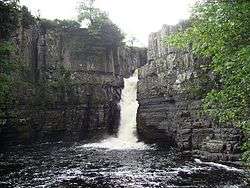
- High Force and Low Force waterfalls, on the River Tees
- Ireshopeburn – oldest Methodist chapel in the world to have held continuous services. Site of the 'Weardale Museum'
- Killhope Wheel, part of the North of England Lead Mining Museum in Weardale
- Longovicium Roman Fort, Lanchester – ruined auxiliary fort.
- Oriental Museum, Durham City – Asian artefacts and information.
- Raby Castle, near Staindrop
- Seaham Hall
- Sedgefield – St. Edmund's Church has notable Cosin woodwork. Home to Sedgefield Racecourse.
- Locomotion railway museum, in Shildon

- Tanfield Railway, in Tanfield
- Ushaw College, Catholic Seminary of great religious heritage.
- Weardale Railway, at Stanhope, County Durham, Wolsingham and Bishop Auckland
- North of England Institute of Mining and Mechanical Engineers, Newcastle
Surnames
Most common surnames in County Durham at the time of the United Kingdom Census of 1881,[59] by order of incidence:
See also
- List of Lord Lieutenants of Durham
- Custos Rotulorum of Durham – Keepers of the Rolls
- List of High Sheriffs of Durham
- County Durham (UK Parliament constituency) – Historical list of MPs for County Durham constituency
Notes
- ↑ the ceremonial county is formally named Durham – see Etymology
- ↑ the total estimated population of the Borough of Stockton-on-Tees (195,700) less the populations of the electoral wards of Ingleby Barwick East, Ingleby Barwick West, Mandale and Victoria, Stainsby Hill, Village, and Yarm
References

- ↑ "No. 62229". The London Gazette. 15 March 2018. pp. 4814–4814.
- ↑ North East Assembly – About North East England Archived 20 December 2007 at the Wayback Machine.. Retrieved 30 November 2007.
- 1 2 3 4 5 Lieutenancies Act 1997. Retrieved 27 October 2014.
- ↑ Durham County Council – History and Heritage of County Durham Archived 20 November 2007 at the Wayback Machine.. Retrieved 30 November 2007.
- 1 2 County Durham (Structural Change) Order 2008 Archived 23 April 2009 at the Wayback Machine.
- ↑ "The Local Government (Structural Changes) (Miscellaneous Amendments and Other Provision) Order 2009". legislation.gov.uk.
- ↑ "The County Durham (Structural Change) Order 2008". Office of Public Sector Information. 2008. Archived from the original on 23 April 2009. Retrieved 18 April 2009.
- ↑ Durham County Council – Districts of Durham map Archived 9 February 2009 at the Wayback Machine.. Retrieved 30 November 2007.
- ↑ "The Durham (Borough of Darlington) (Structural Change) Order 1995". Office of Public Sector Information. 1995. Archived from the original on 6 October 2008. Retrieved 18 April 2009.
- 1 2 "The Cleveland (Structural Change) Order 1995". Office of Public Sector Information. 1995. Archived from the original on 2 May 2009. Retrieved 18 April 2009.
- ↑ Durham Constabulary – Force Geography Archived 24 November 2007 at the Wayback Machine.. Retrieved 1 December 2007.
- ↑ "Combined Fire Authority". Durham and Darlington Fire and Rescue Authority. 25 February 2009. Archived from the original on 13 May 2011. Retrieved 18 April 2009.
- 1 2 Scammell, Jean (1966). "The Origin and Limitations of the Liberty of Durham". The English Historical Review. 81 (320): 449–473. JSTOR 561658.
- ↑ Warren, W. L. (1984). "The Myth of Norman Administrative Efficiency: The Prothero Lecture". Transactions of the Royal Historical Society. 34: 113–132. JSTOR 3679128.
- ↑ Fraser, C. M. (1956). "Edward I of England and the Regalian Franchise of Durham". Speculum. 31 (2): 329–342. doi:10.2307/2849417. JSTOR 2849417.
- ↑ Vision of Britain – Durham historic boundaries. Retrieved 30 November 2007.
- ↑ "History of County Durham | Map and description for the county, A Vision of Britain through Time". Vision of Britain. University of Portsmouth. Retrieved 19 October 2017.
- ↑ Vision of Britain – Islandshire Archived 29 April 2011 at the Wayback Machine. (historic map). Retrieved 1 December 2007.
- ↑ Vision of Britain – Norhamshire Archived 29 April 2011 at the Wayback Machine. (historic map). Retrieved 1 December 2007.
- ↑ Vision of Britain – Durham (Ancient): area. Retrieved 30 November 2007
- 1 2 3 4 5 National Statistics – 200 years of the Census in... Durham. Retrieved 2 December 2007.
- ↑ Douglas, D.C. William the Conqueror: The Norman Impact Upon England
- ↑ The Durham (County Palatine) Act 1836 (6 & 7 Will 4 c 19)
- ↑ Vision of Britain – Jarrow MB Archived 29 April 2011 at the Wayback Machine.. Retrieved 1 December 2007.
- 1 2 Vision of Britain – West Hartlepool MB/CB Archived 29 April 2011 at the Wayback Machine.. Retrieved 30 November 2007.
- 1 2 Bryne, T. (1994). Local Government in Britain. Penguin. ISBN 978-0-14-026739-6.
- ↑ Vision of Britain – Darlington MB/CB Archived 29 April 2011 at the Wayback Machine.. Retrieved 30 November 2007.
- ↑ Vision of Britain – Yorkshire, North Riding Archived 29 April 2011 at the Wayback Machine.. Retrieved 30 November 2007.
- ↑ Vision of Britain – Stockton on Tees Archived 29 April 2011 at the Wayback Machine.. Retrieved 30 November 2007.
- ↑ Vision of Britain – Billingham UD Archived 29 April 2011 at the Wayback Machine.. Retrieved 30 November 2007.
- ↑ UK Census, 1971
- ↑ Office for National Statistics (1999). Gazetteer of the old and new geographies of the United Kingdom. Office for National Statistics. ISBN 978-1-85774-298-5.
- ↑ Her Majesty's Stationery Office (1996). Aspects of Britain: Local Government. Stationery Office Books. ISBN 978-0-11-702037-5.
- 1 2 Arnold-Baker, C., Local Government Act 1972, (1973)
- 1 2 Young, F. (1991). Guide to Local Administrative Units of England: Northern England. Royal Historical Society. ISBN 978-0-86193-127-9.
- ↑ Durham County Council – About Us: Council Logo Archived 14 November 2007 at the Wayback Machine.. Retrieved 1 December 2007.
- ↑ Elcock, H., Local Government, (1994)
- ↑ OPSI – Cleveland (Structural Change) Order 1995 Archived 2 May 2009 at the Wayback Machine.. Retrieved 30 November 2007.
- ↑ OPSI – Cleveland (Further Provision) Order 1995 Archived 7 January 2008 at the Wayback Machine.. Retrieved 30 November 2007.
- 1 2 Royal Mail, Address Management Guide, (2004)
- ↑ Durham County Council – Local Government Review in County Durham Archived 14 May 2007 at the Wayback Machine.. Retrieved 30 November 2007.
- ↑ "Durham 1971–2000 averages". Met Office. Archived from the original on 29 September 2007. Retrieved 20 August 2007.
- ↑ "Durham climate information". Met Office. 1981–2010. Retrieved 11 August 2015.
- ↑ "Exceptional warmth, December 2015". Met Office. 27 January 2016. Retrieved 2017-10-19.
- ↑ Kendon, Mike; McCarthy, Mark; Jevrejeva, Svetlana; Legg, Tim (2015). "State of the UK Climate 2015" (PDF). Met Office. Retrieved 29 March 2018.
- ↑ "Local Extremes at Durham since 1850". North East Forum. 2004. Retrieved 29 March 2018.
- ↑ "PLANNING AND HIGHWAYS COMMITTEE 21 NOVEMBER 2012 THE COUNTY DURHAM PLAN, LOCAL PLAN PREFERED [sic] OPTIONS". www.sunderland.gov.uk.
- ↑ Bowey, K. and Newsome, M. (Ed) 2012. The Birds of Durham. Durham Bird Club. ISBN 978-1-874701-03-3
- ↑ "Population Estimates for UK, England and Wales, Scotland and Northern Ireland, Mid-2016". Office for National Statistics. 22 June 2017. Retrieved 15 November 2017.
- ↑ "Ward Level Mid-Year Population Estimates, Mid-2016". Office for National Statistics. 26 October 2017. Retrieved 15 November 2017.
- ↑ National Statistics – Census 2001 – Ethnicity and religion in England and Wales. Retrieved 2 December 2007.
- ↑ National Statistics – Health Of The Nation. Retrieved 2 December 2007.
- ↑ A Vision of Britain through time. "Durham: Total Population". Retrieved 1 December 2007.
- ↑ Hastings, D., Local area labour market statistical indicators incorporating the Annual Population Survey Archived 3 December 2007 at the Wayback Machine., National Statistics – Labour Market Trends, (2006). Retrieved 2 December 2007.
- ↑ "NUTS3 GVA (1995–2004) Data". Office for National Statistics. Archived from the original on 3 March 2005. Retrieved 31 August 2007.
- 1 2 Miner's Advice – Moving on seamlessly.... Retrieved 2 December 2007.
- ↑ Heritage Lottery Fund – Durham Miners' Gala Archived 28 September 2007 at the Wayback Machine.. Retrieved 2 December 2007.
- ↑ "About Durham University : Our history and values – Durham University". dur.ac.uk.
- ↑ Most Common Surnames in Durham
Further reading
- Samuel Tymms (1837). "Durham". Northern Circuit. The Family Topographer: Being a Compendious Account of the ... Counties of England. 6. London: J.B. Nichols and Son. OCLC 2127940.
External links
| Wikimedia Commons has media related to County Durham. |
| Wikisource has the text of a 1911 Encyclopædia Britannica article about County Durham. |
| Wikivoyage has a travel guide for County Durham. |
- County Durham at Curlie (based on DMOZ)
- Durham County Council
- Hotels in Co Durham
- One North East guides & brochures
- Guided Walks Programme from Durham County Councill
- Visit County Durham
- The North East Forum
- Images of Durham at the English Heritage Archive
- "Durham", Historical Directories, UK: University of Leicester
North East England Portal | |
| Unitary authorities | |
| Major settlements |
|
| Topics | |