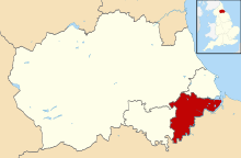
Borough of Stockton-on-Tees
| Borough of Stockton-on-Tees | ||
|---|---|---|
| Unitary, Borough | ||
| ||
 the part of Stockton-on-Tees within County Durham | ||
 the part of Stockton-on-Tees within North Yorkshire | ||
| Sovereign state | United Kingdom | |
| Constituent country | England | |
| Region | North East England | |
| City region | Tees Valley | |
| Ceremonial county | Durham and North Yorkshire | |
| Admin. HQ | Stockton-on-Tees | |
| Government | ||
| • Type | Stockton Borough Council | |
| • Leadership: | Leader & Cabinet | |
| • Executive: | Labour | |
| • Mayor | Councillor Kathryn Nelson[1] | |
| • MPs: |
Alex Cunningham (L) Paul Williams (L) | |
| Area | ||
| • Total | 79.2 sq mi (205.0 km2) | |
| Area rank | 164th | |
| Population (mid-2017 est.) | ||
| • Total | 196,500 | |
| • Rank | Ranked 90th | |
| • Density | 2,500/sq mi (960/km2) | |
| Time zone | UTC+0 (Greenwich Mean Time) | |
| • Summer (DST) | UTC+1 (British Summer Time) | |
| ONS code |
00EF (ONS) E06000004 (GSS) | |
| Ethnicity |
97.2% White 1.7% S.Asian | |
| Website | stockton.gov.uk | |
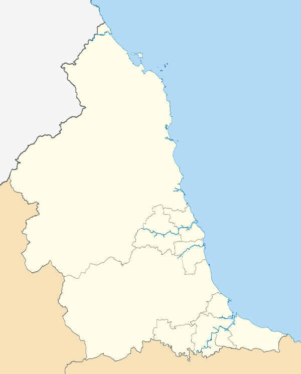
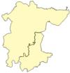
The Borough of Stockton-on-Tees is a unitary authority and borough in the north east of England, with a population of 191,600 shown in the 2011 census.[2] It is split between the ceremonial counties of Durham and North Yorkshire by the River Tees.
The borough of Stockton-on-Tees consists of Stockton-on-Tees (population 82,880), and smaller outlying settlements, including Billingham (pop. 36,720) also north of the Tees, while south of the river are Thornaby-on-Tees, (pop. 23,200), Yarm and Ingleby Barwick (pop. 16,280). Durham Tees Valley Airport is also partly within the borough. The Stockton-on-Tees borough accounts for the largest number of residents within the Teesside and Hartlepool urban area. Together with other neighbouring boroughs, it forms part of the Tees Valley city region.
History
The core of the town was anciently in County Durham, but the borough spilled over the river into Yorkshire. The borough was formed on 1 April 1974, from the Stockton part of Teesside county borough, along with part of Stockton Rural District in County Durham and part of Stokesley Rural District from the North Riding. At that time it was designated a non-metropolitan district of Cleveland.
It became a unitary authority on 1 April 1996. For ceremonial purposes the borough is split between County Durham and North Yorkshire, along the line of the River Tees as shown in the map (left) with County Durham to the north and North Yorkshire to the south. It is the only council area in England or Wales to be split between two ceremonial counties.
Council
The Borough has 26 wards with either one, two or three Councillors representing each. There are 56 Councillors in total in the Borough of Stockton. Following the elections that took place in May 2015, 32 Councillors are Labour, 13 Conservative, 5 Ingleby Barwick Independent Society, 3 Thornaby Independent Association, 2 West Words and 1 Liberal Democrat .[3]
Economy
This is a chart of trend of regional gross value added of Hartlepool and Stockton-on-Tees at current basic prices published (pp. 240–253) by Office for National Statistics with figures in millions of British Pounds Sterling.
| Year | Regional Gross Value Added4 | Agriculture1 | Industry2 | Services3 |
|---|---|---|---|---|
| 1995 | 2,804 | 9 | 1,443 | 1,352 |
| 2000 | 3,252 | 6 | 1,359 | 1,887 |
| 2003 | 3,364 | 6 | 1,037 | 2,320 |
^1 includes hunting and forestry
^2 includes energy and construction
^3 includes financial intermediation services indirectly measured
^4 Components may not sum to totals due to rounding
Local Nature Reserves
The council maintains a number of Local Nature Reserves including Barwick Pond, Charlton's Pond, Greenvale, Hardwick Dene and Elm Tree Woods, Norton Grange Marsh, Quarry Wood (Eaglescliffe) and Stillington Forest Park.
References
- ↑ "The Mayor – Stockton Borough Council". www.stockton.gov.uk. Archived from the original on 15 June 2009. Retrieved 2 July 2009.
- ↑ "Table P07 2011 Census: Number of usual residents living in households and communal establishments, local authorities in England and Wales". 2011 Census, Population and Household Estimates for England and Wales. Office for National Statistics. Retrieved 17 July 2012.
- ↑ "Councillors and Council Meeting Information (Egenda)". www.stockton.gov.uk. Archived from the original on 20 August 2009. Retrieved 2 July 2009.
External links
- Statistics about Stockton-on-Tees from the Office for National Statistics Census 2001
North East England Portal | |
| Unitary authorities | |
| Major settlements |
|
| Topics | |