Crook Hall, Durham
Crook Hall is a 14th-century Grade I listed manor house which stands off Sidegate in the Framwelgate area of the city of Durham. The House and Gardens are open for the public to view, Children's events and Weddings are held through the year, Afternoon Tea is very popular in the Georgian House and Gardens and there are two self-catering apartments on site.
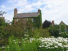
Built in sandstone with a Welsh slate roof, the oldest part dates from the 14th century. At one end is a 17th-century extension to which an 18th-century additional extension is attached, comprising 11 bays in all. It is surrounded by English country style gardens.[1]
History
The Manor of Sydgate was granted in 1217 to Aimery, son of the then Archdeacon of Durham, from whose family it passed to Peter del Croke, after whom it is named. From him it passed to the Billingham family, who occupied the hall for some 300 years. In 1657 it passed to the Mickletons until it was bought in 1736 by the Hoppers of Shincliffe. Since then there have been a succession of different owners until it was bought in a semi-derelict condition by the Cassels in 1928.[2]
The building is reputedly haunted by the "White Lady" and is open to the public throughout most of the year.
In more recent times, 1995, the property was bought by Keith and Maggie Bell who now open it to the public. It has become a major wedding venue, and visitors from around the world come to wander around the gardens as well as the Hall. The gardens are seen as one of the best in the north of the country.
Keith Bell has recently written a book called Blood, Sweat and Scones – two decades at Crook Hall ( ISBN 978-1-78803-528-6). In it he describes their period of ownership, and the trials and tribulations of owning a Grade-One listed building and creating a successful business/tourist attraction.
References
- ↑ Historic England. "CROOK HALL (1159909)". National Heritage List for England. Retrieved 26 July 2014.
- ↑ "A history of Croke or Crook Hall, Sydgate, Durham City". Archived from the original on 9 October 2012. Retrieved 26 July 2014.