Harderwijk
| Harderwijk | |||
|---|---|---|---|
| Municipality | |||
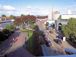 Harbour of Harderwijk seen from windmill De Hoop | |||
| |||
.svg.png) Location in Gelderland | |||
| Coordinates: 52°21′N 5°37′E / 52.350°N 5.617°ECoordinates: 52°21′N 5°37′E / 52.350°N 5.617°E | |||
| Country | Netherlands | ||
| Province | Gelderland | ||
| Government[1] | |||
| • Body | Municipal council | ||
| • Mayor | Harm-Jan van Schaik (CDA) | ||
| Area[2] | |||
| • Total | 48.27 km2 (18.64 sq mi) | ||
| • Land | 38.59 km2 (14.90 sq mi) | ||
| • Water | 9.68 km2 (3.74 sq mi) | ||
| Elevation[3] | 3 m (10 ft) | ||
| Population (August 2017)[4] | |||
| • Total | 46,694 | ||
| • Density | 1,210/km2 (3,100/sq mi) | ||
| Demonym(s) | Harderwijker | ||
| Time zone | UTC+1 (CET) | ||
| • Summer (DST) | UTC+2 (CEST) | ||
| Postcode | 3840–3849 | ||
| Area code | 0341 | ||
| Website |
www | ||

Harderwijk (![]()
It is served by the Harderwijk railway station.
Its population centres are Harderwijk and Hierden.
Harderwijk is on the western boundary of the Veluwe. The southeastern half of the municipality is largely forests.
History
Harderwijk received city rights from Count Otto II of Guelders in 1231.[5] A defensive wall surrounding the city was completed by the end of that century. The oldest part of the city is near where the streets Hoogstraat and Grote Poortstraat now are. Around 1315 the city was expanded southwards, which included the construction of what is now called the Grote Kerk (Great Church). A second, northward expansion took place around 1425.
Particularly along the west side of town, much of the wall still exists but often not in entirely original form. That also goes for the only remaining city gate, the Vischpoort (Fish Gate).
Between 1648 and 1811, the University of Harderwijk operated in the city. The Swedish botanist, physician and zoologist, Carl Linnaeus graduated at this university. The university, together with the universities of Zutphen and Franeker, was abolished by Napoleon.
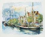
Harderwijk was a member of the Hanseatic League. It lies on what used to be the Zuiderzee shore (Southern Sea, now the IJsselmeer) and consequently its economy was strongly based on fishing and seafaring in general. That dramatically changed after 1932, when the Zuiderzee was cut off from the North Sea for safety reasons. Few fishing boats thus now remain in the Harbour, which now is home mainly to yachts. An annual event illustrating the former importantance of the fishing industry to Harderwijk is Aaltjesdag, which translates to Eel day. Fish can still be bought at stands and restaurants on the boulevard throughout the year except for the winter months. Tourists are common customers, but local people no longer make their living from the fisheries.
Today, Harderwijk is probably known best for the Dolfinarium Harderwijk, a marine mammal park where dolphin shows are held and various other marine mammals and fish are kept.
Notable residents
- Jan Bos (1975), speedskater
- Theo Bos (1983), cyclist
- Joost Eerdmans (1971), politician
- Theo de Meester (1851–1919), politician and prime minister
- Roef Ragas (1965–2007), actor
- Dirk Rijnders (1909–2006), politician
- Marco Roelofsen (1968), Dutch football (soccer) midfielder
- Richard Roelofsen (1969), Dutch football (soccer) striker
- Henk Schiffmacher (1952), tattoo artist
- Henk Timmer (1971), Dutch football (soccer) goalkeeper
Gallery
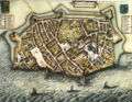 Map of Harderwijk (Blaeu's Toonneel der Steden, by Willem and Joan Blaeu, 1652. Note that north is at the bottom of the map.
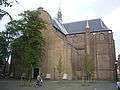 Harderwijk, church: de Grote Kerk
 Harderwijk, gate: de Vischpoort
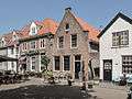 Harderwijk, view of a street: de Vischmarkt (Fish Market)
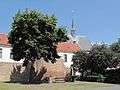 Harderwijk, defensive wall, cannon and church tower
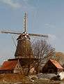 Harderwijk, windmill
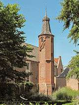 Harderwijk: het Linnaeustorentje (the Linnaeus tower)
References
Footnotes
- ↑ "Samenstelling" [Members] (in Dutch). Gemeente Harderwijk. Retrieved 17 June 2014.
- ↑ "Kerncijfers wijken en buurten" [Key figures for neighbourhoods]. CBS Statline (in Dutch). CBS. 2 July 2013. Retrieved 12 March 2014.
- ↑ "Postcodetool for 3841AA". Actueel Hoogtebestand Nederland (in Dutch). Het Waterschapshuis. Retrieved 17 June 2014.
- ↑ "Bevolkingsontwikkeling; regio per maand" [Population growth; regions per month]. CBS Statline (in Dutch). CBS. 27 October 2017. Retrieved 27 October 2017.
- ↑ Stenvert, R. et al. (2000). Monumenten in Nederland: Gelderland, p. 50 and 183–188. Zwolle: Waanders Uitgevers. ISBN 90-400-9406-3
Bibliography

External links

- Official website
Places adjacent to Harderwijk | ||||||||||
|---|---|---|---|---|---|---|---|---|---|---|
| ||||||||||
Members of the Hanseatic League by quarter | |||||
|---|---|---|---|---|---|
| |||||
| Wendish |
| 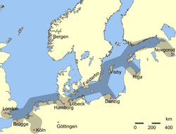  | |||
| Saxon | |||||
| Baltic | |||||
| Westphalian | |||||
| Kontore |
| ||||
| Other cities | |||||
