Zaltbommel
| Zaltbommel | |||
|---|---|---|---|
| Municipality | |||
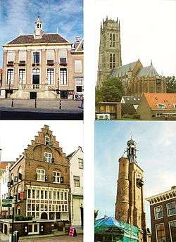 Clockwise from top left: City hall, Saint Martin church, Gasthuis Tower, Gothic house | |||
| |||
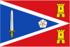
.svg.png) Location in Gelderland | |||
| Coordinates: 51°48′N 5°15′E / 51.800°N 5.250°ECoordinates: 51°48′N 5°15′E / 51.800°N 5.250°E | |||
| Country | Netherlands | ||
| Province | Gelderland | ||
| Government[1] | |||
| • Body | Municipal council | ||
| • Mayor | Peter Rehwinkel (acting) (PvdA) | ||
| Area[2] | |||
| • Total | 89.04 km2 (34.38 sq mi) | ||
| • Land | 79.61 km2 (30.74 sq mi) | ||
| • Water | 9.43 km2 (3.64 sq mi) | ||
| Elevation[3] | 3 m (10 ft) | ||
| Population (August 2017)[4] | |||
| • Total | 27,940 | ||
| • Density | 351/km2 (910/sq mi) | ||
| Time zone | UTC+1 (CET) | ||
| • Summer (DST) | UTC+2 (CEST) | ||
| Postcode | 5300–5311, 5315–5318 | ||
| Area code | 0418 | ||
| Website |
www | ||

Zaltbommel (Dutch pronunciation: [zɑltˈbɔməl] (![]()
Zaltbommel was expanded to its current size on 1 January 1999, by a merger of the municipalities of Brakel, Kerkwijk and Zaltbommel. The municipality is situated in the heart of the Netherlands, close to the A2 Motorway, the railway line from Utrecht to 's‑Hertogenbosch and the rivers Waal and Maas.
Topography
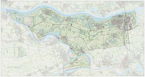
Dutch Topographic map of Zaltbommel (municipality), Sept. 2014
Population centres
The municipality, consists of 13 population centres and had a population of 27,940 in 2017.
| Name | Population (1-1-2015) |
Population (1-1-2016) |
|---|---|---|
| Aalst | 2102 | 2106 |
| Bern | 36 | 33 |
| Brakel | 3050 | 3066 |
| Bruchem | 1674 | 1668 |
| Delwijnen | 341 | 337 |
| Gameren | 2433 | 2466 |
| Kerkwijk | 629 | 640 |
| Nederhemert | 1612 | 1604 |
| Nieuwaal | 732 | 758 |
| Poederoijen | 1013 | 1039 |
| Zaltbommel | 12040 | 12143 |
| Zuilichem | 1704 | 1702 |
| Total | 27366 | 27562 |
The city of Zaltbommel
The town of Zaltbommel was first mentioned as "Bomela" in the year 850. Zaltbommel received city rights in 1231 and these were renewed in 1316. In 1599 during the Eighty Years War, Zaltbommel was besieged by Spanish forces but was relieved by an Anglo-Dutch force led by Maurice of Orange. The bridge over the Waal at Zaltbommel (which has since been replaced) features in a celebrated twentieth-century Dutch sonnet, De moeder de vrouw, by Martinus Nijhoff.[5]
Notable residents
- Maarten van Rossum, (ca. 1490–1555), military commander
- Lucas Vorsterman (1595–1675), engraver
- Gerard Hoet, (1648–1743) painter
- Hendrik Antonie Lodewijk Hamelberg (1826–1896), consul general and special envoy of the Orange Free State
- Sophie Pressburg (1797–1854), grandmother of Anton and Gerard Philips
- Suzanne Leenhoff (1829–1906), who married Édouard Manet at Zaltbommel on 28 October 1863[6]
- Gerard Philips (1858–1942), industrialist, co-founder of Philips Electronics
- Anton Philips (1874–1951), industrialist, co-founder of Philips Electronics
- Fiep Westendorp (1916-2004), illustrator
Image gallery
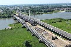 Zaltbommel (in the upper right-hand corner of the image) is situated on the banks of the Waal. Major north-south highways and railways cross the river in the town, just east of the town centre.
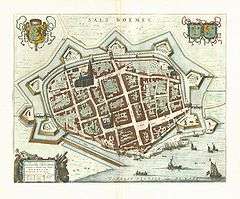 1649 map of Zaltbommel in Willem and Joan Blaeu's "Toonneel der Steden"
References
- ↑ "Burgemeester Van den Bosch" [Mayor Van den Bosch] (in Dutch). Gemeente Zaltbommel. Retrieved 24 July 2014.
- ↑ "Kerncijfers wijken en buurten" [Key figures for neighbourhoods]. CBS Statline (in Dutch). CBS. 2 July 2013. Retrieved 12 March 2014.
- ↑ "Postcodetool for 5301LB". Actueel Hoogtebestand Nederland (in Dutch). Het Waterschapshuis. Retrieved 24 July 2014.
- ↑ "Bevolkingsontwikkeling; regio per maand" [Population growth; regions per month]. CBS Statline (in Dutch). CBS. 27 October 2017. Retrieved 27 October 2017.
- ↑ Hollandse Gedichten http://home.kpn.nl/grumbl/gedichten/Hollandse%20gedichten/Hollandse%20gedichten.htm Retrieved 4 August 2017
- ↑ Streekarchief Bommelerwaard (Zaltbommel district archive, in Dutch) Retrieved 5 January 2017
External links

- Official website
Places adjacent to Zaltbommel | |
|---|---|
