Aalten
| Aalten | |||
|---|---|---|---|
| Municipality | |||
 Aalten town hall | |||
| |||
.svg.png) Location in Gelderland | |||
| Coordinates: 51°56′N 6°35′E / 51.933°N 6.583°ECoordinates: 51°56′N 6°35′E / 51.933°N 6.583°E | |||
| Country | Netherlands | ||
| Province | Gelderland | ||
| Government[1] | |||
| • Body | Municipal council | ||
| • Mayor | Anton Stapelkamp (CU) | ||
| Area[2] | |||
| • Total | 97.03 km2 (37.46 sq mi) | ||
| • Land | 96.51 km2 (37.26 sq mi) | ||
| • Water | 0.52 km2 (0.20 sq mi) | ||
| Elevation[3] | 31 m (102 ft) | ||
| Population (August 2017)[4] | |||
| • Total | 27,063 | ||
| • Density | 280/km2 (700/sq mi) | ||
| Demonym(s) | Aaltenaar | ||
| Time zone | UTC+1 (CET) | ||
| • Summer (DST) | UTC+2 (CEST) | ||
| Postcode | 7090–7095, 7120–7126 | ||
| Area code | 0315, 0543 | ||
| Website |
www | ||


Aalten (![]()
Notable inhabitants of Aalten include Angus Young, guitarist of the Australian rock band AC/DC, and Robert Gesink, a professional road bicycle racer. During World War II, 51 of Aalten's 85 Jews were hidden by local non-Jews, and thereby survived the war.[5] According to the War and Resistance Museum in Aalten, the village had the highest number of people in hiding during World War II. The village of approximately 13,000 residents hid some 2500 people.[6]
Population centres
- Aalten
- Barlo
- Bredevoort
- Dale
- De Heurne
- Dinxperlo
- Haart
- Heurne
- Hollenberg
- IJzerlo
- 't Klooster
- Lintelo
Transportation
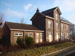
Aalten railway station serves Aalten and the surrounding area. There is a half-hourly service between Arnhem and Winterswijk, which stops at this station. Arnhem railway station has services to Amsterdam, Amsterdam Airport, Utrecht, Nijmegen, 's-Hertogenbosch, Breda, Tilburg and to cities in Germany.
Aalten also has an hourly bus service to Ruurlo and to Zelhem.
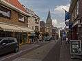
Gallery


References
- ↑ "Samenstelling college burgemeester en wethouders" [Mayor and Municipal Executive] (in Dutch). Gemeente Aalten. Retrieved 21 November 2017.
- ↑ "Kerncijfers wijken en buurten" [Key figures for neighbourhoods]. CBS Statline (in Dutch). CBS. 2 July 2013. Retrieved 12 March 2014.
- ↑ "Postcodetool for 7121CS". Actueel Hoogtebestand Nederland (in Dutch). Het Waterschapshuis. Archived from the original on 21 September 2013. Retrieved 18 June 2014.
- ↑ "Bevolkingsontwikkeling; regio per maand" [Population growth; regions per month]. CBS Statline (in Dutch). CBS. 27 October 2017. Retrieved 27 October 2017.
- ↑ Martin Gilbert, 'The Holocaust' (1986), page 376,
- ↑ http://www.marline.nl/verzet.html Archived 2014-02-19 at the Wayback Machine. 'Marline: de infozine v/d Achterhoek'
External links

- Official website
Places adjacent to Aalten | ||||||||||
|---|---|---|---|---|---|---|---|---|---|---|
| ||||||||||

| Authority control |
|---|