Overbetuwe
| Overbetuwe | |||
|---|---|---|---|
| Municipality | |||
_gemeentehuis.JPG) Overbetuwe town hall | |||
| |||
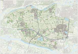
.svg.png) Location in Gelderland | |||
| Coordinates: 51°55′N 5°51′E / 51.917°N 5.850°ECoordinates: 51°55′N 5°51′E / 51.917°N 5.850°E | |||
| Country | Netherlands | ||
| Province | Gelderland | ||
| Established | 1 January 2001[1] | ||
| Government[2] | |||
| • Body | Municipal council | ||
| • Mayor | Toon van Asseldonk | ||
| Area[3] | |||
| • Total | 115.08 km2 (44.43 sq mi) | ||
| • Land | 109.36 km2 (42.22 sq mi) | ||
| • Water | 5.72 km2 (2.21 sq mi) | ||
| Elevation[4] | 10 m (30 ft) | ||
| Population (August 2017)[5] | |||
| • Total | 47,484 | ||
| • Density | 434/km2 (1,120/sq mi) | ||
| Time zone | UTC+1 (CET) | ||
| • Summer (DST) | UTC+2 (CEST) | ||
| Postcode | 6660–6662, 6665–6668, 6670–6678 | ||
| Area code | 026, 0481, 0488 | ||
| Website |
www | ||

Overbetuwe (![]()
Towns
| Town | Inhabitants (2015) |
|---|---|
| Andelst | 1650 |
| Driel | 4205 |
| Elst | 21554 |
| Hemmen | 184 |
| Herveld | 3015 |
| Heteren | 5109 |
| Homoet | 76 |
| Loenen | 47 |
| Oosterhout (partly) | 2337 |
| Randwijk | 1435 |
| Slijk-Ewijk | 479 |
| Valburg | 1780 |
| Zetten | 5002 |
Transportation
Because of its central location between the cities of Nijmegen and Arnhem, many inhabitants of Overbetuwe commute between these cities. Three major highways are situated in the municipality; the A50, A15 and A325. Overbetuwe has two railway stations: Elst and Zetten-Andelst. Besides these two existing railway lines, a controversial freight line called the Betuweroute has been operational from 2007.
Politics
The gemeenteraad (city council) of Overbetuwe consists of 29 seats. Below is the composition of the city council since 2000:
| Gemeenteraadszetels | |||||||||||||||
|---|---|---|---|---|---|---|---|---|---|---|---|---|---|---|---|
| Partij | 2000 | 2006 | 2010 | 2014 | 2018[6] | ||||||||||
| CDA | 7 | 7 | 7 | 13 | 9 | ||||||||||
| PvdA | 3 | 6 | 4 | 1 | 2 | ||||||||||
| D66 | 4 | 3 | 5 | 5 | 4 | ||||||||||
| VVD | 3 | 3 | 5 | 2 | 3 | ||||||||||
| Gemeentebelangen | - | 5 | 5 | 4 | 4 | ||||||||||
| GroenLinks | 2 | 2 | 2 | 2 | 4 | ||||||||||
| ChristenUnie | 1 | 1 | 1 | 1 | 1 | ||||||||||
| Over-Betuwe Lokaal* | 3 | - | - | - | - | ||||||||||
| Dorpslijst Elst* | 2 | - | - | - | - | ||||||||||
| Burger Belangen Overbetuwe | - | - | - | 1 | 2 | ||||||||||
| SGP | - | - | - | - | - | ||||||||||
| Totaal | 27 | 27 | 29 | 29 | 29 | ||||||||||
Gallery
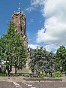 Elst, church: de Grote of Sint Maartenskerk
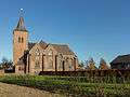 Zetten, church
 Driel, river: Rhine
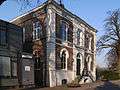 Heteren former townhall
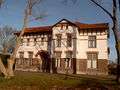 Zetten, het Witte Huis
 Herveld, windmill: molen de Vink
References
- ↑ "Gemeentelijke indeling op 1 januari 2001" [Municipal divisions on 1 January 2001]. cbs.nl (in Dutch). CBS. Retrieved 15 July 2014.
- ↑ "Samenstelling" [Members] (in Dutch). Gemeente Overbetuwe. Retrieved 15 July 2014.
- ↑ "Kerncijfers wijken en buurten" [Key figures for neighbourhoods]. CBS Statline (in Dutch). CBS. 2 July 2013. Retrieved 12 March 2014.
- ↑ "Postcodetool for 6661EH". Actueel Hoogtebestand Nederland (in Dutch). Het Waterschapshuis. Retrieved 15 July 2014.
- ↑ "Bevolkingsontwikkeling; regio per maand" [Population growth; regions per month]. CBS Statline (in Dutch). CBS. 27 October 2017. Retrieved 27 October 2017.
- ↑ De Gelderlander, voorlopige verkiezingsuitslag 2018
External links

- Official website
Places adjacent to Overbetuwe | |
|---|---|
