IJsselmeer
| IJsselmeer | |
|---|---|
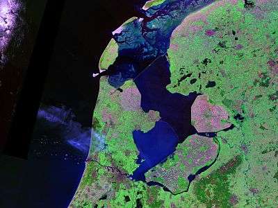 Landsat photo | |
 IJsselmeer in dark blue | |
| Location | Netherlands |
| Coordinates | 52°49′N 5°15′E / 52.817°N 5.250°ECoordinates: 52°49′N 5°15′E / 52.817°N 5.250°E |
| Primary inflows | IJssel, Overijsselse Vecht |
| Primary outflows | Wadden Sea (which empties to theNorth Sea) |
| Surface area | 1,100 km2 (420 sq mi) |
| Average depth | 5.5 m (18 ft) |
| Max. depth | 7 m (23 ft) |
| Surface elevation | −0.4 m (−1.3 ft) (winter) −0.2 m (−0.66 ft) (summer) |
| Designated | 29 August 2000 |
| Reference no. | 1246[1] |
The IJsselmeer (Dutch pronunciation: [ɛi̯səlˈmeːr]; West Frisian: Iselmar) is a closed off inland bay in the central Netherlands bordering the provinces of Flevoland, North Holland and Friesland. It measures 1100 km² with an average depth of 5.5 m. The river IJssel flows into the IJsselmeer.
The first two letters of the name are capitalized because IJ is a digraph or even a ligature in Dutch, so it is treated as a single letter.
History

Two thousand years ago Pomponius Mela, a Roman geographer, mentioned a complex of lakes at the current location of the IJsselmeer. He called it Lacus Flevo.[2] Over the centuries, the lake banks crumbled away due to flooding and wave action and the lake grew considerably. During the 12th and 13th centuries, storm surges and rising sea levels flooded large areas of land between the lake and the North Sea, turning the lake into a bay of the North Sea, called the Zuiderzee. The Zuiderzee continued to be a threat to the Dutch, especially when northwesterly storms funnel North Sea waters towards the English Channel, creating very high tides along the Dutch coast. During the 17th century, Zuiderzee dikes collapsed several times and plans were drawn up to eliminate the threat by draining the bay. Later drainage plans focused on creating fertile farmland. But it never got beyond the planning stage. It was only after the flood of 1916 that the legislature approved the Zuiderzee Works, a major hydraulic engineering project that involved building dikes, draining parts of the Zuiderzee and constructing the Afsluitdijk to keep tides and high water out.
In 1932 the Zuiderzee was closed off by the Afsluitdijk, a 32 km (20 mi) dike connecting Friesland and Noord-Holland on either side of the Zuiderzee. The Zuiderzee was no longer a sea inlet and was renamed IJsselmeer (Lake IJssel). The continued flow of riverwater flushed out the saltwater.
From 1929 till 1967, over half the IJsselmeer was drained, creating 1,979 km2 (764 sq mi) of polders[3]: Wieringermeerpolder, Noordoostpolder, East and South Flevoland.
In 1975, a dike was built between Enkhuizen and Lelystad as northern boundary of the Markerwaard, a planned but never realized polder in the IJsselmeer. This dike, the Houtribdijk or Markerwaarddijk, split the IJsselmeer in two parts. The former southern part of the IJsselmeer is now the hydrologically separate Markermeer.
In 1986 three polders in the IJsselmeer constituted the province of Flevoland, the twelfth province of the Netherlands.
Current use
Due to considerable amounts of water from the Rhine flowing through its distributary IJssel into the IJsselmeer, the closed off bay functions as a large freshwater reservoir, serving as a source for agriculture and drinking water. Outlet sluices in the Afsluitdijk regulate the water level of the IJsselmeer.
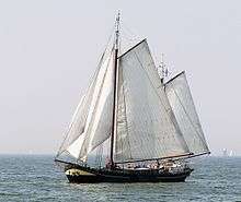
The IJsselmeer is used for transport and fishing. It also offers a number of opportunities for recreational activity, both on the water and on its shores. Due to the shallowness of the IJsselmeer, the Markermeer and the bordering lakes, its cities and fishing villages remained mostly unspoilt and have many historical buildings.[4]
To note also, the IJsselmeer is home to the offshore segments of Windpark Noordoostpolder. In the future, Windpark Fryslan [5] will also be built in this bay.
See also
References
- ↑ "IJsselmeer". Ramsar Sites Information Service. Retrieved 25 April 2018.
- ↑ Ley, Willy (October 1961). "The Home-Made Land". For Your Information. Galaxy Science Fiction. pp. 92–106.
- ↑ USGS Earthshots: IJsselmeer
- ↑ Authentic villages around IJsselmeer
- ↑ https://www.4coffshore.com/windfarms/windpark-fryslân-netherlands-nl0g.html
| Wikimedia Commons has media related to IJsselmeer. |