Maasdriel
| Maasdriel | |||
|---|---|---|---|
| Municipality | |||
.JPG) Church in Alem | |||
| |||
.svg.png) Location in Gelderland | |||
| Coordinates: 51°46′N 5°20′E / 51.767°N 5.333°ECoordinates: 51°46′N 5°20′E / 51.767°N 5.333°E | |||
| Country | Netherlands | ||
| Province | Gelderland | ||
| Government[1] | |||
| • Body | Municipal council | ||
| • Mayor | Henny van Kooten (SGP) | ||
| Area[2] | |||
| • Total | 75.46 km2 (29.14 sq mi) | ||
| • Land | 66.02 km2 (25.49 sq mi) | ||
| • Water | 9.44 km2 (3.64 sq mi) | ||
| Elevation[3] | 4 m (13 ft) | ||
| Population (August 2017)[4] | |||
| • Total | 24,316 | ||
| • Density | 368/km2 (950/sq mi) | ||
| Time zone | UTC+1 (CET) | ||
| • Summer (DST) | UTC+2 (CEST) | ||
| Postcode | 5320–5335, 6624 | ||
| Area code | 0418, 0487, 073 | ||
| Website |
www | ||

Maasdriel (![]()
Maasdriel was formed on 1 January, 1999 by the merger of the former municipalities of Ammerzoden (including Well, Wellseind en Wordragen), Hedel, Heerewaarden, Maasdriel (Alem, Hoenzadriel, Kerkdriel and Velddriel) and Rossum (including Hurwenen). The former municipality of Maasdriel was called "Driel" before 1944.[5]
Populated places
- Alem
- Ammerzoden
- Californië
- Hedel
- Heerewaarden
- Hoenzadriel
- Hurwenen
- Kerkdriel
- Rossum
- Velddriel
- Well
- Wellseind
- Wordragen
Topography

Dutch Topographic map of the municipality of Maasdriel, June 2015
Pictures
| Wikimedia Commons has media related to Maasdriel. |
 "Castle" Rossum
 Teisterbant in Kerkdriel
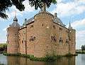 Ammersoyen Castle in Ammerzoden
 The castle of Well
%2C_2010-06-27_14.00%2C_Villa_Ouderzorg.jpg) Villa Ouderzorg in Hurwenen
Villa Ouderzorg in Hurwenen The windmill Sarah Catharina in Kerkdriel
- Hubertus-church in Alem
References
- ↑ "Burgemeester drs. G.E.W. Prick" (in Dutch). Gemeente Maasdriel. Retrieved 9 July 2014.
- ↑ "Kerncijfers wijken en buurten" [Key figures for neighbourhoods]. CBS Statline (in Dutch). CBS. 2 July 2013. Retrieved 12 March 2014.
- ↑ "Postcodetool for 5331CB". Actueel Hoogtebestand Nederland (in Dutch). Het Waterschapshuis. Archived from the original on 21 September 2013. Retrieved 9 July 2014.
- ↑ "Bevolkingsontwikkeling; regio per maand" [Population growth; regions per month]. CBS Statline (in Dutch). CBS. 27 October 2017. Retrieved 27 October 2017.
- ↑ Ad van der Meer and Onno Boonstra, "Repertorium van Nederlandse gemeenten", KNAW, 2006. "Archived copy". Archived from the original on 2007-02-20. Retrieved 2009-12-03.
External links

- Official website
Places adjacent to Maasdriel | ||||||||||
|---|---|---|---|---|---|---|---|---|---|---|
| ||||||||||

This article is issued from
Wikipedia.
The text is licensed under Creative Commons - Attribution - Sharealike.
Additional terms may apply for the media files.