Grahamstown, New South Wales
| Grahamstown New South Wales | |
|---|---|
 Grahamstown | |
|
Grahamstown | |
| Coordinates | 35°16′S 148°02′E / 35.267°S 148.033°ECoordinates: 35°16′S 148°02′E / 35.267°S 148.033°E |
| Population | 61 (2016 census)[1] |
| Postcode(s) | 2729 |
| Elevation | 309 m (1,014 ft) |
| Location | |
| LGA(s) | Snowy Valleys Council |
| County | Wynyard |
| State electorate(s) | Wagga Wagga |
| Federal Division(s) | Eden-Monaro |
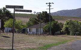
Grahamstown is a village community in the central east part of the Riverina and situated about 12 kilometres north from Adelong and 13 kilometres south from Tumblong. At the 2016 census, Grahamstown had a population of 61 people.[1]
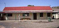
Grahamstown - Billy Goat Hall
Grahamstown consists of a small number of private residences on the Adelong to Tumblong road and the somewhat dilapidated Billy Goat Hall.
Grahamstown Post Office opened on 16 December 1881 and closed in 1981.[2]
See also
References
- 1 2 Australian Bureau of Statistics (27 June 2017). "Grahamstown (State Suburb)". 2016 Census QuickStats. Retrieved 29 June 2017.

- ↑ Premier Postal History, Post Office List, retrieved 2009-06-11
External links
![]()
This article is issued from
Wikipedia.
The text is licensed under Creative Commons - Attribution - Sharealike.
Additional terms may apply for the media files.