Parish of Indi
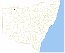
Location of the Parish
Indi, New South Wales, located at 29°48'45.0"S 143°24'00.0"E is a Parish of Ularara County in north west New South Wales.[1] It is between Milparinka, New South Wales and Wilcannia.[2]
Indi is located between Milparinka and Wanaaring. The main economic activity of the parish is agriculture, with the Ardoo and the Salisbury Downs Station .[3]
The climate is semi-arid, featuring low rainfall, very hot summer temperatures and cool nights in winter. The parish has a Köppen climate classification of BWh (Hot desert)[4].
The Parish is on traditional lands of the Karenggapa people.
References
- ↑ "Ularara". Geographical Names Register (GNR) of NSW. Geographical Names Board of New South Wales. Retrieved 11 August 2013.
- ↑ / Map of the County of Ularara, Western Division, Land Districts of Bourke (New South Wales. Department of Lands).
- ↑ / Map of the County of Ularara, Western Division, Land Districts of Bourke (New South Wales. Department of Lands).
- ↑ Peel, M. C.; Finlayson, B. L.; McMahon, T. A. (2007). "Updated world map of the Köppen–Geiger climate classification". Hydrol. Earth Syst. Sci. 11: 1633–1644. doi:10.5194/hess-11-1633-2007. ISSN 1027-5606. (direct: Final Revised Paper)
This article is issued from
Wikipedia.
The text is licensed under Creative Commons - Attribution - Sharealike.
Additional terms may apply for the media files.