Glenside, Pennsylvania
| Glenside | |
| Census-designated place Neighborhood of Cheltenham Township | |
 From top left: Grey Towers Castle, Glenside Welcome Sign at Limekiln Pike & Easton Road, Downtown Glenside, Glenside Trust Company Building, Philadelphia Skyline, former Glenside National Bank building, Glenside Memorial Hall | |
| Nickname: G Side | |
| Country | United States |
|---|---|
| State | Pennsylvania |
| County | Montgomery |
| Townships | Abington, Cheltenham |
| Elevation | 262 ft (79.9 m) |
| Coordinates | 40°06′11″N 75°09′08″W / 40.10306°N 75.15222°WCoordinates: 40°06′11″N 75°09′08″W / 40.10306°N 75.15222°W |
| Area | 1.3 sq mi (3.4 km2) |
| - land | 1.3 sq mi (3 km2) |
| - water | 0.0 sq mi (0 km2), 0% |
| Population | 8,384 (2010) |
| Density | 6,449.2/sq mi (2,490.1/km2) |
| Timezone | Eastern Standard Time (UTC-5) |
| - summer (DST) | Eastern Daylight Time (UTC-4) |
| ZIP Code | 19038 |
| Area code | 215 and 267 |
| Commissioners | J. Andrew Sharkey Kathy A. Hampton (East) |
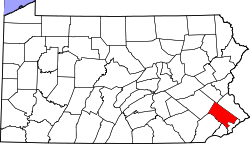
 Location of Glenside in Pennsylvania  Glenside, Pennsylvania (the US) | |
Glenside is a census-designated place (CDP) bordering Northwest Philadelphia in Abington, and Cheltenham townships, Montgomery County, Pennsylvania, United States. The population was 8,384 at the 2010 census on a land area of only 1.3 square miles. The Glenside station is one of the busiest in the SEPTA system. Glenside is located about 6 miles from Center City Philadelphia.
Glenside is bordered to the South by Wyncote, the East by Jenkintown, West by Laverock and Cheltenham twp section of North Hills, and to the North by the Abington twp neighborhoods of North Hills, Ardsley, Roslyn, and Abington.
Geography
.jpg)
Glenside is located at 40°6′11″N 75°9′8″W / 40.10306°N 75.15222°W (40.102960, −75.152264).[1]
According to the United States Census Bureau, the CDP has a total area of 1.3 square miles (3.4 km2), all of it land.
Glenside is split into two townships: Abington Township, and Cheltenham Township, with the latter being where the majority of Glenside is located, including the United States Post Office, Glenside Library, and Glenside Memorial Hall.
Topography
The altitude ranges from 232 feet near Glenside Memorial Hall to 405 feet on Sunset and Lindley Roads. The majority of Glenside is around 300 feet in elevation; it is 238 feet at the intersection of Waverly and Easton roads, the center of Glenside.
Demographics

| Historical population | |||
|---|---|---|---|
| Census | Pop. | %± | |
| 1990 | 8,704 | — | |
| 2000 | 7,914 | −9.1% | |
| 2010 | 8,384 | 5.9% | |
As of the 2010 census, the CDP was 85.4% White, 7.2% Black or African American, 0.2% Native American, 2.8% Asian, 1.0% were Some Other Race, and 1.7% were two or more races. 2.9% of the population were of Hispanic or Latino ancestry.[2]
As of the census[3] of 2000, there were 7,914 people, 3,103 households, and 2,013 families residing in the CDP. The population density was 6,217.4 people per square mile (2,406.0/km2). There were 3,181 housing units at an average density of 2,499.1/sq mi (967.1/km2). The racial makeup of the CDP was 88.97% White, 6.66% African American, 0.10% Native American, 3.02% Asian, 0.03% Pacific Islander, 0.27% from other races, and 0.96% from two or more races. Hispanic or Latino of any race were 1.44% of the population.
There were 3,103 households, out of which 31.3% had children under the age of 18 living with them, 52.7% were married couples living together, 9.2% had a female householder with no husband present, and 35.1% were non-families. 28.8% of all households were made up of individuals, and 9.7% had someone living alone who was 65 years of age or older. The average household size was 2.54 and the average family size was 3.21.
In the CDP, the population was spread out, with 25.0% under the age of 18, 8.0% from 18 to 24, 30.8% from 25 to 44, 22.3% from 45 to 64, and 13.8% who were 65 years of age or older. The median age was 36 years. For every 100 females, there were 91.3 males. For every 100 females age 18 and over, there were 87.3 males.
The median income for a household in the CDP was $58,868, and the median income for a family was $74,025. Males had a median income of $48,378 versus $35,629 for females. The per capita income for the CDP was $26,393. About 1.6% of families and 3.4% of the population were below the poverty line, including 2.4% of those under age 18 and 3.6% of those age 65 or over.
Transportation


Glenside is located at about a 30-minute drive to downtown Philadelphia, 2 hours to New York City, 2 hours to the Pocono Mountains, and 1.5 hours to the Jersey shore. Glenside has easy access to many major US highways, such as US Route 1, Interstate 95, Interstate 76, the Pennsylvania Turnpike, and US Route 30.
SEPTA
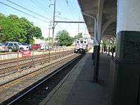
Glenside is served by SEPTA regional rail at the Glenside Train Station. The station, which was originally called Abington, has its roots back with the North Pennsylvania Railroad and the Reading Railroad. Trains north split at Carmel Interlocking, just north of the station, and either go to Lansdale/Doylestown Line or the Warminster Line. Trains going south go to Philadelphia, which is about a 25-minute ride to Jefferson Station and 35 minutes to 30th Street Station. Express trains make it to Jefferson in as little as 20 minutes. With two lines serving the station, the frequent train service makes Glenside an attractive place to live. Glenside is also served by SEPTA buses, in particular, routes 77 and 22.
Amtrak
Glenside is accessible to Amtrak, which provides train service to most major cities in the Northeast. Glenside is a 30-minute SEPTA ride or 30-minute drive to Amtrak's 30th Street Station, the 3rd busiest station in the Amtrak system, in Center City Philadelphia.
Roads
Glenside also has several major local roads, such as:
![]()
![]()
![]()
Glenside is located in close proximity to several national roads:
- Glenside to
- Glenside to


- Glenside to


- Glenside to

- Glenside to

Climate
Glenside has a typical Northeast climate. Summers are hot, with highs averaging 84–89 °F (29–32 °C). The middle of summer sees several days breaking 90 °F (32 °C), with only one or two days rising above 100 °F (38 °C). Summer nights can be erratic, ranging from 67 to 72 °F (19 to 22 °C). Spring and Fall are pleasant, with the highs usually hovering around 60 °F (16 °C), and lows of 47–49 °F (8–9 °C). Winters are cold, with highs averaging 33 to 37 °F (1 to 3 °C) and lows of 17 to 19 °F (−8 to −7 °C). Numerous days in the winter remain below the freezing mark, with lows of 13 to 17 °F (−11 to −8 °C). In addition, several days in late December and early January, high temperatures are 13 to 19 °F (−11 to −7 °C) and lows can plummet to 1 to 9 °F (−17 to −13 °C). The following is a chart of the average temperatures in Glenside.[4]
| Climate data for Glenside, Pennsylvania | |||||||||||||
|---|---|---|---|---|---|---|---|---|---|---|---|---|---|
| Month | Jan | Feb | Mar | Apr | May | Jun | Jul | Aug | Sep | Oct | Nov | Dec | Year |
| Record high °F | 73 | 73 | 88 | 95 | 96 | 102 | 102 | 102 | 98 | 88 | 82 | 76 | 102 |
| Average high °F | 37 | 42 | 50 | 62 | 72 | 81 | 85 | 84 | 77 | 65 | 54 | 43 | 62.6 |
| Average low °F | 19 | 24 | 32 | 41 | 51 | 62 | 67 | 65 | 56 | 43 | 34 | 26 | 43 |
| Record low °F | −11 | −3 | −1 | 16 | 32 | 34 | 45 | 37 | 30 | 20 | 11 | −10 | −11 |
| Average precipitation inches | 3.44 | 3.01 | 4.32 | 4.12 | 4.37 | 4.6 | 5.05 | 3.98 | 4.53 | 3.82 | 3.94 | 4.23 | 49.4 |
| Record high °C | 23 | 23 | 31 | 35 | 36 | 39 | 39 | 39 | 37 | 31 | 28 | 24 | 39 |
| Average high °C | 3 | 6 | 10 | 17 | 22 | 27 | 29 | 29 | 25 | 18 | 12 | 6 | 17 |
| Average low °C | −7 | −4 | 0 | 5 | 11 | 17 | 19 | 18 | 13 | 6 | 1 | −3 | 6 |
| Record low °C | −24 | −19 | −18 | −9 | 0 | 1 | 7 | 3 | −1 | −7 | −12 | −23 | −24 |
| Average precipitation mm | 87.4 | 76.5 | 109.7 | 104.6 | 111 | 117 | 128.3 | 101.1 | 115.1 | 97 | 100.1 | 107.4 | 1,255 |
| Source: The Weather Channel "Average Weather for Glenside, PA". The Weather Channel. Retrieved September 30, 2011. | |||||||||||||
Locale
Places adjacent to Glenside, Pennsylvania | ||||||||||
|---|---|---|---|---|---|---|---|---|---|---|
| ||||||||||
Education

Public Education
Since Glenside is located in Cheltenham, and Abington Townships, not all Glenside residents go to schools within the same district. A Glenside resident will follow one of these paths, depending on which township they live in.
- Cheltenham Township
- Glenside Elementary (K–4)
- Elkins Park Middle School (5–6)
- Cedarbrook Middle School (7–8)
- Cheltenham High School (9–12)
- Abington Township
- Copper Beech Elementary School (K–6)
- Abington Junior High School (7–9)
- Abington Senior High School (10–12)
Universities
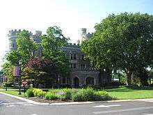
Glenside is home to Arcadia University, a private co-educational four-year liberal arts university. Arcadia is well known for its Study Abroad programs, which two-thirds of their students participate in. The University offers majors in the College of Arts and Sciences, College of Health Sciences, School of Education, and School of Global Business. The campus is set on National Historic Landmark Grey Towers Castle, which was built in 1893.
Other institutions
Glenside is also home to Westminster Theological Seminary, a Presbyterian and Reformed Christian graduate institution. There is a satellite campus in London. Catholic education in Glenside is supported by Saint Joseph the Protector School on Fairhill Ave. Students from this school often attend the local Catholic high school, Bishop McDevitt.
Points of interest
- Harry Renninger Park – formerly known as Glenside Park, was once home to minor league baseball play. Historical photos show large grandstands decorated with bunting for seating crowds.
- Grove Park

- Penbryn Park
- Glenside Pool – Relocated and Constructed in 1967[5]
- Glenside Free Library – Established 1928, member MCLINC (Montgomery County Library & Information Network Consortium)
- Edge Hill Woods Wildlife Sanctuary
- Keswick Theatre - Built in 1928, the theatre hosts a variety of world-class entertainers and shows. It was added to the National Register of Historic Places in 1983.
- Keswick Village - Historic Keswick Village thrives as a cultural hub and center of commerce. Charming, Tudor-style, pedestrian-friendly Village is home to many unique offerings.
- Downtown - Many thriving local businesses and restaurants line Easton Road and down the side streets.
Landmarks
- Keswick Theatre – A small theatre in the Glenside's Keswick Village, was placed on the National Register of Historic Places in 1983.
- The town is home to Arcadia University, a 71-acre (290,000 m2) campus that features the National Historic Landmark Grey Towers Castle.
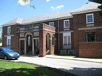
- Glenside Memorial Hall – A hall dedicated to World War I veterans, it can accommodate up to 180 people for banquets, parties, etc. It was listed on the National Register of Historic Places in 2004.
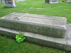
- Holy Sepulchre Cemetery – Large cemetery with several notable burials, including Connie Mack, Frank Rizzo and Michael Crescenz.
Media
Glenside is served by two newspapers: Times Chronicle and Glenside News, both papers a division of Montgomery News.[6]
The following is a list of radio stations that can be heard in the Glenside area.[7]
- FM
- 88.5 WXPN (Adult Album Alternative)
- 90.1 WRTI (Classical/Jazz)
- 92.5 WXTU (Country)
- 93.3 WMMR (Active rock)
- 94.1 WIP (Sports Talk)
- 95.7 WBEN (Adult Hits)
- 96.5 WTDY-FM (Contemporary hit radio/Pop)
- 98.1 WOGL (Oldies/Classic Hits)
- 98.9 WUSL (Mainstream Urban)
- 100.3 WRNB (Adult Urban Contemporary)
- 101.1 WBEB (Soft rock)
- 102.1 WIOQ (Contemporary hit radio/Pop)
- 102.9 WMGK (Classic rock)
- 103.9 WPPZ (Urban Gospel)
- 104.5 WRFF (Modern Rock)
- 105.3 WDAS (Urban Adult Contemporary)
- 106.1 WISX (Hot AC)
- 106.9 WKVP (Contemporary Christian)
Independence Day Parade
The annual Independence Day parade held in Glenside every July 4 is reported to be the largest such parade in the greater Philadelphia area. The parade began in 1904 and is now sponsored by the Greater Glenside Patriotic Association. It is a very traditional parade, including all the area volunteer fire companies, a variety of bands and other musical performers, church groups and community organizations, and local and state elected officials (Former-Governor Ed Rendell has been a frequent participant). One unique and much-anticipated show is the Schuylkill County Motorcycle Drill Team. It is one of the nation's longest consecutive Fourth of July parades.
Notable residents
- Johnny Callison - professional baseball player for Philadelphia Phillies and Chicago Cubs
- George Castle – son of J.R. Castle, lacrosse player for Philadelphia Wings
- J.R. Castle – former lacrosse player
- Clay Dalrymple - professional baseball player for Philadelphia Phillies and Baltimore Orioles
- Tony Donatelli – soccer player for Charleston Battery
- Bill Hyndman – amateur golfer
- Milt Jacobson – minor league baseball player for Washington Senators[8]
- Bob Perkins - radio host at WRTI
- Jesse Purnell – professional baseball player for Philadelphia Phillies
- Russell Swan – Survivor contestant
- Richard Ward – actor
- George Wilson – College Football Hall of Fame football player
- Ray Ellis – artist[9]
References
- ↑ "US Gazetteer files: 2010, 2000, and 1990". United States Census Bureau. 2011-02-12. Retrieved 2011-04-23.
- ↑ Census 2010: Pennsylvania. Usatoday.Com. Retrieved on 2013-07-21.
- ↑ "American FactFinder". United States Census Bureau. Archived from the original on 2013-09-11. Retrieved 2008-01-31.
- ↑ "Average Weather for Glenside, PA - Temperature and Precipitation". Weather.com. Retrieved 2011-10-24.
- ↑ "Community Pools - Cheltenham, PA". cheltenhamtownship.org.
- ↑ "Montgomery News". Montgomery News. Retrieved 2011-10-24.
- ↑ "Glenside, Pennsylvania (PA 19038) profile: population, maps, real estate, averages, homes, statistics, relocation, travel, jobs, hospitals, schools, crime, moving, houses, news". City-data.com. Retrieved 2011-10-24.
- ↑ "Glenside antiques, collectibles merchant talks a great game". Montgomery Media.
- ↑ Wolfson, C. K. "A Picture of Success". Martha's Vineyard Magazine. Retrieved 18 August 2015.
External links
| Wikimedia Commons has media related to Glenside, Pennsylvania. |
- Downtown Glenside from Google Street View
- Greater Glenside Chamber of Commerce
- Greater Glenside Patriotic Association
- Cheltenham Township Home Page
- Abington Township Home Page
Founded 1682 | ||
| Communities | 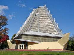 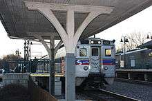   | |
| Education |
| |
| National Historic Sites | ||
| People | ||
| See also | ||
| Historical railroads | ||
| Regional rail lines | ||
| Regional rail stations | ||
| SEPTA bus routes | ||
| Infrastructure | ||
| Counties |  | |
|---|---|---|
| Major cities | ||
| Cities and towns 50k-99k | ||
| Cities and towns 30k-50k | ||