Green Lane, Pennsylvania
| Borough of Green Lane | |
|---|---|
| Borough | |
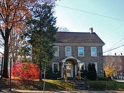 William and Caroline Schall House on Main Street | |
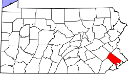
 Location of Green Lane in Montgomery County, Pennsylvania. | |
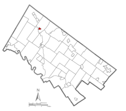
 Green Lane Location of Green Lane in Pennsylvania  Green Lane Green Lane (the US) | |
| Coordinates: 40°20′14″N 75°28′09″W / 40.33722°N 75.46917°WCoordinates: 40°20′14″N 75°28′09″W / 40.33722°N 75.46917°W | |
| Country | United States |
| State | Pennsylvania |
| County | Montgomery |
| Incorporated | December 10, 1875 |
| Government | |
| • Type | Council-manager |
| • Mayor | Lynn Wolfe |
| Area[1] | |
| • Total | 0.34 sq mi (0.88 km2) |
| • Land | 0.33 sq mi (0.86 km2) |
| • Water | 0.01 sq mi (0.02 km2) |
| Elevation | 239 ft (73 m) |
| Population (2010) | |
| • Total | 508 |
| • Estimate (2016)[2] | 498 |
| • Density | 1,504.53/sq mi (581.25/km2) |
| Time zone | UTC-5 (EST) |
| • Summer (DST) | UTC-4 (EDT) |
| ZIP code | 18054 |
| Area code(s) | 215 & 267 |
| FIPS code | 42-31088 |
Green Lane is a borough in Montgomery County, Pennsylvania, United States. The population was 508 at the 2010 census.
It is part of the Upper Perkiomen School District and Boyertown Area School District.
History
The William and Caroline Schall House was added to the National Register of Historic Places in 2007.[3]
Geography
Green Lane is located at 40°20′14″N 75°28′9″W / 40.33722°N 75.46917°W (40.337224, -75.469300).[4]
According to the United States Census Bureau, the borough has a total area of 0.3 square miles (0.78 km2), all of it land.
Demographics
| Historical population | |||
|---|---|---|---|
| Census | Pop. | %± | |
| 1880 | 187 | — | |
| 1890 | 237 | 26.7% | |
| 1900 | 272 | 14.8% | |
| 1910 | 372 | 36.8% | |
| 1920 | 332 | −10.8% | |
| 1930 | 388 | 16.9% | |
| 1940 | 478 | 23.2% | |
| 1950 | 550 | 15.1% | |
| 1960 | 582 | 5.8% | |
| 1970 | 543 | −6.7% | |
| 1980 | 542 | −0.2% | |
| 1990 | 442 | −18.5% | |
| 2000 | 584 | 32.1% | |
| 2010 | 508 | −13.0% | |
| Est. 2016 | 498 | [2] | −2.0% |
| Sources:[5][6][7] | |||
As of the 2010 census, the borough was 97.4% White, 2.0% Black or African American, 0.4% Native American, and 0.2% Asian. 1.0% of the population were of Hispanic or Latino ancestry.[8]
As of the census[6] of 2000, there were 584 people, 231 households, and 164 families residing in the borough. The population density was 1,797.3 people per square mile (704.6/km2). There were 235 housing units at an average density of 723.2 per square mile (283.5/km2). The racial makeup of the borough was 97.43% White, 1.03% African American, 0.17% Native American, and 1.37% from two or more races. Hispanic or Latino of any race were 1.03% of the population.
There were 231 households, out of which 32.0% had children under the age of 18 living with them, 55.0% were married couples living together, 9.1% had a female householder with no husband present, and 28.6% were non-families. 23.8% of all households were made up of individuals, and 9.5% had someone living alone who was 65 years of age or older. The average household size was 2.53 and the average family size was 2.97.
In the borough the population was spread out, with 24.8% under the age of 18, 9.1% from 18 to 24, 32.7% from 25 to 44, 20.7% from 45 to 64, and 12.7% who were 65 years of age or older. The median age was 36 years. For every 100 females there were 103.5 males. For every 100 females age 18 and over, there were 106.1 males.
The median income for a household in the borough was $49,167, and the median income for a family was $55,714. Males had a median income of $40,000 versus $30,500 for females. The per capita income for the borough was $21,123. About 4.9% of families and 7.4% of the population were below the poverty line, including 10.9% of those under age 18 and 8.9% of those age 69 or over.
Politics and government
Green Lane has a borough secretary, a mayor and borough council.
The borough is part of the Eight Congressional District (represented by Rep. Brian Fitzpatrick), Pennsylvania's 147th Representative District (represented by Marcy Toepel) and the 24th State Senate District (represented by Sen. Bob Mensch). Green Lane's current Mayor is Lynn Wolfe.
| Year | Republican | Democratic |
|---|---|---|
| 2016 | 54.8% 137 | 40.0% 100 |
| 2012 | 48.7% 108 | 50.9% 113 |
| 2008 | 47.9% 115 | 50.0% 120 |
| 2004 | 60.1% 128 | 39.4% 84 |
| 2000 | 55.3% 146 | 40.9% 108 |
Recreation
The eponymous Green Lane Park in northwestern Montgomery County offers 3,400 acres (14 km2). The park contains 25 miles (40 km) of paved and dirt trails that are used year-round by equestrians, walkers, and bikers. In addition to the trails, visitors may fish, boat, or take an educational lesson at the nature center.[10]
References
- ↑ "2016 U.S. Gazetteer Files". United States Census Bureau. Retrieved Aug 14, 2017.
- 1 2 "Population and Housing Unit Estimates". Retrieved June 9, 2017.
- ↑ National Park Service (2010-07-09). "National Register Information System". National Register of Historic Places. National Park Service.
- ↑ "US Gazetteer files: 2010, 2000, and 1990". United States Census Bureau. 2011-02-12. Retrieved 2011-04-23.
- ↑ "Census of Population and Housing". U.S. Census Bureau. Archived from the original on 12 May 2015. Retrieved 11 December 2013.
- 1 2 "American FactFinder". United States Census Bureau. Archived from the original on 2013-09-11. Retrieved 2008-01-31.
- ↑ "Incorporated Places and Minor Civil Divisions Datasets: Subcounty Resident Population Estimates: April 1, 2010 to July 1, 2012". Population Estimates. U.S. Census Bureau. Archived from the original on 17 June 2013. Retrieved 11 December 2013.
- ↑ "Census 2010: Pennsylvania". USA Today. Retrieved 2014-07-09.
- ↑ "Montgomery County Election Results". Montgomery County, Pennsylvania. Retrieved January 16, 2017.
- ↑ "Green Lane Park". Montgomery County, Pennsylvania. 2014-06-14. Retrieved 2014-07-09.