Zieglerville, Pennsylvania
| Zieglerville, Pennsylvania | |
|---|---|
| Unincorporated community | |
 Zieglerville  Zieglerville | |
| Coordinates: 40°16′37″N 75°28′48″W / 40.27694°N 75.48000°WCoordinates: 40°16′37″N 75°28′48″W / 40.27694°N 75.48000°W | |
| Country | United States |
| State | Pennsylvania |
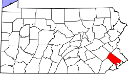
| County | Montgomery |
| Township | Lower Frederick |
| Elevation | 226 ft (69 m) |
| Time zone | UTC-5 (Eastern (EST)) |
| • Summer (DST) | UTC-4 (EDT) |
| ZIP code | 19492 |
| Area code(s) | 610 and 484 |
| GNIS feature ID | 1988991[1] |
Zieglerville is an unincorporated community in Lower Frederick Township, Montgomery County, Pennsylvania, United States.[2] Its ZIP Code is 19492[3] and it is located on the west side of the Perkiomen Creek where Route 29 and Route 73 split at a roundabout just north of Schwenksville.
The Bridge in Upper Frederick Township (Zieglerville, Pennsylvania) was listed on the National Register of Historic Places in 1988.[4]
Geography
Zieglerville is located at 40°27′07″N 75°48′00″W / 40.45194°N 75.80000°W It is 220 feet above sea level.[5]
References
- ↑ "Zieglerville". Geographic Names Information System. United States Geological Survey.
- ↑ "Zieglerville, Pennsylvania". Geographic Names Information System. United States Geological Survey.
- ↑ United States Postal Service (2012). "USPS - Look Up a ZIP Code". Retrieved 2012-02-15.
- ↑ National Park Service (2010-07-09). "National Register Information System". National Register of Historic Places. National Park Service.
- ↑ Hometownlocator.com
Places adjacent to Zieglerville, Pennsylvania | ||||||||||
|---|---|---|---|---|---|---|---|---|---|---|
| ||||||||||
This article is issued from
Wikipedia.
The text is licensed under Creative Commons - Attribution - Sharealike.
Additional terms may apply for the media files.