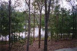
Enoggera Reservoir, Queensland
| Enoggera Reservoir Brisbane, Queensland | |||||||||||||||
|---|---|---|---|---|---|---|---|---|---|---|---|---|---|---|---|
 Enoggera Reservoir Dam | |||||||||||||||
| Population | 24 (2011 census)[1] | ||||||||||||||
| Postcode(s) | 4520 | ||||||||||||||
| Location | 8 km (5 mi) from Brisbane CBD | ||||||||||||||
| LGA(s) |
City of Brisbane (The Gap Ward) | ||||||||||||||
| State electorate(s) | Cooper | ||||||||||||||
| Federal Division(s) | Ryan | ||||||||||||||
| |||||||||||||||
Enoggera Reservoir is an outer suburb of City of Brisbane, Queensland, Australia, which is located 8 kilometres (5 mi) north-west of the CBD and bordering the Moreton Bay Region and The Gap.[2] It contains the neighbourhood of Peewee Bend.[3] In the 2011 census, Enoggera Reservoir had a population of 24 people.[1]
History
The Enoggera Reservoir suburb is named after the Enoggera Reservoir Dam. As of 12 February 2011, sufficient water inflows returned the reservoir to usable levels, and water is now used to supply neighbouring suburbs. Prior to this the reservoir levels were insufficient for water supply, primarily due to the drought which was experienced by South-East Queensland prior to the January 2011 floods.
Heritage listings
Enoggera Reservoir has a number of heritage-listed sites, including:
- 30 & 50 Mt Nebo Road: Enoggera Dam[4]
- 847 Mt Nebo Road: Slab Hut Farm[5]
References
- 1 2 Australian Bureau of Statistics (31 October 2012). "Enoggera Reservoir (SSC)". 2011 Census QuickStats. Retrieved 14 January 2015.

- ↑ "Enoggera Reservoir - suburb in the City of Brisbane (entry 50018)". Queensland Place Names. Queensland Government. Retrieved 28 September 2017.
- ↑ "Peewee Bend (entry 26299)". Queensland Place Names. Queensland Government. Retrieved 18 January 2015.
- ↑ "Enoggera Reservoir (entry 602458)". Queensland Heritage Register. Queensland Heritage Council. Retrieved 6 July 2013.
- ↑ "Slab Hut Farm (entry 600329)". Queensland Heritage Register. Queensland Heritage Council. Retrieved 6 July 2013.
External links
| Wikimedia Commons has media related to Enoggera Reservoir, Queensland. |
- "Enoggera/E. Reservoir". BRISbites. Brisbane City Council. Archived from the original on 19 July 2008.
- "Enoggera Reservoir". Our Brisbane. Brisbane City Council. Archived from the original on 19 January 2008.
Coordinates: 27°26′S 152°52′E / 27.433°S 152.867°E