Coorparoo, Queensland
| Coorparoo Brisbane, Queensland | |||||||||||||||
|---|---|---|---|---|---|---|---|---|---|---|---|---|---|---|---|
 Coorparoo Primary School | |||||||||||||||
 Coorparoo | |||||||||||||||
| Coordinates | 27°29′44″S 153°03′44″E / 27.49556°S 153.06222°ECoordinates: 27°29′44″S 153°03′44″E / 27.49556°S 153.06222°E | ||||||||||||||
| Population | 16,282 (2016 census)[1] | ||||||||||||||
| • Density | 3,072/km2 (7,960/sq mi) | ||||||||||||||
| Postcode(s) | 4151[2] | ||||||||||||||
| Area | 5.3 km2 (2.0 sq mi) | ||||||||||||||
| Location | 4 km (2 mi) SE of CBD[3] | ||||||||||||||
| LGA(s) |
City of Brisbane (Coorparoo Ward)[4] | ||||||||||||||
| State electorate(s) | Greenslopes | ||||||||||||||
| Federal Division(s) | Griffith | ||||||||||||||
| |||||||||||||||
Coorparoo is a suburb of Brisbane, Queensland, Australia, 4 kilometres (2.5 mi) south-east of the CBD.[3] It borders Camp Hill, Holland Park, Stones Corner, Greenslopes, East Brisbane and Norman Park.
Toponymy
Coorparoo was chosen as the name of the suburb at a public meeting on 22 March 1875, before which it was known as Four Mile Camp.[5][6] The name Coorparoo is likely derived from an Aboriginal name for Norman Creek, probably recorded by early surveyors as Koolpuroom.[7] The word is thought to refer to either a place associated with mosquitoes, or a sound made by the 'gentle dove'.[5] The latter explanation appears doubtful though, as 'gentle dove' may mean the spotted dove, which was introduced to the area in 1912, long after the name Coorparoo was adopted.[5]
History
Aboriginal history
The Coorparoo Clan lived south of the Brisbane River and generally camped along creeks. Their name comes from Kulpurum, which was the word for Norman Creek or a tributary of it. They continued to occupy watercourse campsites after white settlement, but other clans from the region began to move into South Brisbane.
In 1846, there were reports of Aborigines raiding produce along Norman Creek. In 1853, there was a fight between Ningy Ningy, Bribie Island, Amity Point, and Logan peoples at Norman Creek. A visitor in 1855 reported many camps and fishing spots between Stones Corner and the mouth of Norman Creek. In 1959 an eighty-year-old woman told of frequent corroborees on the banks of the creek in Norman Park. Corroborees were also held at a little creek that crossed Norfolk Street.[8]
Urban development
On 17 June 1856, ten farms were sold from the Parish of Bulimba near Stones Corner. Investors bought all but two of them. The next year James Warner surveyed land on the other side of the road for a second land auction.
Samuel Stevens donated two acres of his property near the junction of Cavendish and Old Cleveland Roads for use of a school. He declined the offer of naming the area "Steven's Town".
.jpg)
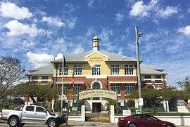
In 1876, the Coorparoo State School was opened and Frederick Robinson began offering public transport in a wagonette from Coorparoo Junction to Victoria Bridge. The 1880s land boom was a spur to profit from land. John Black was the first to subdivide land in the area in 1882 and later a variety of subdivisions were offered to the public. The construction of the bridge at Stanley Street (1886) and the development of the Stanley Bridge Estate made the area more attractive to purchasers. In 1887, the tramway was extended to Buranda, putting the western end of Coorparoo close to tram travel.
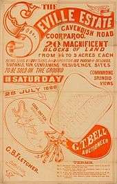
Coorparoo had been part of the Bulimba Divisional Board since 1879. However, in 1888, as a result of dissatisfaction with this situation, a petition was taken resulting in the creation of Shire of Coorparoo. A bridge was built at Burnetts Swamp (Stones Corner) and important road improvements took place. Development was taking off. In 1889 there were 2,500 people in the shire.
The floods of 1889 and 1893 hit the low-lying areas of Coorparoo. The flooding combined with the 1890s depression slowed development in the area. In 1900 there were actually fewer houses than there had been ten years earlier. The settlement was dense from Stones Corner to Kirkland Avenue (originally named Wecker Street but it was changed in 1914 in the wake of anti-German sentiment), but further out it was mainly bush with a few isolated farms and houses. The only major industry was the brickworks of Abraham James at St Leonards Street, which employed eighty men in the 1880s.
After World War I, land prices increased as property sales boomed. Coorparoo did not really begin to expand again until the tram service was extended to Stones Corner in 1902 and Coorparoo Junction in 1915. The number of houses increased from 613 in 1911 to 1,467 ten years later.
Demographics
The 2016 Census recorded 16,282 residents in Coorparoo, of whom 51.2% were female and 48.8% were male. The median age of the population was 34; 4 years younger than the Australian average.[9]
70.7% of people living in Coorparoo were born in Australia, with the next most common countries of birth being India (3.6%), New Zealand (3%), England (2.5%), Nepal (0.9%), and China (0.7%). 77.6% of people spoke English as their first language, while the other most common responses were Spanish (1.2%), Hindi (1.2%), Punjabi (1.1%), Mandarin (1%), and Greek (1%).[9]
Future Growth
In 2015, the old Myer Department store building on the corner of Old Cleveland Road and Cavendish Road was demolished. In its place are 3 residential towers with commercial development on the lower floors. The development, known as Coorparoo Square opened in 2017 and features a 10 screen Dendy cinema, Aldi Supermarket and speciality retailers and coffee shops. Under the development, will be a void for the future Eastern Busway station.[10]
Sports
Coorparoo is home of the Eastern Suburbs District Rugby League Football Club who play their home games at Langlands Park. Langlands Park regularly hosts training sessions for the Queensland and Australian Rugby League teams when they are playing in Brisbane.
The Brisbane Lions train during the week at Giffin Park, also in Coorparoo.
Education
State schools in Coorparoo include Coorparoo State School and Coorparoo Secondary College.[11] There are four Catholic schools: St James Primary School, Loreto College Coorparoo (girls, 7–12), Mt Carmel Primary school (co-ed, prep–6), and Villanova College (boys, 5–12).
Landmarks
Coorparoo has a range of distinctive homes, buildings, and sites of interest, including:
- Spanish Mission Revival homes along Cavendish Road. This was a popular inter-war house style introduced from California.
- Ridgelands (1880s), built for the Blundell family
- Cardington (1880s) at the corner of Norfolk Street and Cavendish Road. This residence was built by Thomas Howling who had purchased the allotments from early settler George Harden.
- Barston Place (1880) on Norfolk Street, built for Scottish born James Burstall and named after his birthplace.
- Coorparoo Shire Hall (1892) at the corner of Cavendish Road and Halstead Street. The building is now owned by the Coorparoo School of Arts and Memorial Hall Association Inc. and is known as The School of Arts Hall.
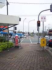
- Restored Tram Post at the corner of Old Cleveland and Cavendish Roads.
- Hatherton (1886). This elite residence was built for Reuben Nicklin whose previous residence was called Langlands. Reuben and his wife Jane were drowned in the RMS Quetta disaster in 1890. The house has subsequently been extensively renovated and changed and is now known as the heritage-listed "Queen Alexandra Home" having been used as a Methodist Home for children, teaching classrooms for the local TAFE College and more recently as a community centre.
- Chatsworth (1888), built for William Evans who worked at Stewarts of Stones Corner. Chatsworth Road is named after this residence.
- Langlands (1883), built for Reuben Nicklin. This building is in the grounds of the present Villanova College and is the oldest surviving masonry residence in Coorparoo.
- Cavendish Road
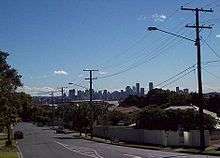
- Kirkland Avenue. An affluent tree lined street offering sweeping panoramic views of the Brisbane CBD. This avenue was lined with wonderful old substantial Queenslander houses until the late 1960s when the Brisbane City Council allowed their demolition for blocks of units. Some of these units have been demolished and replaced with more modern blocks of units.
Heritage listings
Coorparoo has a number of heritage-listed sites, including:
- Coorparoo Substation No. 210 (12 Main Avenue)[12]
- Coorparoo School of Arts and RSL Memorial Hall (208 Cavendish Road)[13]
- former Coorparoo Fire Station (219 Cavendish Road)[14]
- Coorparoo State School (327 Old Cleveland Road)[15]
- Queen Alexandra Home (347 Old Cleveland Road)[16]
References
- ↑ Australian Bureau of Statistics (27 June 2017). "Coorparoo (State Suburb)". 2016 Census QuickStats. Retrieved 13 April 2018.

- ↑ "Find a postcode". Australia Post. Retrieved 19 January 2014.
- 1 2 Centre for the Government of Queensland. "Coorparoo and Coorparoo Shire". Retrieved 19 January 2014.
- ↑ "Coorparoo Ward". Brisbane City Council. Brisbane City Council. Retrieved 12 March 2017.
- 1 2 3 "Coorparoo (entry 47603)". Queensland Place Names. Queensland Government. Retrieved 19 January 2014.
- ↑ "Local History – Coorparoo". Australian Broadcasting Corporation. Retrieved 31 January 2014.
- ↑ "From the News of 60 Years Ago". The Queenslander. Brisbane, Qld.: National Library of Australia. 27 February 1936. p. 51. Retrieved 13 September 2011.
- ↑ "Coorparoo". RE/MAX. Retrieved 31 January 2014.
- 1 2 Australian Bureau of Statistics (31 October 2012). "Coorparoo, Qld (State Suburb)". 2011 Census QuickStats. Retrieved 24 October 2013.
- ↑ "Coorparoo to become a cultural hub". bmag. Retrieved 2015-12-06.
- ↑ "Welcome". Coorparoo Secondary College. Retrieved 2016-03-21.
- ↑ "Coorparoo Substation No. 210 (entry 602495)". Queensland Heritage Register. Queensland Heritage Council. Retrieved 6 July 2013.
- ↑ "Coorparoo School of Arts and RSL Memorial Hall (entry 602054)". Queensland Heritage Register. Queensland Heritage Council. Retrieved 6 July 2013.
- ↑ "Coorparoo Fire Station (former) (entry 600569)". Queensland Heritage Register. Queensland Heritage Council. Retrieved 6 July 2013.
- ↑ "Coorparoo State School (entry 650047)". Queensland Heritage Register. Queensland Heritage Council. Retrieved 24 August 2017.
- ↑ "Queen Alexandra Home (entry 600185)". Queensland Heritage Register. Queensland Heritage Council. Retrieved 6 July 2013.
External links
| Wikimedia Commons has media related to Coorparoo, Queensland. |
- University of Queensland: Queensland Places: Coorparoo and Coorparoo Shire
- Coorparoo Uniting Church history – founded 1886
- "Coorparoo". BRISbites. Brisbane City Council. Archived from the original on 20 July 2008. Retrieved 30 October 2013.
- "Coorparoo". Our Brisbane. Brisbane City Council. Archived from the original on 8 March 2008. Retrieved 30 October 2013.