Ashgrove, Queensland
| Ashgrove Brisbane, Queensland | |||||||||||||||
|---|---|---|---|---|---|---|---|---|---|---|---|---|---|---|---|
 Ashgrove, with Mount Coot-tha in the distance | |||||||||||||||
| Population | 13,039 (2016 census)[1] | ||||||||||||||
| • Density | 2,328/km2 (6,030/sq mi) | ||||||||||||||
| Postcode(s) | 4060 | ||||||||||||||
| Area | 5.6 km2 (2.2 sq mi)[2] | ||||||||||||||
| Location | 4 km (2 mi) from Brisbane | ||||||||||||||
| LGA(s) | City of Brisbane (Enoggera Ward,[3] The Gap Ward)[4] | ||||||||||||||
| State electorate(s) | |||||||||||||||
| Federal Division(s) | Brisbane | ||||||||||||||
| |||||||||||||||
Ashgrove is an inner suburb in the City of Brisbane in Queensland, Australia.[5] It is located approximately 4 kilometres (2.5 mi) north-west of the Brisbane CBD. Ashgrove is an upmarket, leafy residential suburb characterised by its hilly terrain and characteristic Queenslander houses built in the early 20th century. While many of the surrounding suburbs have seen an increase in the number of residential apartments built in the past decade, Ashgrove remains predominantly a suburb of detached single dwelling houses, with many old Queenslander homes in the area. It contains the localities of Dorrington and St Johns Wood.
Demographics
The 2016 census recorded 13,039 residents in Ashgrove, of whom 50% were female and 50% were male. The median age of the population was 36; 2 years younger than the Australian median. Aboriginal and Torres Strait Islander people made up 0.8% of the population.[1] 78.1% of people living in Ashgrove were born in Australia, compared to the national average of 66.7%. The other most common countries of birth were England (3.9%), New Zealand (2.3%), India (0.8%), the United States (0.8%), and South Africa (0.7%). 88.2% of people only spoke English at home, while the next most commonly spoken languages were Italian (0.8%), Spanish (0.6%), Mandarin (0.5%), German (0.4%) and French (0.4%). The most common responses for religion were Catholic 35.5%, No Religion 31.9% and Anglican 10.9%.[1]
History
Ashgrove's native name is 'Kallindarbin'[6] and was originally inhabited by the indigenous 'Turrbal' or 'Duke of York clan'.[7] The main thoroughfare, Waterworks Road, was built on a Turrbal pathway that led to Mount Coot-tha, a place of the 'Honey-Bee Dreaming' and to the Enoggera Reservoir. The first sales of freehold land commenced in 1856, and ceased in 1875 when all available land was sold. Soon after sale of land stopped, the first school (the Ashgrove State School) and post office was established.
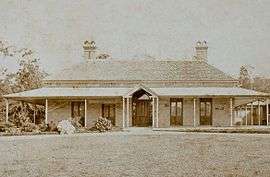
The area remained primarily a farming district until the end of the 19th century, when growth accelerated with the sale of land which housed one of the first homesteads in the area, the 'Granite House' in the area still known as St Johns Wood.
Ashgrove State School opened on 22 January 1877.[8]
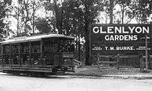
In 1920, the tram line was extended from Red Hill, Queensland to Ashgrove, along Waterworks Road, connecting the suburb with the rest of Brisbane. The tram line closed on Monday 5 August 1968.
Oakleigh State School opened on 29 January 1934.[9]
The Ashgrove Library opened in 1967 with a major refurbishment in 2011.[10]
In 2006, Ashgrove celebrated 'Ashgrove 150', an event organised by the Ashgrove Historical Society to commemorate 150 years of Ashgrove (1856–2006).[11]
Locality amalgamation into the suburb of Ashgrove
Dorrington (originally named the suburb of Oakleigh until 1946)[12] and St Johns Wood were suburbs in their own right until they were absorbed into Ashgrove in 1975. To this day these locality names are still in common use, as many residents still associate their residence locations with these former names.[13][14]
Heritage listings
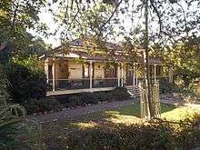
Ashgrove has a number of heritage-listed sites, including:
Facilities
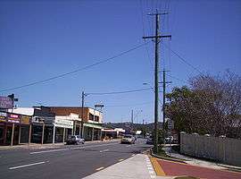
_-_panoramio.jpg)
Ashgrove contains the neighbourhood of Ithaca, which is the home of the Broncos football club. The suburb contains a variety of multicultural restaurants (Thai, Indian, Italian, Japanese, Chinese, Modern Australian), numerous cafes, various shopping amenities (including Coles, Aldi and Woolworths supermarkets).
The Brisbane City Council operates a public library at 87 Amarina Avenue.[20]
Transport
Bus – Ashgrove is serviced by multiple council buses running along Stewart and Waterworks Roads into the central business district. Ashgrove is also a stop on the route of the cross-town Great Circle Line (598/599) which links the four major shopping malls of Brisbane.
It also hosts the northern terminus of the route 61 Maroon CityGlider which is one of two high profile, frequent, and long span "CityGlider" services strongly promoted by the Brisbane City Council. This service provides a cross town function linking Ashgrove with Paddington boutiques and cafes, Suncorp stadium, Caxton Street food and pub precinct, King George Square in the City Centre, Southbank Parklands and cultural district, 'The Gabba', Woolloongabba dining and antique district and Stones Corner cafe strip and outlet shopping.[21]
Cycling – Ashgrove contains two major bike shared paths via Ithaca and Enoggera Creeks which provide a pleasant, mostly flat, off-road and backstreets commuter route to the Royal Brisbane hospital and onwards to the City Centre via the inner northern bikeway. Much of the route winds through pleasant treed parklands.
Education
1940 saw the start of Marist College Ashgrove, with its first headmaster, Brother Ignatius. Other local schools include Ashgrove State School, Mater Dei Catholic Primary School, St Finbarr's Primary School, Oakleigh State School and Mt St Michael's College. Mt St Michael's has an interesting history. In 1925, the Sisters of Charity ventured to Queensland from New South Wales to open a school in Ashgrove. Mt St Michael's College was founded by women of faith in response to the need for Catholic education for the young women of the area. Originally named Grantuly, after the spacious house which housed the school and Convent, the college became known as Mt St Michael's College in 1941.
Clubs and sports
The best known club in the area, GPS Rugby Football Club (known as 'Jeeps'), is one of the oldest established clubs in the area and plays at the Ashgrove Sports Ground, which dates back to 1887. The club has contributed 29 players to the Wallabies.
The ground also hosts the Valley District Cricket Club, which has provided both Queensland Sheffield Shield players and Australian players, including Matthew Hayden and Allan Border,[22] and the Ashgrove Lawn Bowls Club. As well as this, there is a large Scouting group in St Johns Wood.
Ashgrove cricket club has had a long history as a club and in 2015 celebrated its 100th year. Ashgrove cricket club is part of Qld cricket and is part of the Qld sub district association. In the history of the club, home grounds have been at Gibson park Red Hill which is now the home of the Broncos Rugby League club. Other grounds included Dorrington park and The Gap high school was one of the most recent venues up until 2014. Now Ashgrove Cricket home ground is at Everton District AFL situated at Mott Street Enoggera. Players of average to very good are encouraged to participate in a friendly and competitive competition that runs every Saturday from the end of August through March with semi finals and grand finals to round out the competition. Flexibility of availability is a good option for players and can work around those who can play but not every week. Multiple grades cater for ability and availability.
Notable people from Ashgrove
- Corey Brown (footballer) student at Marist College Ashgrove
- Sir Julius Chan, former Prime Minister of Papua New Guinea boarding student at Marist College Ashgrove
- John Connolly, former Wallabies coach student at Marist College Ashgrove
- Des Connor, former rugby union player student at Marist College Ashgrove
- John Eales, former captain of the Wallabies attended Marist College
- Pietro Figlioli, Olympian – water polo student at Marist College Ashgrove
- Ben Griffin, soccer player student at Marist College Ashgrove
- Deryck Guyler (English Actor) emigrated to Australia and retired in Ashgrove until his death in 1999
- Matthew Hayden, Australian and Queensland cricketer student at Marist College Ashgrove
- Daniel Heenan (rugby union) student at Marist College Ashgrove
- Anthony Herbert (Former Australian Rugby Wallaby) attended the Marist School and still lives in Ashgrove
- Daniel Herbert, former rugby union player student at Marist College Ashgrove
- Nick Kruger, Queensland Bulls cricket player
- Bill Ludwig OAM, Australian trade union official, is National President and Queensland state secretary of the Australian Workers' Union (AWU)
- Andrew McGahan, novelist student at Marist College Ashgrove
- Humphrey McQueen, Author and Historian student at Marist College Ashgrove
- Ray Meagher, (actor) student at Marist College Ashgrove
- Sean O'Brien, Australian professional windsurfer and Olympic Sailing Team coach student at Marist College Ashgrove
- Kevin Rudd, Australia's former prime minister boarded at Marist College Ashgrove as a child
- Andrew Stockdale from Wolfmother lived in Ashgrove as a child and attended Ashgrove State School
- Lev Susany, Australian powerlifter and Commonwealth record holder student at Marist College Ashgrove
- Meta Truscott, Australian diarist and Ashgrove historian
- Keith Urban, country music singer (married to Nicole Kidman) attended Ashgrove State School (Primary)[23]
References
- 1 2 3 Australian Bureau of Statistics (27 June 2017). "Ashgrove (State Suburb)". 2016 Census QuickStats. Retrieved 30 July 2017.

- ↑ Australian Bureau of Statistics (31 October 2012). "2011 Community Profiles: Ashgrove (State Suburb)". 2011 Census of Population and Housing. Retrieved 4 October 2012.
- ↑ "Enoggera Ward". Brisbane City Council. Brisbane City Council. Retrieved 12 March 2017.
- ↑ "The Gap Ward". Brisbane City Council. Brisbane City Council. Retrieved 19 March 2017.
- ↑ "Ashgrove (entry 42557)". Queensland Place Names. Queensland Government. Retrieved 18 March 2014.
- ↑ Tom Petrie's Reminiscences of Early Queensland. St Lucia, Queensland: University of Queensland Press. 1992. p. 318. ISBN 0702223832.
- ↑ 'Brisbane's indigenous history'. Retrieved 13 December 2009
- ↑ "Opening and closing dates of Queensland Schools". Department of Education and Training. Queensland Government. Retrieved 31 January 2018.
- ↑ "Opening and closing dates of Queensland schools". Department of Education and Training. Queensland Government. Retrieved 31 January 2018.
- ↑ "Public Libraries Statistical Bulletin 2016-17" (PDF). Public Libraries Connect. State Library of Queensland. November 2017. Archived (PDF) from the original on 30 January 2018. Retrieved 30 January 2018.
- ↑ Ashgrove History Archived 22 September 2008 at the Wayback Machine.. Retrieved 17 October 2009
- ↑ "OAKLEIGH WILL BE NAMED DORRINGTON". The Courier-Mail. Brisbane: National Library of Australia. 24 July 1947. p. 3. Retrieved 1 January 2015.
- ↑ "Towns, suburbs & localities". Renamed Places in Queensland. Archived from the original on 5 June 2014. Retrieved 1 January 2015.
- ↑ "Suburb names lost to history". Brisbane's lost suburbs. ourbrisbane.com. Archived from the original on 19 June 2010.
- ↑ "Residence 'Grove Lodge'". Brisbane Heritage Register. Brisbane City Council. Retrieved 8 February 2015.
- ↑ "Residence 'Grantully'". Brisbane Heritage Register. Brisbane City Council. Retrieved 8 February 2015.
- ↑ "Glen Lyon (entry 600049)". Queensland Heritage Register. Queensland Heritage Council. Retrieved 6 July 2013.
- ↑ "St John's Wood (entry 601506)". Queensland Heritage Register. Queensland Heritage Council. Retrieved 6 July 2013.
- ↑ "Woodlands (entry 601890)". Queensland Heritage Register. Queensland Heritage Council. Retrieved 6 July 2013.
- ↑ "Library opening hours and locations". Brisbane City Council. 3 January 2018. Archived from the original on 30 January 2018. Retrieved 30 January 2018.
- ↑ "CityGlider bus services". Brisbane City Council. Retrieved 3 May 2015.
- ↑ "Valley District Cricket Club". valleydcc.qld.cricket.com.au. Retrieved 2017-01-24.
- ↑ "School History". Ashgrove State School. Retrieved 18 March 2014.
External links
| Wikimedia Commons has media related to Ashgrove, Queensland. |
- University of Queensland: Queensland Places: Ashgrove
- "Ashgrove". BRISbites. Brisbane City Council. Archived from the original on 20 July 2008.
- "Ashgrove". Our Brisbane. Brisbane City Council. Archived from the original on 17 April 2008.
- St Johns Wood Ashgrove website
Coordinates: 27°26′43″S 152°59′31″E / 27.44528°S 152.99194°E