MacGregor, Queensland
| MacGregor Brisbane, Queensland | |||||||||||||||
|---|---|---|---|---|---|---|---|---|---|---|---|---|---|---|---|
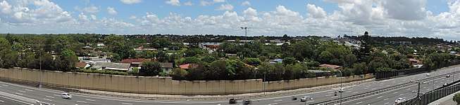 Looking west towards MacGregor suburb, from Upper Mount Gravatt | |||||||||||||||
 MacGregor | |||||||||||||||
| Coordinates | 27°33′53″S 153°04′22″E / 27.5647°S 153.0729°ECoordinates: 27°33′53″S 153°04′22″E / 27.5647°S 153.0729°E | ||||||||||||||
| Population | 5,576 (2011 census)[1] | ||||||||||||||
| • Density | 1,990/km2 (5,160/sq mi) | ||||||||||||||
| Established | 1967 | ||||||||||||||
| Postcode(s) | 4109 | ||||||||||||||
| Area | 2.8 km2 (1.1 sq mi) | ||||||||||||||
| Location | 12 km (7 mi) from Brisbane | ||||||||||||||
| LGA(s) |
City of Brisbane (MacGregor Ward)[2] | ||||||||||||||
| State electorate(s) | Toohey | ||||||||||||||
| Federal Division(s) | Moreton | ||||||||||||||
| |||||||||||||||
MacGregor is a south-side suburb in Brisbane, Queensland, Australia. Its postal code is 4109. MacGregor, like its surrounding suburbs, incorporates a very diverse multicultural community. Previously considered part of Sunnybank, the suburb was named in 1967.
The suburb is in three main parts, divided by the six-lane Kessels Road, and separately, Mimosa Creek. Most residential buildings are single and two-storey beige brick houses with a tiled roof.
Name
The suburb of MacGregor was named after Scottish-born Sir William MacGregor who was the Governor of Queensland from 1909 until 1914.[3] It is spelt MacGregor, not Macgregor although local businesses may have used the latter.
There appears to be no specific naming convention for the roads. Streets on the eastern part of the suburb include a mixture of plant (Freesia, Galliardia) and Scottish (Blairgowrie, Carnoustie) names. On the south-west portion, Angelina and Damson are plum cultivars, Elberta a type of peach, and Jonathan may refer to a type of apple, being some of the agricultural produce that may have been grown in the area before urbanisation.
Demographics
In the 2011 census, the population of MacGregor was 5,576, 51.6% female and 48.4% male. [1]
The median age of the MacGregor population was 32 years of age, 5 years below the Australian median.
Of all people living in MacGregor, 41.9% were born in Australia, compared to the national average of 69.8%; the next most common countries of birth were China 15%, Taiwan 6.3%, India 4.6%, New Zealand 3.3% and Vietnam at 2.3%.
44.4% of people spoke only English at home; the next most popular languages were 20.2% Mandarin, 7.2% Cantonese, 2.7% Vietnamese, 2.3% Korean and 2.2% Greek.
The most common religious affiliation was 'No religion' (25.7%); the next most common responses were Catholic 16.2%, Buddhism 10.0%, Anglican 8.4% and Uniting Church 5.7%.
Education
MacGregor contains two public schools, MacGregor State High School and MacGregor State School (a primary school). The High School, opened in 1969 with nine teachers and 203 students, became notable on 4 November 1973, when a tornado struck the school, creating hundred of thousands of dollars' worth of damage and requiring the rebuilding of much of the school. It now has approximately 1800 students. The primary school was established in 1972 and currently has approximately 2000 students and 50 staff members. Students wears the red MacGregor tartan as part of their school uniform.
Griffith University and the Queensland Sport and Athletics Centre are in the adjoining suburb of Nathan.
Facilities

Additional to the schools, there is a Robertson Scout Group, a large recreational area of the D. M. Henderson Park, and the MacGregor Netball Association playing fields. The park was named after local resident Daniel Murray Henderson (c. 1871 – 3 July 1954), who was a strawberry and small crops farmer.[4][5] Henderson lived on Mains Road, near the intersection with Fleetwood Street, MacGregor.
Local residents use either the Westfield Garden City Shopping Centre at Upper Mount Gravatt or the Sunnybank shopping centres (Sunnybank, Sunny Park, Market Square). Sunny Park Shopping Centre is on the MacGregor suburb corner boundary.
Public transport in the area to Brisbane City is by bus at the MacGregor park-and-ride, or the nearby Garden City Interchange or Eight Mile Plains busway station. The nearest Queensland Rail suburban railway stations are Altandi, Sunnybank, Banoon or Coopers Plains.
Either side of Kessels Road are large business retail outlet premises as well as a driver licence testing centre.
Mimosa Creek, a tributary to the Bulimba Creek is part of a nature reserve network including the nearby Toohey Forest Conservation Park.
Gallery
 Kessels Road, looking west.
 Looking over the suburb towards the sports stadium.
 MacGregor suburb on left of Pacific Motorway.
 A western-side suburban street.
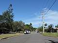 An eastern-side suburban street.
 MacGregor State High School side entrance.
 MacGregor State High School oval.
References
- 1 2 Australian Bureau of Statistics (31 October 2012). "MacGregor (State Suburb)". 2011 Census QuickStats. Retrieved 26 October 2014.

- ↑ "MacGregor Ward". Brisbane City Council. Brisbane City Council. Retrieved 12 March 2017.
- ↑ "MacGregor (entry 50174)". Queensland Place Names. Queensland Government. Retrieved 20 January 2018.
- ↑ "Do you know your Brisbane?". Sunday Mail (321). Queensland, Australia. 21 July 1929. p. 22. Retrieved 27 January 2018 – via National Library of Australia.
- ↑ "The C.O.D. and the Cane Prices Board". The Telegraph (16, 407). Queensland, Australia. 2 July 1925. p. 11. Retrieved 27 January 2018 – via National Library of Australia.
External links
- University of Queensland: Queensland Places: MacGregor
- MacGregor State School
- MacGregor State High School
- Brisbane City Council Suburb Map
- ourbrisbane.com - MacGregor