Sherwood, Queensland
| Sherwood Brisbane, Queensland | |||||||||||||||
|---|---|---|---|---|---|---|---|---|---|---|---|---|---|---|---|
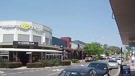 Sherwood Central shops on Sherwood Road | |||||||||||||||
 Sherwood | |||||||||||||||
| Coordinates | 27°31′53″S 152°58′48″E / 27.53139°S 152.98000°ECoordinates: 27°31′53″S 152°58′48″E / 27.53139°S 152.98000°E | ||||||||||||||
| Population | 5,313 (2016 census)[1] | ||||||||||||||
| Postcode(s) | 4075 | ||||||||||||||
| Location | 8.2 km (5 mi) from Brisbane CBD | ||||||||||||||
| LGA(s) |
City of Brisbane (Tennyson Ward)[2] | ||||||||||||||
| State electorate(s) | |||||||||||||||
| Federal Division(s) | Moreton | ||||||||||||||
| |||||||||||||||
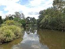
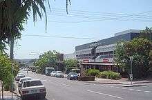
Sherwood is a suburb of the City of Brisbane, Queensland, Australia.[3] It is 8.3 kilometres (5.2 mi) south west of the Brisbane CBD [5] and borders the Brisbane River. The suburb is mostly low and medium-density housing with a retail strip centred along Sherwood Road. At the 2016 Australian Census the suburb recorded a population of 5,313.[1]
Demographics
In the 2016 census, the population of Sherwood was 5,313, 52.9% female and 47.1% male.[1] The median age of the Sherwood population was 35 years, three years below the Australian median. 71.2% of people living in Sherwood were born in Australia, similar to the national average of 66.7%. The other top responses for country of birth were England 5.0%, New Zealand 2.5%, India 1.9%, South Korea 0.9%, China (excluding SARs and Taiwan) 0.8%. 82.3% of people spoke only English at home; other languages include 1.3% Mandarin, 1.0% Korean, 0.8% Spanish, 0.7% Persian, 0.7% Hindi.[1]
Heritage listings
Sherwood has a number of heritage-listed sites, including:
- 464 Oxley Road: Sherwood State School[6]
- Sherwood Road: Berry and MacFarlane Monument[7]
- 39A Turner Street: Sherwood Arboretum, a large botanical garden and lake fronting the river which was planned and landscaped in the 1920s.[8]
Commercial area
There are a number of cafes, including the Coffee Club, and a Woolworths supermarket.
Transport
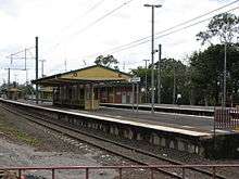
The suburb is serviced by the Sherwood Railway Station which links Ipswich and the Springfield Central lines to the Brisbane central business district. Bus services along Oxley Road link the Centenary suburbs to Indooroopilly and the Great Circle Line service passes through the suburb.
Education
Sherwood State School, established in 1867 is one of the oldest schools in the state and still has preserved many of its original timber buildings.
Sherwood State School was originally known as West Oxley State School and opened on 25 March 1867[9] (other records indicate 23 March). The first head teacher (Headmaster) appointed to the school was Major William Jenyns Boyd. He was born in Paris in 1842 and migrated to Australia in 1862.
In 1868, Oliver Radcliffe was the first name on the roll as a pupil teacher. He became a teacher, a headmaster and then a school inspector. By his retirement in 1932, he was the Chief Inspector for the Queensland Education Department. He personally inspected schools from Coolangatta to Thursday Island and from Rockhampton to the border with South Australia.[10]
Other significant 'finger prints' in Sherwood State School's heritage include:
1874 – School builds first Water Closet (toilet);
1878 – School changed its name to Sherwood State School.
1890 – Shingle roofing replaced with corrugated iron;
1893 – Measles and influenza out break reported;
1914 – World War 1;
1917 – Three additional classrooms added;
1925 – Students planted 100 trees in school grounds;
1926 – Limited electricity was provided;
1927 – 33 additional 3 acres (12,000 m2) of land purchased;
1928 – First telephone installed
1936 – Three more classrooms added; electrical gramophone and wireless (radio) provided to the school
1937 – School moved to its current location/site.
1939 – World War II began with a first aid, ambulance post and air raid trenches placed under buildings;
1950 – Polio outbreak;
1959 – School enrolment peaked at 1034 students;
1962 – Tuck Shop opened;
1965 – Parent and Citizen's Association was formed; tennis court resealed and fenced;
1967 – Pool opened;
1984 – School purchased first computer;
1991 – After school care services established;
2000 – School Hall opens;
2006 – Preparatory building constructed
2007 – Inaugural prep class commences
2012 – New Sports Hall;
2017- School celebrated 150th Anniversary;
Clubs
The Sherwood Sharks swimming club uses the Sherwood State School Pool.
References
- 1 2 3 4 Australian Bureau of Statistics (27 June 2017). "Sherwood (Brisbane City) (State Suburb)". 2016 Census QuickStats. Retrieved 9 August 2018.

- ↑ "Tennyson Ward". Brisbane City Council. Brisbane City Council. Retrieved 19 March 2017.
- 1 2 "Sherwood (entry 43029)". Queensland Place Names. Queensland Government. Retrieved 27 July 2014.
- ↑ "Brisbane City (suburb) (entry 46580)". Queensland Place Names. Queensland Government. Retrieved 27 July 2014.
- ↑ Distance calculated based on coordinates given in [3] and [4]
- ↑ "Sherwood State School (entry 650032)". Queensland Heritage Register. Queensland Heritage Council. Retrieved 10 February 2018.
- ↑ "Berry & MacFarlane Monument (entry 600292)". Queensland Heritage Register. Queensland Heritage Council. Retrieved 19 June 2013.
- ↑ "Sherwood Arboretum (including the John Herbert Memorial Vista) (entry 602456)". Queensland Heritage Register. Queensland Heritage Council. Retrieved 19 June 2013.
- ↑ "Sherwood State School: History". Department of Education, Training and Employment. Retrieved 23 December 2014.
- ↑ "HAPPY RETIREMENT". The Brisbane Courier. Qld.: National Library of Australia. 6 February 1932. p. 16. Retrieved 12 October 2013.
Further reading
- Schneider, Laurel; Jones, Robyn; Sherwood State School Parents' and Citizens' Association (1992), The shaping of Sherwood : a history of Sherwood State School, 1867-1992, Sherwood State School, ISBN 978-0-646-08775-7
External links
| Wikimedia Commons has media related to Sherwood, Queensland. |
- University of Queensland: Queensland Places: Sherwood
- Brisbane Suburb Home: Sherwood via the Way Back Machine