Hemmant, Queensland
| Hemmant Brisbane, Queensland | |||||||||||||||
|---|---|---|---|---|---|---|---|---|---|---|---|---|---|---|---|
.jpg) Canoe ramp at Fleming Road Park, Hemmant | |||||||||||||||
| Population | 2,594 (2011 census)[1] | ||||||||||||||
| Postcode(s) | 4174[2] | ||||||||||||||
| Location | 11 km (7 mi) east of Brisbane CBD[3] | ||||||||||||||
| LGA(s) |
City of Brisbane (Doboy Ward)[4] | ||||||||||||||
| State electorate(s) | Lytton | ||||||||||||||
| Federal Division(s) | Bonner | ||||||||||||||
| |||||||||||||||
Hemmant is a suburb of Brisbane, Australia. It is 11 kilometres (6.8 mi) east of the CBD located on the Brisbane River.[3]
History


In 1858 the land of Hemmant area was sold for fruit, vegetable growing and farming in general. Early 1860s Sugar cane was farmed and mills were built to process the cane. Gibsons Clydesdale mill was well known as was a co-operative mill at Murarrie in 1872. Part of Hemmant was originally known as "Doughboy Creek" The whole district had been named after William Hemmant[5] a local parliamentarian in 1876. He was treasurer in the Macalister government and between 1873 and 1876 represented the Bulimba electorate.[3]
.jpg)
The Queensport Aquarium theme park opened at Hemmant in 1889 but had closed by the late 1890s.[6]
Population growth
| Census Date | Population |
|---|---|
| 1911 | 292 |
| 1921 | 432 |
| 1947 | 614 |
| 1976 | 1,426 |
| 1991 | 1,579 |
| 2001 | 2,209 |
| 2006 | 2,680[7] |
| 2011 | 2,594[1] |
Demographics
In the 2011 census, Hemmant recorded a population of 2,594 people, 50.4% female and 49.6% male.
The median age of the Hemmant population was 34 years of age, 3 years below the Australian median.
74.9% of people living in Hemmant were born in Australia, compared to the national average of 69.8%; the next most common countries of birth were New Zealand 8.2%, England 3.3%, Philippines 1.6%, Fiji 0.8%, China 0.5%.
88.4% of people spoke only English at home; the next most common languages were 0.8% Cantonese, 0.8% Hindi, 0.5% Tagalog, 0.5% Filipino, 0.5% Vietnamese.
Heritage listings

Hemmant has a number of heritage-listed sites, including:
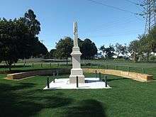
- cnr Boonoo Street: Anning Monument (Boer War Memorial)[8]
- 56 Hemmant-Tingalpa Road: Hemmant State School and Dumbarton[9]
- 69 Hemmant Road: Hemmant Christian Community Church[10]
- 241, 228 and 274 Fleming Road: Hemmant Gun Battery[11]
Schools
In 1864 a primary school was opened. The Hemmant State School closed down in 2010. At that time, it was Queenslands oldest continually operating school. The school closure was part of the State Schools of Tomorrow Project. The School site remains and has been reoponed as the Hemmant Flexible Learning Centre, affiliated with the Catholic Church. Originally named Bulimba Creek, it was renamed Doughboy Creek in 1866 and then changed to Hemmant in 1878.[3]
Leisure
In 1889 a zoo and aquarium were opened at Aquarium Avenue. Visitors arrived by riverboats until the 1893 flood. The animals were rescued but the attractions were closed down. The building was used as dance hall until 1901.[3]
In 1988 an old quarry site became the Hemmant Quarry Reserve, next to the Hemmant Cemetery. The reserve is 24 hectares and has walking tracks and picnic facilities.[12]
Transport
Hemmant railway station provides access to regular Queensland Rail City network services to Brisbane and Cleveland.
References
- 1 2 Australian Bureau of Statistics (31 October 2012). "Hemmant, Qld (State Suburb)". 2011 Census QuickStats. Retrieved 23 October 2013.

- ↑ "Find a postcode". Australia Post. Retrieved 24 October 2013.
- 1 2 3 4 5 Queensland places
- ↑ "Doboy Ward". Brisbane City Council. Retrieved 4 March 2017.
- ↑ Brisbane Community Pofiles
- ↑ 'Tiger, Roller-Coasters and Special Effects: Brisbane's 19th-Century Dreamworld'.
- ↑ "2006 Census QuickStats : Hemmant (Brisbane City) (State Suburb)". Australian Bureau of Statistics. Retrieved 24 October 2013.
- ↑ "Anning Monument (Boer War Memorial) (entry 600220)". Queensland Heritage Register. Queensland Heritage Council. Retrieved 19 June 2013.
- ↑ "Hemmant State School and Dumbarton (entry 602382)". Queensland Heritage Register. Queensland Heritage Council. Retrieved 19 June 2013.
- ↑ "Hemmant Christian Community Church (entry 600221)". Queensland Heritage Register. Queensland Heritage Council. Retrieved 19 June 2013.
- ↑ "6 (390) Australian Anti-Aircraft Battery (entry 601353)". Queensland Heritage Register. Queensland Heritage Council. Retrieved 19 June 2013.
- ↑ Brisbane QLD
External links
![]()
Coordinates: 27°27′00″S 153°08′00″E / 27.45°S 153.133333°E