Banyo, Queensland
| Banyo Brisbane, Queensland | |||||||||||||||
|---|---|---|---|---|---|---|---|---|---|---|---|---|---|---|---|
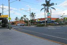 Shopping village in Banyo | |||||||||||||||
| Population | 5,607 (2011 census)[1] | ||||||||||||||
| • Density | 1,078/km2 (2,793/sq mi) | ||||||||||||||
| Postcode(s) | 4014 | ||||||||||||||
| Area | 5.2 km2 (2.0 sq mi) | ||||||||||||||
| Location | 13 km (8 mi) from Brisbane cbd | ||||||||||||||
| LGA(s) |
City of Brisbane (Northgate Ward)[2] | ||||||||||||||
| State electorate(s) | Nudgee | ||||||||||||||
| Federal Division(s) | Lilley | ||||||||||||||
| |||||||||||||||
Banyo is a northern suburb of the City of Brisbane, Queensland, Australia.[3] It is a community split between residential and industrial land usage, the latter being attracted by the accessibility of local transport, including the Gateway Motorway.
Geography
Banyo and the neighbouring suburb Nudgee, with which it is intertwined in many respects, are both rich in local history. This history includes the recent preservation of an Aboriginal Bora Ring. The areas of Nudgee and Nudgee Beach border on the Boondall Wetlands, which is protected by the Brisbane City Council.
Banyo has vastly increased the number of its business and industrial parks in recent years due to its close proximity to Brisbane Airport and the nearby Port of Brisbane. Nudgee Road is progressively becoming a commercial hub due to its connection to the Gateway Motorway, with a large service centre and petrol station and with new industrial grounds under construction overlooking the motorway itself.
The Australian Catholic University chose to establish its Brisbane campus on the site of the former Pius XII Seminary, which boosted the housing market within Banyo.
A new residential estate, 'Couture', has recently been developed on the site of an old Army depot lying adjacent to the Golden Circle cannery based in next-door Northgate. Another new residential estate, 'Vitale' has also recently been constructed nearby.
Banyo's commercial centre (the area surrounding Banyo railway station) has recently been enhanced following a Brisbane City Council Suburban Community Improvement Project (SCIP).
History
The Banyo Library opened in 1981 with a major refurbishment in 2009.[4]
Demographics
In the 2016 census, Banyo recorded a population of 5,868 people, 49.7% female and 50.3% male.
The median age of the Banyo population was 37 years of age. 72.2% of people living in Banyo were born in Australia, compared to the national average of 66.7%; the next most common countries of birth were New Zealand 5.3%, India 3.1%, England 2.4%, Philippines 2.0%, China 0.9%.
81.8% of people spoke only English at home; the next most popular languages were 1.6% Punjabi, 1.1% Mandarin, 1.0% Hindi, 0.9% Vietnamese.[5]
Transport
Banyo railway station provides access to regular Queensland Rail City network services to Brisbane and Shorncliffe. The 306 bus service operated by Brisbane Transport also goes to the Cultural Centre via Fortitude Valley.[6]
Banyo station has recently undergone an upgrade. The upgrade included restoring the 100-year-old station building, toilet upgrade, new and improved station furniture and signage, fresh painting and station cleaning.
The Australian Catholic University operates a free bus for students that runs from Toombul to the university via Northgate station and another bus between the university and Westfield Chermside.
Amenities
The Brisbane City Council operates a public library at 284 St Vincents Road.[7]
Sport
Despite its name, the Virginia Golf Club is located at Elliott Road, Banyo.[8] Supercars team Triple Eight Race Engineering is based in Banyo.[9]
References
- ↑ Australian Bureau of Statistics (31 October 2012). "Banyo". 2011 Census QuickStats. Retrieved 25 October 2013.

- ↑ "Northgate Ward". Brisbane City Council. Brisbane City Council. Retrieved 12 March 2017.
- ↑ "Banyo (entry 47655)". Queensland Place Names. Queensland Government. Retrieved 22 March 2014.
- ↑ "Public Libraries Statistical Bulletin 2016-17" (PDF). Public Libraries Connect. State Library of Queensland. November 2017. Archived (PDF) from the original on 30 January 2018. Retrieved 30 January 2018.
- ↑ Australian Bureau of Statistics, 2016 Quick Census Stats
- ↑ TransLink Transit Authority, Bus timetables, archived from the original on 2010-11-14, retrieved 8 July 2013
- ↑ "Library opening hours and locations". Brisbane City Council. 3 January 2018. Archived from the original on 30 January 2018. Retrieved 30 January 2018.
- ↑ "Virginia Golf Club". Virginia Golf Club. Retrieved 28 April 2014.
- ↑ "Gen 2 rules triggered Triple Eight expansion". Speedcafe. 6 March 2015.
External links
| Wikimedia Commons has media related to Banyo, Queensland. |
- University of Queensland: Queensland Places: Banyo
- "Banyo". BRISbites. Brisbane City Council. Archived from the original on 20 July 2008.
- "Banyo". Our Brisbane. Brisbane City Council. Archived from the original on 22 February 2008.
Coordinates: 27°22′34″S 153°04′44″E / 27.37611°S 153.07889°E