Eichstätt (district)

Kreis Eichstätt
District
Country  Germany
State Bavaria
Adm. region Upper Bavaria
Capital Eichstätt
Area
  Total 1,214 km2 (469 sq mi)
Population (31 December 2017)[1]
  Total 131,646
  Density 110/km2 (280/sq mi)
Time zone UTC+01:00 (CET)
  Summer (DST) UTC+02:00 (CEST)
Vehicle registration EI
Website landkreis-eichstaett.de

Eichstätt is a Landkreis (district) in Bavaria, Germany. It is bounded by (from the south and clockwise) the districts of Neuburg-Schrobenhausen, Donau-Ries, Weißenburg-Gunzenhausen, Roth, Neumarkt, Kelheim and Pfaffenhofen, and by the city of Ingolstadt.

History

The district of Eichstätt in its present form was established in 1972 by merging the former district of Eichstätt with parts of the dissolved districts of Ingolstadt, Beilngries, Riedenburg and Hilpoltstein. The city of Eichstätt lost its status as a district-free city and became the capital of the new district. Today the Eichstätt district has powerful economic structures. The rate of jobless people is only 1.2% (June 2011).

Geography

The district is located in the southern part of the Frankish Alb. 80% of the district are situated in the Altmühltal Nature Park. In the southeast the Danube forms a short part of the border.

Coat of arms

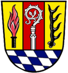
The coat of arms displays:
  • a torch, symbolising the industrial area within the metropolitan area of Ingolstadt
  • a crosier, symbolising the bishopric of Eichstätt
  • an antler, symbolising the medieval county of Hirschberg (German Hirsch = "deer")
  • the blue and white checkered pattern of Bavaria

Towns and municipalities

Towns and municipalities in Landkreis Eichstätt
Towns Municipalities
  1. Beilngries
  2. Eichstätt
  1. Adelschlag
  2. Altmannstein
  3. Böhmfeld
  4. Buxheim
  5. Denkendorf
  6. Dollnstein
  7. Egweil
  8. Eitensheim
  9. Gaimersheim
  10. Großmehring
  11. Hepberg
  12. Hitzhofen
  13. Kinding
  14. Kipfenberg
  1. Kösching
  2. Lenting
  3. Mindelstetten
  4. Mörnsheim
  5. Nassenfels
  6. Oberdolling
  7. Pförring
  8. Pollenfeld
  9. Schernfeld
  10. Stammham
  11. Titting
  12. Walting
  13. Wellheim
  14. Wettstetten

References

  1. "Fortschreibung des Bevölkerungsstandes". Bayerisches Landesamt für Statistik und Datenverarbeitung (in German). September 2018.

Coordinates: 48°55′N 11°20′E / 48.92°N 11.33°E / 48.92; 11.33

This article is issued from Wikipedia. The text is licensed under Creative Commons - Attribution - Sharealike. Additional terms may apply for the media files.