Kelheim (district)
| Kelheim | |
|---|---|
| District | |
 | |
| Country |
|
| State | Bavaria |
| Adm. region | Lower Bavaria |
| Capital | Kelheim |
| Area | |
| • Total | 1,067 km2 (412 sq mi) |
| Population (31 December 2017)[1] | |
| • Total | 121,119 |
| • Density | 110/km2 (290/sq mi) |
| Time zone | UTC+01:00 (CET) |
| • Summer (DST) | UTC+02:00 (CEST) |
| Vehicle registration | KEH |
| Website | landkreis-kelheim.de |
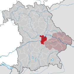
Kelheim is a Landkreis (district) in Bavaria, Germany, bound (from the north and clockwise) by the regions Regensburg, Landshut, Freising, Pfaffenhofen, Eichstätt and Neumarkt.
Geography
The district is located halfway between Ingolstadt and Regensburg on both banks of the Danube. In the northwestern part it includes a part of the Altmühl Valley Nature Park and the confluence of Altmühl and Danube.
Coat of arms
 |
The coat of arms displays:
|
Towns and municipalities
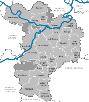
Towns and municipalities in Landkreis Kelheim
| Towns | Municipalities | |
|---|---|---|
References
- ↑ "Fortschreibung des Bevölkerungsstandes". Bayerisches Landesamt für Statistik und Datenverarbeitung (in German). September 2018.
External links
| Wikimedia Commons has media related to Landkreis Kelheim. |
- Official website (German)
- Altmühltal Nature Park (German, English)
Towns and municipalities in Kelheim (district) | ||
|---|---|---|
Coordinates: 48°50′N 11°50′E / 48.83°N 11.83°E
| Authority control |
|---|
This article is issued from
Wikipedia.
The text is licensed under Creative Commons - Attribution - Sharealike.
Additional terms may apply for the media files.