History
Kronach was ruled by the bishopric of Bamberg from 1102 until 1803, when the clerical states of Germany were dissolved. Afterwards it fell to Bavaria, where the districts of Kronach and Teuschnitz were established on the territory of the present district. In 1931 these districts were merged in order to form the district of Kronach.
Geography
A large portion of the district is part of the Franconian Forest nature park. The Franconian Forest (German Frankenwald) is a hill chain rising to 795 metres (2,608 ft) To the southwest the country is sloping away. Several narrow rivers run southwards through the district in order to join the Main River beyond the district's borders, among them the Kronach River.
Coat of arms
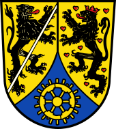 Coat of arms |
The coat of arms displays:
- the heraldic lion of Bamberg
- the heraldic lion of Orlamünde (a Thuringian family owning Lauenstein castle in the very north of the district)
- the wheel symbolising watermills in the rivers of the district
|
Towns and municipalities

Towns and municipalities in Landkreis Kronach

