Fürstenfeldbruck (district)
| Fürstenfeldbruck | |||
|---|---|---|---|
| District | |||
| |||
 | |||
| Country |
| ||
| State | Bavaria | ||
| Adm. region | Upper Bavaria | ||
| Capital | Fürstenfeldbruck | ||
| Area | |||
| • Total | 435 km2 (168 sq mi) | ||
| Population (31 December 2017)[1] | |||
| • Total | 217,831 | ||
| • Density | 500/km2 (1,300/sq mi) | ||
| Time zone | UTC+01:00 (CET) | ||
| • Summer (DST) | UTC+02:00 (CEST) | ||
| Vehicle registration | FFB | ||
| Website | http://www.lra-ffb.de | ||
Fürstenfeldbruck is a Landkreis (district) in Bavaria, Germany. It is bounded by (from the east and clockwise) the city of Munich and the districts of Munich, Starnberg, Landsberg, Aichach-Friedberg and Dachau.
History
In medieval times the region was a clerical state ruled by the abbey of Fürstenfeld. When the clerical states of Holy Empire were dissolved in 1803, the territory was annexed by Bavaria. The district of Fürstenfeldbruck was established in 1939.
Geography
The district is occupied by the western Munich metropolitan area. It has the highest population density of all Bavarian districts. More than 90 percent of the population live in the eastern half of the district, which includes the suburbs of Munich.
Coat of arms
 Coat of arms |
|
Towns and municipalities
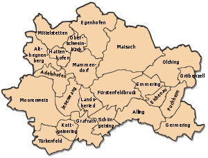

| Towns | Municipalities | |
|---|---|---|
References
- ↑ "Fortschreibung des Bevölkerungsstandes". Bayerisches Landesamt für Statistik und Datenverarbeitung (in German). September 2018.
External links
| Wikimedia Commons has media related to Landkreis Fürstenfeldbruck. |
- Official website (in German)
- Regional news platform for the Landkreis Fürstenfeldbruck (in German)
Towns and municipalities in Fürstenfeldbruck district | ||
|---|---|---|
This article is issued from
Wikipedia.
The text is licensed under Creative Commons - Attribution - Sharealike.
Additional terms may apply for the media files.