Neustadt (Aisch)-Bad Windsheim
| Neustadt (Aisch)-Bad Windsheim | |
|---|---|
| District | |
 | |
| Country |
|
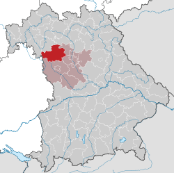
| State | Bavaria |
| Adm. region | Middle Franconia |
| Capital | Neustadt (Aisch) |
| Area | |
| • Total | 1,267.54 km2 (489.40 sq mi) |
| Population (31 December 2017)[1] | |
| • Total | 99,641 |
| • Density | 79/km2 (200/sq mi) |
| Time zone | UTC+01:00 (CET) |
| • Summer (DST) | UTC+02:00 (CEST) |
| Vehicle registration | NEA, SEF, UFF |
| Website | http://www.landkreis-nea.de |
Neustadt (Aisch)-Bad Windsheim (German: Landkreis Neustadt an der Aisch-Bad Windsheim, official Landkreis Neustadt a.d.Aisch-Bad Windsheim) is a Landkreis (district) in Bavaria, Germany. It is bounded by (from the west and clockwise) the districts of Würzburg, Kitzingen, Bamberg, Erlangen-Höchstadt, Fürth and Ansbach, and by the state of Baden-Württemberg (district Main-Tauber).
History
The district was established in 1972 by merging the former districts of Neustadt (Aisch), Uffenheim and Scheinfeld.
Geography
The district is covered by the Steigerwald and Frankenhöhe nature parks, both comprising large forested and hilly areas. The Aisch, a small affluent of the Regnitz River, runs through the district from southwest to northeast, with all main towns of the district on its banks.
Economy
In 2013 (latest data available) the GDP per inhabitant was €24,247. This places the district 82nd out of 96 districts (rural and urban) in Bavaria (overall average: €39,691).[2]
Coat of arms
 |
The coat of arms displays:
|
Towns and municipalities
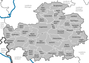
Towns:
Municipalities:
- Baudenbach
- Burghaslach
- Dachsbach
- Diespeck
- Dietersheim
- Emskirchen
- Ergersheim
- Gallmersgarten
- Gerhardshofen
- Gollhofen
- Gutenstetten
- Hagenbüchach
- Hemmersheim
- Illesheim
- Ippesheim
- Ipsheim
- Langenfeld
- Markt Bibart
- Markt Erlbach
- Markt Nordheim
- Markt Taschendorf
- Marktbergel
- Münchsteinach
- Neuhof an der Zenn
- Oberickelsheim
- Obernzenn
- Oberscheinfeld
- Simmershofen
- Sugenheim
- Trautskirchen
- Uehlfeld
- Weigenheim
- Wilhelmsdorf
References
- ↑ "Fortschreibung des Bevölkerungsstandes". Bayerisches Landesamt für Statistik und Datenverarbeitung (in German). September 2018.
- ↑ "VGR der Länder, Kreisergebnisse für Deutschland - Bruttoinlandsprodukt, Bruttowertschöpfung in den kreisfreien Städten und Landkreisen der Bundesrepublik Deutschland 2000 bis 2013 (German)". Statistische Ämter der Länder und des Bundes. Retrieved 1 June 2016.
External links
| Wikimedia Commons has media related to Landkreis Neustadt an der Aisch-Bad Windsheim. |
- Official website (German)
Coordinates: 49°35′N 10°30′E / 49.58°N 10.5°E
| Authority control |
|---|