Stammham, Eichstätt
| Stammham | ||
|---|---|---|
| ||
 Stammham Location of Stammham within Eichstätt district 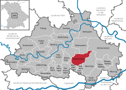 | ||
| Coordinates: 48°51′N 11°28′E / 48.850°N 11.467°ECoordinates: 48°51′N 11°28′E / 48.850°N 11.467°E | ||
| Country | Germany | |
| State | Bavaria | |
| Admin. region | Oberbayern | |
| District | Eichstätt | |
| Government | ||
| • Mayor | Hans Meier (UW) | |
| Area | ||
| • Total | 39.04 km2 (15.07 sq mi) | |
| Elevation | 483 m (1,585 ft) | |
| Population (2017-12-31)[1] | ||
| • Total | 4,022 | |
| • Density | 100/km2 (270/sq mi) | |
| Time zone | CET/CEST (UTC+1/+2) | |
| Postal codes | 85134 | |
| Dialling codes | 08405 | |
| Vehicle registration | EI | |
| Website | www.stammham.de | |

Stammham is a municipality in the district of Eichstätt in Bavaria in Germany.
History
During the French invasion in Russia six men of Stammham lost their lives. 17 people died from cholera in 1873. During the First World War 26 men lost their lives. 1921 / 1922: electrification. During the Second World War 58 people lost their lives.[2]
References
| Wikimedia Commons has media related to Stammham, Eichstätt. |
This article is issued from
Wikipedia.
The text is licensed under Creative Commons - Attribution - Sharealike.
Additional terms may apply for the media files.