Amberg
| Amberg | ||
|---|---|---|
 | ||
| ||
 Amberg | ||
| Coordinates: 49°26′40″N 11°50′54″E / 49.44444°N 11.84833°ECoordinates: 49°26′40″N 11°50′54″E / 49.44444°N 11.84833°E | ||
| Country | Germany | |
| State | Bavaria | |
| Admin. region | Oberpfalz | |
| District | Urban district | |
| Government | ||
| • Lord Mayor | Michael Cerny (CSU) | |
| Area | ||
| • Total | 50.04 km2 (19.32 sq mi) | |
| Elevation | 374 m (1,227 ft) | |
| Population (2017-12-31)[1] | ||
| • Total | 42,248 | |
| • Density | 840/km2 (2,200/sq mi) | |
| Time zone | CET/CEST (UTC+1/+2) | |
| Postal codes | 92224 | |
| Dialling codes | 09621 | |
| Vehicle registration | AM | |
| Website | www.amberg.de | |

Amberg (German pronunciation: [ˈambɛrk] (![]()
History
The town was first mentioned in 1034, at that time under the name Ammenberg. It became an important trading centre in the Middle Ages, exporting mainly iron ore and iron products. In 1269, together with Bamberg, the town became subordinate to the Wittelsbach dynasty that ruled Bavaria.
In 1329 the town and the entire Upper Palatinate fell to a branch line of the Wittelsbach family and was no longer part of the duchy of Bavaria. Although in geographic terms it was regarded as Bavarian and the region was part of the Bavarian circle in the organization of the Imperial Circles. The rulers of Upper Palatinate were open-minded towards Protestantism. In the 16th century the town turned to Lutheranism, but attempts of the ruling family to introduce the more radical Calvinism failed due to the reluctance of its citizens.
In 1628 Amberg and Upper Palatinate became part of the electorate of Bavaria. The inhabitants were given the choice: return to Catholicism or leave the town forever. Many families left the town and fled to the Free Imperial Cities of Regensburg and Nuremberg.
On 24 August 1796, during the French Revolutionary Wars, the city and its environs were the locale of a major battle at which 35,000 French, under the command of Jean Baptiste Jourdan fought with 40,000 Austrians under the command of Archduke Charles; the French suffered significantly more losses in this Austrian victory. Amberg was the regional capital of Upper Palatinate until 1810 when power was transferred to the larger city of Regensburg.
After World War II, when Bavaria fell into the American Sector, Amberg was home to Pond Barracks, a United States Army post. I.F.Stone writes about it in his book Underground to Palestine (pp. 31ff). The post was closed in 1992 and the facility turned over to the local community for housing, most of it for social housing.
Jewish History
Jews had settled in Amberg before 1294, when the first documentation can be found. Shortly after, in 1298, thirteen of the town Jews died during the Rindfleisch massacres.[2] Nevertheless, in 1347 six families received permission to settle in Amberg and twenty years after, in 1367, a Yeshivah was opened in it, though the Jewish community was expelled from Amberg in 1403.[2] Upon the expulsion, the synagogue was annexed to the nearby church.[3] Twelve Jews remained in town in 1942. The few survivors returned to the town after 1945, and a displaced persons camp named Amberg - located nearby the town - housed mostly Jewish refugees and survivors.[4] As a result of immigration from the former USSR to Germany, the Jewish population in town grew to about 275 in 2003.[2] A synagogue exists in town nowadays.
Lord mayors
- 1866–1892: Vincent König
- 1892–1907: Josef Heldmann
- 1907–1913: Georg Schön
- 1913–1933: Eduard Klug, BVP
- 1933: Otto Saugel (temporary)
- 1933–1945: Josef Filbig, NSDAP
- 1945–1946: Christian Endemann, SPD
- 1946: Eduard Klug
- 1946: Christian Endemann, SPD
- 1946–1952: Michael Lotter, CSU
- 1952–1958: Josef Filbig, Deutsche Gemeinschaft (Deutschland)
- 1958–1970: Wolf Steininger, CSU
- 1970–1990: Franz Precht], CSU
- 1990–2014: Wolfgang Dandorfer, CSU
- since 2014: Michael Cerny, CSU
Population development
Data source:[5]
| Year | Inhabitants | Year | Inhabitants | Year | Inhabitants |
|---|---|---|---|---|---|
| 1400 | 2.720 | 1800 | 5.763 | 1939 | 31.775 |
| 1450 | 2.980 | 1840 | 11.793 | 1946 | 36.795 |
| 1500 | 3.180 | 1859 | 12.312 | 1950 | 37.920 |
| 1550 | 3.730 | 1871 | 13.005 | 1960 | 41.849 |
| 1600 | 4.280 | 1880 | 14.583 | 1970 | 41.345 |
| 1630 | 4.910 | 1890 | 19.126 | 1980 | 44.264 |
| 1648 | 3.274 | 1900 | 22.039 | 1990 | 43.111 |
| 1700 | 3.720 | 1910 | 25.242 | 2000 | 43.794 |
| 1713 | 1.900 | 1919 | 26.009 | 2010 | 43.755 |
| 1750 | 4.537 | 1925 | 28.387 | 2014 | 41.535 |
Sights
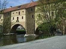
A defining feature of the town is the Stadtbrille (literally: town spectacles) – a bridge, originally a part of the town fortifications, whose arches reflected on the river waters resemble a pair of spectacles.
Other tourist attractions in Amberg include:
- Market Square, which contains the Gothic town hall (built in 1358) and the late-Gothic parish church of St. Martin
- The New Palace, the former residence of the counts of the Rhenish Palatinate, built at the beginning of the 15th century and renovated in 1603

- A well-preserved section of the medieval walls and gates
- The baroque Franciscan monastery on the Hill of Our Lady Help of Christians (Germ. Mariahilfberg) above the town. This hill was given its name during the bubonic plague in the Thirty Years' War in 1633/4 when the locals beseeched the Virgin Mary to rid them of the plague.
- The 'Little Wedding House' (local German dialect Eh’häusl), claimed by town authorities to be the world's smallest hotel. Built in 1728, the 2 metre wide hotel was 'sold' to young couples for one night to circumvent laws prohibiting marriages between poor people.[6]
- The town museum (Stadtmuseum Amberg) includes exhibits on life and industry in Amberg, the history of clothing and works of Michael Mathias Prechtl and houses travelling exhibitions.[7][8][9]
- Air Museum (Luftmuseum), opened in 2006.[10][11]
International relations
Amberg is twinned with:


Notable people
- Karl Addicks (born 1950), politician (FDP), Member of Bundestag 2004-2009
- Hans Aumeier (1906–1948), Nazi SS officer in a leading position in several concentration camps executed for war crimes
- Hans Baumann (1914–1988), elementary school teacher, poet, song composer, Children's Book Author, Nazi official
- Alexander Bugera (born 1978), football player
- Sara Däbritz (born 1995), German football player (Bayern Munich, German national team)
- Daniel Ernemann (born 1976), football player
- Heiner Fleischmann (1914–1963), motorcycle racer (mainly on NSU)
- Kathrine Switzer (born 1947), first woman to run the Boston Marathon, was born to American parents in Amberg.
- Franz Stigler (1915-2008), German World War Two Luftwaffe fighter ace, 45 aerial victories, member of Jagdgeschwader 27, and Jagdverband 44. Known best for Charlie Brown and Franz Stigler incident.
Football Team
References
- ↑ "Fortschreibung des Bevölkerungsstandes". Bayerisches Landesamt für Statistik und Datenverarbeitung (in German). September 2018.
- 1 2 3 "Amberg". www.jewishvirtuallibrary.org. Retrieved 11 April 2018.
- ↑ "AMBERG - JewishEncyclopedia.com". jewishencyclopedia.com. Retrieved 11 April 2018.
- ↑ "Holocaust Survivors and Victims Database -- Records of the Displaced persons camps and centers in Germany, 1945-52. Entries include lists of Holocaust survivors for Amberg, Berchtesgaden,". www.ushmm.org. Retrieved 11 April 2018.
- ↑ Quelle: Statistisches Jahrbuch der Stadt Amberg Archived 2013-10-18 at the Wayback Machine. (PDF; 1,9 MB), 13. Ausgabe, 2010/2011, S. 28.
- ↑ "Eh'häusl" (in German). Official Amberg website. Retrieved 2012-02-18.
- ↑ "Stadtmuseum Amberg" (in German). Stadtmuseum Amberg.
- ↑ "Neuer Museumsführer". Mittelbayerische Zeitung (in German). 2010-04-14. Retrieved 2013-06-24.
- ↑ "Amberger Stadtmuseum zeigt die älteste Apotheke Bayerns". Mittelbayerische Zeitung (in German). 2008-09-11. Retrieved 2013-06-24.
- ↑ "Aktuell". Luftmuseum Amberg.
- ↑ "Amberger Luftmuseum wieder geöffnet" (in German). Radio Ramasuri. 2011-11-14. Retrieved 2013-06-24.
- ↑ "National Commission for Decentralised cooperation". Délégation pour l’Action Extérieure des Collectivités Territoriales (Ministère des Affaires étrangères) (in French). Archived from the original on 2013-10-08. Retrieved 2013-12-26.
External links

- Official website

| Authority control |
|---|