Kipfenberg
| Kipfenberg | ||
|---|---|---|
| ||
 Kipfenberg Location of Kipfenberg within Eichstätt district 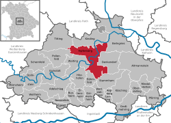 | ||
| Coordinates: 48°56′58″N 11°23′42″E / 48.94944°N 11.39500°ECoordinates: 48°56′58″N 11°23′42″E / 48.94944°N 11.39500°E | ||
| Country | Germany | |
| State | Bavaria | |
| Admin. region | Oberbayern | |
| District | Eichstätt | |
| Government | ||
| • Mayor | Rainer Richter (SPD) | |
| Area | ||
| • Total | 81.43 km2 (31.44 sq mi) | |
| Elevation | 378 m (1,240 ft) | |
| Population (2017-12-31)[1] | ||
| • Total | 5,797 | |
| • Density | 71/km2 (180/sq mi) | |
| Time zone | CET/CEST (UTC+1/+2) | |
| Postal codes | 85110 | |
| Dialling codes | 08465 | |
| Vehicle registration | EI | |
| Website | www.kipfenberg.de | |

Kipfenberg is a municipality in the district of Eichstätt in Bavaria in Germany. It is known for its famous hillside castle and fortress, as well as being the geographical centre of Bavaria. The river Altmühl flows through the market town.
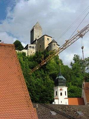
Burg Kipfenberg
Communities
| Community | Population |
| Kipfenberg | 1709 |
| Arnsberg | 325 |
| Attenzell | 241 |
| Biberg | 348 |
| Böhming | 599 |
| Buch | 174 |
| Dunsdorf | 188 |
| Grösdorf | 356 |
| Hirnstetten | 179 |
| Irlahüll | 250 |
| Kemathen | 036 |
| Krut | 065 |
| Oberemmendorf | 110 |
| Pfahldorf | 431 |
| Schambach | 060 |
| Schelldorf | 564 |
Kipfenberg
Mayors
| Years | Name | Party |
|---|---|---|
| –1996 | Christian Weiß | CSU |
| 1996–2014 | Rainer Richter | SPD |
| since 2014 | Christian Wagner | SPD |
References
- ↑ "Fortschreibung des Bevölkerungsstandes". Bayerisches Landesamt für Statistik und Datenverarbeitung (in German). September 2018.
![]()
This article is issued from
Wikipedia.
The text is licensed under Creative Commons - Attribution - Sharealike.
Additional terms may apply for the media files.