Neu-Ulm (district)
| Neu-Ulm | |
|---|---|
| District | |
 | |
| Country |
|
| State | Bavaria |
| Adm. region | Swabia |
| Capital | Neu-Ulm |
| Area | |
| • Total | 515 km2 (199 sq mi) |
| Population (31 December 2017)[1] | |
| • Total | 172,546 |
| • Density | 340/km2 (870/sq mi) |
| Time zone | UTC+01:00 (CET) |
| • Summer (DST) | UTC+02:00 (CEST) |
| Vehicle registration | NU |
| Website | landkreis.neu-ulm.de |
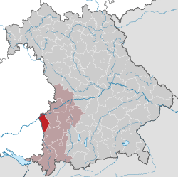
Neu-Ulm is a Landkreis (district) in Swabia, Bavaria, Germany. It is bounded by (from the east and clockwise) the districts of Günzburg and Unterallgäu and the state of Baden-Württemberg (districts Biberach and Alb-Donau, city of Ulm).
The district was established in 1972 by merging the former districts of Neu-Ulm and Illertissen with the previously district-free city of Neu-Ulm.
The district includes the eastern metropolitan area of the city of Ulm. The Danube and its tributary, the Iller, form the western border of the district.
Coat of arms
The coat of arms displays:
|
Towns and municipalities
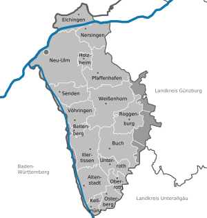
Towns and municipalities in Landkreis Neu-Ulm
| Towns | Municipalities | |
|---|---|---|
References
- ↑ "Fortschreibung des Bevölkerungsstandes". Bayerisches Landesamt für Statistik und Datenverarbeitung (in German). September 2018.
External links
| Wikimedia Commons has media related to Landkreis Neu-Ulm. |
- Official website (German)
Towns and municipalities in Neu-Ulm (district) | ||
|---|---|---|
This article is issued from
Wikipedia.
The text is licensed under Creative Commons - Attribution - Sharealike.
Additional terms may apply for the media files.