Neustadt an der Waldnaab (district)
| Neustadt an der Waldnaab | ||
|---|---|---|
| District | ||
| ||
 | ||
| Country |
| |
| State | Bavaria | |
| Adm. region | Upper Palatinate | |
| Capital | Neustadt an der Waldnaab | |
| Area | ||
| • Total | 1,430 km2 (550 sq mi) | |
| Population (31 December 2017)[1] | ||
| • Total | 94,486 | |
| • Density | 66/km2 (170/sq mi) | |
| Time zone | UTC+01:00 (CET) | |
| • Summer (DST) | UTC+02:00 (CEST) | |
| Vehicle registration | NEW | |
| Website | www.neustadt.de | |
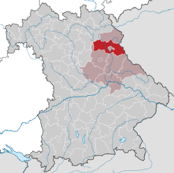
Neustadt an der Waldnaab is a Landkreis (district) in Bavaria, Germany. It is bounded by (from the south and clockwise) the districts of Schwandorf, Amberg-Sulzbach, Bayreuth and Tirschenreuth, and by the Czech Republic (Plzeň Region). The city of Weiden in der Oberpfalz is enclosed by, but not belonging to the district.
History
The district was established in 1972 by merging the former districts of Neustadt an der Waldnaab, Eschenbach and Vohenstrauß.
Geography
The district is located in the mountains of the Upper Palatine Forest (Oberpfälzer Wald). The two headstreams of the River Naab, the Waldnaab and Haidenaab, both run through the district to merge in the south of the area.
Coat of arms
 |
The coat of arms displays:
|
Towns and municipalities
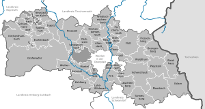
Towns and municipalities in Landkreis Neustadt an der Waldnaab
| Towns | Municipalities | |
|---|---|---|
References
- ↑ "Fortschreibung des Bevölkerungsstandes". Bayerisches Landesamt für Statistik und Datenverarbeitung (in German). September 2018.
External links
| Wikimedia Commons has media related to Landkreis Neustadt an der Waldnaab. |
- Official website (in German)
This article is issued from
Wikipedia.
The text is licensed under Creative Commons - Attribution - Sharealike.
Additional terms may apply for the media files.