Regen (district)
| Regen | |
|---|---|
| District | |
 | |
| Country |
|
| State | Bavaria |
| Adm. region | Lower Bavaria |
| Capital | Regen |
| Government | |
| • District admin. | Rita Röhrl (SPD) |
| Area | |
| • Total | 975 km2 (376 sq mi) |
| Population (31 December 2017)[1] | |
| • Total | 77,489 |
| • Density | 79/km2 (210/sq mi) |
| Time zone | UTC+01:00 (CET) |
| • Summer (DST) | UTC+02:00 (CEST) |
| Vehicle registration | REG |
| Website | landkreis-regen.de |
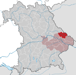
Regen is a Landkreis (district) in Bavaria, Germany. It is bounded by (from the south and clockwise) the districts of Freyung-Grafenau, Deggendorf, Straubing-Bogen and Cham, and by the Czech Republic (Plzeň Region).
History
The district was established in 1972 by merging the former districts of Regen and Viechtach.
Geography
The district is entirely located in the Bavarian Forest. It is named after the Regen river and its two headstreams, the Black Regen and the White Regen.
Coat of arms
 |
The coat of arms displays:
|
Towns and municipalities

Towns and municipalities in Landkreis Regen
| Towns | Municipalities | |
|---|---|---|
References
- ↑ "Fortschreibung des Bevölkerungsstandes". Bayerisches Landesamt für Statistik und Datenverarbeitung (in German). September 2018.
External links
| Wikimedia Commons has media related to Landkreis Regen. |
- Official website (German)
Towns and municipalities in Regen (district) | ||
|---|---|---|
This article is issued from
Wikipedia.
The text is licensed under Creative Commons - Attribution - Sharealike.
Additional terms may apply for the media files.