Pfaffenhofen (district)
| Pfaffenhofen | |
|---|---|
| District | |
 | |
| Country |
|
| State | Bavaria |
| Adm. region | Upper Bavaria |
| Capital | Pfaffenhofen an der Ilm |
| Area | |
| • Total | 760 km2 (290 sq mi) |
| Population (31 December 2017)[1] | |
| • Total | 126,244 |
| • Density | 170/km2 (430/sq mi) |
| Time zone | UTC+01:00 (CET) |
| • Summer (DST) | UTC+02:00 (CEST) |
| Vehicle registration | PAF |
| Website | landkreis-pfaffenhofen.de |
![]()
History
In early medieval times the region was partially property of the powerful monasteries of Ilmmünster and Münchsmünster, and partially divided into tiny secular states. One of those states was the county of Scheyern. The counts were ancestors of the Wittelsbach family, who in 1180 became rulers of Bavaria. From that time on the region was a part of Bavaria.
The district of Pfaffenhofen was established in 1972 by merging several former districts.
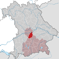
Geography
The district is located in the Hallertau Plains between the Isar and Danube rivers. The Danube crosses the northernmost part of the district.
Coat of arms
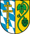 |
The coat of arms displays:
|
Towns and municipalities

Towns
Municipalities
International cooperation
These are the official sister cities
| Country | City | County / District / Region / State | |
|---|---|---|---|
| Serbia | Valjevo | Kolubara District | |
References
- ↑ "Fortschreibung des Bevölkerungsstandes". Bayerisches Landesamt für Statistik und Datenverarbeitung (in German). September 2018.
External links
| Wikimedia Commons has media related to Landkreis Pfaffenhofen a.d.Ilm. |
- Official website (German)
Towns and municipalities in Pfaffenhofen | ||
|---|---|---|
Coordinates: 48°30′N 11°30′E / 48.5°N 11.5°E
| Authority control |
|---|