Dunmore, Pennsylvania
| Dunmore | |
|---|---|
| Borough | |
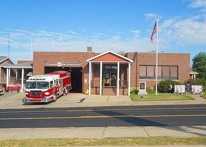 Municipal building | |
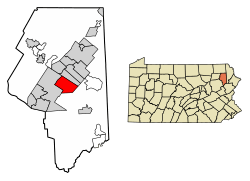 Location of Dunmore in Lackawanna County, Pennsylvania. | |
 Dunmore Location of Dunmore in Pennsylvania  Dunmore Dunmore (the US) | |
| Coordinates: 41°25′03″N 75°37′28″W / 41.41750°N 75.62444°WCoordinates: 41°25′03″N 75°37′28″W / 41.41750°N 75.62444°W | |
| Country | United States |
| State | Pennsylvania |
| County | Lackawanna |
| Government | |
| • Mayor | Timothy Burke (D) |
| Area[1] | |
| • Total | 8.99 sq mi (23.30 km2) |
| • Land | 8.92 sq mi (23.10 km2) |
| • Water | 0.08 sq mi (0.20 km2) |
| Elevation | 1,001 ft (305 m) |
| Population (2010) | |
| • Total | 14,057 |
| • Estimate (2016)[2] | 13,187 |
| • Density | 1,478.69/sq mi (570.93/km2) |
| Time zone | UTC-5 (EST) |
| • Summer (DST) | UTC-4 (EDT) |
| Zip Code | 18512 |
| Area code(s) | 570 |
| Website | http://www.dunmorepa.gov |
Dunmore is a borough in Lackawanna County, Pennsylvania, adjoining Scranton. Dunmore was settled in 1835 and incorporated in 1862. Extensive anthracite coal, brick, stone, and silk interests had led to a rapid increase in the population from 8,315 in 1890 to 23,086 in 1940. The population was 14,057 at the 2010 census.
History
Dunmore is one of the numerous villages which sprang from the original township of Providence, Pennsylvania. The territory now encompassing this borough was purchased from the natives in 1754.
In 1783, William Allsworth, a shoemaker by trade, who had visited the Connecticut land at Wyoming for the purpose of selecting a place for his home the year before, reached the point at evening, where he encamped and lit his fire in the forest where Dunmore was founded. The need for more places of rest for travelers caused Mr. Allsworth to build his home at this spot. The house of Mr. Allsworth became a common point of interest and attraction to travelers.
In the summer of 1795, Charles Dolph, John Carey, and John West began the labor of clearing and plowing lands in the neighborhood of Bucktown or Corners, as this area was long called after the first foot-path from Blakeley to the Roaring Brook crossed the Wyoming road at Allsworth’s.
Edward Lunnon, Isaac Dolph, James Brown, Philip Swartz and Levi De Puy, purchased land of the State between 1799–1805 and located in this portion of Providence Township. The old tavern was owned successively by Wm. Allsworth, Philip Swartz, Isaac Dolph, Henry W. Drinker, and Samuel De Puy.
The external aspect of Dunmore promised so much by its agricultural expectations in 1813, that Dr. Orlo Hamlin, with his young wife, was induced to settle a mile north of Allsworth. He was the first physician and surgeon in Providence. The population of Dunmore and Blakeley, doubling in numbers and increasing in wealth, warranted Stephen Tripp in erecting a saw and grist mill in 1820, on the Roaring Brook half a mile south of the village.
A store was opened at the Corners in 1820 under the auspices of the Drinker Turnpike company; but the village, consisting of but four houses, had a negative existence until the Pennsylvania Coal Company, in 1847-1848, turned it into a growing and diverse town.[3]
By 1875, the township of Providence was dissolved and the land split up into various smaller boroughs and towns with Dunmore being one of them. Today, Dunmore is a borough bordering the city of Scranton.
The name Dunmore comes from Dunmore Park, in the Falkirk area of Scotland (home of the Dunmore Pineapple).
Geography
Dunmore is located at 41°25′3″N 75°37′28″W / 41.41750°N 75.62444°W (41.417530, -75.624432).[4]
According to the United States Census Bureau, the borough has a total area of 9 square miles (23 km2), of which, 8.9 square miles (23 km2) of it is land and 0.1 square miles (0.26 km2) of it (1.11%) is water.
Roaring Brook flows from the southeast and turns west through the Nay Aug Gorge in Dunmore to the Lackawanna River in Scranton. Most of the borough is drained by Roaring Brook, except for an area in the west drained by Meadow Brook into the Lackawanna River. The southeast side of the borough is on the slopes of the Moosic Mountains,[5] which the gorge cuts through.
The western terminus of Interstate 84 is in Dunmore. I-84/I-380 follows the Nay Aug Gorge westward towards the spaghetti junction interchange with Interstate 81 and U.S. Route 6. I-81 also has an interchange with 347 in Dunmore.
The Lackawanna Railroad operated through the Nay Aug Gorge into Scranton from the Poconos and Northern New Jersey.
Places adjacent to Dunmore, Pennsylvania | |
|---|---|
Demographics
| Historical population | |||
|---|---|---|---|
| Census | Pop. | %± | |
| 1870 | 4,311 | — | |
| 1880 | 5,151 | 19.5% | |
| 1890 | 8,315 | 61.4% | |
| 1900 | 12,583 | 51.3% | |
| 1910 | 17,615 | 40.0% | |
| 1920 | 20,250 | 15.0% | |
| 1930 | 22,627 | 11.7% | |
| 1940 | 23,086 | 2.0% | |
| 1950 | 20,305 | −12.0% | |
| 1960 | 18,917 | −6.8% | |
| 1970 | 18,168 | −4.0% | |
| 1980 | 16,781 | −7.6% | |
| 1990 | 15,403 | −8.2% | |
| 2000 | 14,018 | −9.0% | |
| 2010 | 14,057 | 0.3% | |
| Est. 2016 | 13,187 | [2] | −6.2% |
| Sources:[6][7][8][9] | |||
As of the 2010 United States Census, there were 14,057 people, 5,999 households, and 3,388 families residing in the borough.[10] The population density was 1,579.4 people per square mile (610/km²). There were 6,530 housing units at an average density of 733.7 per square mile (286.6/km²). The racial makeup of the borough was 95.2% White, 1.1% African American, 0.05% Native American, 1.8% Asian, 0.05% Pacific Islander, 0.8% from other races, and 1% from two or more races. Hispanic or Latino of any race were 2.3% of the population.
There were 5,999 households, out of which 22% had children under the age of 18 living with them, 40.6% were married couples living together, 11.5% had a female householder with no husband present, and 43.5% were non-families. 37.9% of all households were made up of individuals, and 16% had someone living alone who was 65 years of age or older. The average household size was 2.18 and the average family size was 2.93.
The ages of the population were 17.9% under the age of 18, 62.1% from 18 to 64, and 20% 65 years or older. The median age was 42.1 years.
The median income for a household in the borough was $33,280, and the median income for a family was $43,354. Males had a median income of $32,855 versus $24,167 for females. The per capita income for the borough was $19,851. About 6.7% of families and 10.5% of the population were below the poverty line, including 11.1% of those under age 18 and 11.8% of those age 65 or over.
Economy
Gertrude Hawk Chocolates, founded in 1936, is based in Dunmore. Golo Footwear had its original manufacturing and design facilities in Dunmore until 1957.
Environmental issues
Keystone Sanitary Landfill, the largest landfill in the state of Pennsylvania has been located in Dunmore since 1973,[11] about 450 feet from the Dunmore Reservoir #1, a backup drinking water supply. In 1987, it extended to Throop, Pennsylvania.[12] The landfill was built over mines known for ground subsidence. As of 2015 the landfill accepts over 7,200 tons of trash per day.[13] More than a third of its in-state waste since 2009 is from fracking drill cuttings, drilling mud and fluids. Cuttings are mixed with small amounts of naturally occurring radioactive elements, particularly radium-226.[14] The landfill has been leaking into ground water per its Phase 3 permit application. Run-off is discharged into Eddy’s Creek and the Lackawanna River.
In November 2014, the Dunmore borough council approved a $15.63 million agreement for Keystone as a basis for an extension, and a definition of the landfill as a “pre-existing landfill” to ensure Keystone a more favorable interpretation of the borough’s zoning ordinance against public opinion.[15]
Infrastructure
Dunmore has four schools, Dunmore High School, Holy Cross High School (formerly known as Bishop O'Hara High School), Dunmore Elementary Center, and Saint Mary's of Mount Carmel Elementary School.
Notable people
- Mehmood Ali (1932-2004), actor, "India's Comedy King", died in Dunmore
- Sister M. Adrian Barrett, I.H.M. (1929–2015), Catholic social worker and educator
- Christopher F. Burne, a U.S. Air Force Brigadier General
- Nestor Chylak (1922-1982), Major League Baseball umpire
- Vic Delmore (1917–1960), Major League Baseball umpire
- Carol Ann Drazba (1943-1966), first American nurse to die in Vietnam War
- Vic Fangio, defensive coordinator for Chicago Bears of National Football League
- Joe Mooney, Major League Baseball groundskeeper for more than three decades; Boston Red Sox Hall of Fame member
- John Willard Raught (1857-1931), landscape artist
- Paul W. Richards, astronaut who flew on Mission STS-102 on board The Space Shuttle Discovery
- John Francis Ropek (1917–2009), oceanographer for first under-ice Polar expedition of USS Nautilus (SSN-571)
- Tim Ruddy, center for NFL's Miami Dolphins from 1994-2003; for most of career was center of Pro Football Hall of Fame quarterback Dan Marino
- Junior Walsh (1919-1990), professional baseball player for Pittsburgh Pirates
- Jerry Wemple (born 1960), poet
Gallery
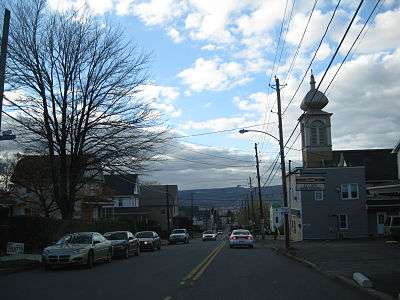 Drinker Street in Dunmore
- Dunmore fire station
See also
References
- ↑ "2016 U.S. Gazetteer Files". United States Census Bureau. Retrieved Aug 14, 2017.
- 1 2 "Population and Housing Unit Estimates". Retrieved June 9, 2017.
- ↑ O'Hora, Margaret M. (1937). History of Dunmore Pennsylvania. Dunmore, PA: Dunmore Improvement Association. pp. 7–9. Retrieved 22 April 2017.
- ↑ "US Gazetteer files: 2010, 2000, and 1990". United States Census Bureau. 2011-02-12. Retrieved 2011-04-23.
- ↑ O'Hora, Margaret M. (1937). History of Dunmore Pennsylvania. Dunmore, PA: Dunmore Improvement Association. p. 5. Retrieved 22 April 2017.
- ↑ "Number of Inhabitants: Pennsylvania" (PDF). 18th Census of the United States. U.S. Census Bureau. Retrieved 22 November 2013.
- ↑ "Pennsylvania: Population and Housing Unit Counts" (PDF). U.S. Census Bureau. Retrieved 22 November 2013.
- ↑ "American FactFinder". United States Census Bureau. Archived from the original on 2013-09-11. Retrieved 2008-01-31.
- ↑ "Annual Estimates of the Resident Population". U.S. Census Bureau. Retrieved 22 November 2013.
- ↑ "American FactFinder". United States Census Bureau. Archived from the original on 2013-09-11. Retrieved 2011-05-14.
- ↑ A timeline of events Friends of Lackawanna.org, undated, retrieved 8 October 2015
- ↑ 1045 Sharon Soltis-Sparano Pennsylvania State Ethics Commission, page 33 of 39, 20 February 1997
- ↑ The facts Friends of Lackawanna.org, undated, retrieved 8 October 2015
- ↑ Keystone landfill now allowed to receive waste drilling fluid. Times Leader, 9 June 2015
- ↑ Brendan Gibbons Dunmore approves Keystone landfill agreement, The Scranton Times-Tribune, November 25, 2014.
External links

- Borough of Dunmore
Municipalities and communities of Lackawanna County, Pennsylvania, United States | ||
|---|---|---|
| Cities |  | |
| Boroughs | ||
| Townships | ||
| CDPs | ||
| Unincorporated communities |
| |