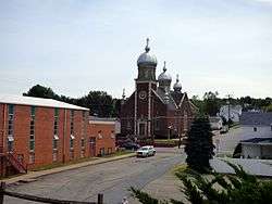
Jermyn, Pennsylvania
| Borough of Jermyn | |
|---|---|
 | |
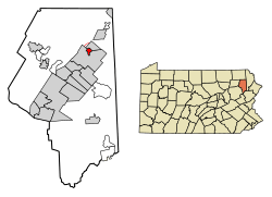 Location of Jermyn in Lackawanna County, Pennsylvania. | |
 Jermyn Location of Jermyn in Pennsylvania  Jermyn Jermyn (the US) | |
| Coordinates: 41°31′40″N 75°32′50″W / 41.52778°N 75.54722°WCoordinates: 41°31′40″N 75°32′50″W / 41.52778°N 75.54722°W | |
| Country | United States |
| State | Pennsylvania |
| County | Lackawanna |
| Government | |
| • Mayor | Anthony Fuga Jr |
| Area[1] | |
| • Total | 0.79 sq mi (2.05 km2) |
| • Land | 0.79 sq mi (2.05 km2) |
| • Water | 0.00 sq mi (0.00 km2) |
| Elevation | 971 ft (296 m) |
| Population (2010) | |
| • Total | 2,169 |
| • Estimate (2016)[2] | 2,079 |
| • Density | 2,625.00/sq mi (1,013.05/km2) |
| Time zone | UTC-5 (EST) |
| • Summer (DST) | UTC-4 (EDT) |
| Area code(s) | 570 Exchange: 876 |
| FIPS code | 42-38096 |
| Website |
jermynpa |
Jermyn, known as "The Birthplace of First Aid in America," is a borough in Lackawanna County, Pennsylvania, on the Lackawanna River, 12 miles (19 km) northeast of Scranton. A productive anthracite coal field was in the region in 1900 when 2,567 people lived here. In 1910, 3,158 residents of Jermyn were tallied. In the early years of the twentieth century, coal mines, cut-glass works, silk, powder, grist, planing, and saw mills, bottling works, and fertilizer factories dotted the borough. The population was 2,169 at the 2010 census. Jermyn is the mailing address of the Lakeland School District. The section of town east of the Lackawanna River and west of the small section of Archbald known as "Nebraska", East Jermyn is commonly referred to as "Calico Lane" or "The Lane". Jermyn was incorporated as a borough in 1870 and celebrated its Centennial in 1970 with a week-long celebration.
History
The borough was named for John Jermyn, a businessperson in the mining industry.[3]
Geography
Jermyn is located at 41°31′40″N 75°32′50″W / 41.52778°N 75.54722°W (41.527806, -75.547147).[4]
According to the United States Census Bureau, the borough has a total area of 0.8 square miles (2.1 km2), all of it land.
Demographics
| Historical population | |||
|---|---|---|---|
| Census | Pop. | %± | |
| 1880 | 1,541 | — | |
| 1890 | 2,650 | 72.0% | |
| 1900 | 2,567 | −3.1% | |
| 1910 | 3,158 | 23.0% | |
| 1920 | 3,326 | 5.3% | |
| 1930 | 3,519 | 5.8% | |
| 1940 | 3,238 | −8.0% | |
| 1950 | 2,535 | −21.7% | |
| 1960 | 2,568 | 1.3% | |
| 1970 | 2,435 | −5.2% | |
| 1980 | 2,411 | −1.0% | |
| 1990 | 2,263 | −6.1% | |
| 2000 | 2,287 | 1.1% | |
| 2010 | 2,169 | −5.2% | |
| Est. 2016 | 2,079 | [2] | −4.1% |
| Sources:[5][6][7] | |||
As of the census[8] of 2010, there were 2,169 people, 951 households, and 581 families residing in the borough. The population density was 2,711.3 people per square mile (1,046.8/km²). There were 1,017 housing units at an average density of 1,271.3 per square mile (496.6/km²). The racial makeup of the borough was 96.8% White, 1.1% African American, 0.3% Native American, 0.4% Asian, 0.6% from other races, and 0.8% from two or more races. Hispanic or Latino of any race were 2.1% of the population.
There were 951 households, out of which 24.1% had children under the age of 18 living with them, 43% were married couples living together, 13.6% had a female householder with no husband present, and 38.9% were non-families. 32.3% of all households were made up of individuals, and 11.6% had someone living alone who was 65 years of age or older. The average household size was 2.27 and the average family size was 2.87.
In the borough the population was spread out, with 20.4% under the age of 18, 61.7% from 18 to 64, and 17.9% who were 65 years of age or older. The median age was 42.1 years.
The median income for a household in the borough was $32,824, and the median income for a family was $39,740. Males had a median income of $29,063 versus $23,580 for females. The per capita income for the borough was $17,417. About 8.9% of families and 12.7% of the population were below the poverty line, including 19.3% of those under age 18 and 13.4% of those age 65 or over.
References
- ↑ "2016 U.S. Gazetteer Files". United States Census Bureau. Retrieved Aug 14, 2017.
- 1 2 "Population and Housing Unit Estimates". Retrieved June 9, 2017.
- ↑ Hollister, Horace (1885). History of the Lackawanna Valley. Lippincott. p. 490.
- ↑ "US Gazetteer files: 2010, 2000, and 1990". United States Census Bureau. 2011-02-12. Retrieved 2011-04-23.
- ↑ "Census of Population and Housing". U.S. Census Bureau. Archived from the original on 12 May 2015. Retrieved 11 December 2013.
- ↑ "American FactFinder". United States Census Bureau. Retrieved 2008-01-31.
- ↑ "Incorporated Places and Minor Civil Divisions Datasets: Subcounty Resident Population Estimates: April 1, 2010 to July 1, 2012". Population Estimates. U.S. Census Bureau. Archived from the original on 17 June 2013. Retrieved 11 December 2013.
- ↑ "American FactFinder". United States Census Bureau. Retrieved 2011-05-14.
External links
Municipalities and communities of Lackawanna County, Pennsylvania, United States | ||
|---|---|---|
| Cities | 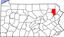 | |
| Boroughs | ||
| Townships | ||
| CDPs | ||
| Unincorporated communities |
| |