Malipo County
| Malipo County 麻栗坡县 | |
|---|---|
| County | |
.png) Location of Malipo County (pink) and Wenshan Prefecture (yellow) within Yunnan province of China | |
| Country | People's Republic of China |
| Province | Yunnan |
| Autonomous prefecture | Wenshan |
| Area | |
| • Total | 2,395 km2 (925 sq mi) |
| Population | |
| • Total | 270,000 |
| • Density | 110/km2 (290/sq mi) |
| Time zone | UTC+8 (CST) |
| Postal code | 663600 |
| Area code(s) | 0876 |
| Website | http://www.ynmlp.gov.cn/ |
.jpg)
Emerald crystals, Dayakou emerald mine, Malipo County
Malipo County (Chinese: 麻栗坡县; pinyin: Málìpō Xiàn, Vietnamese: Ma Lật Pha) is under the administration of the Wenshan Zhuang and Miao Autonomous Prefecture, in the southeast of Yunnan province, China, bordering Ha Giang Province to the southeast.
Ethnic groups
The following list of ethnic groups and subgroups, and their respective distributions, is from the Malipo County Almanac (2000).
- Han: 152,407 people (1990)
- Zhuang: 30,706 people (1990)
- Miao: 41,620 people (1990)
- White Miao 白苗 (autonym: Mengdou 蒙逗): Donggan, Xinzhai, Majie, Tiechang
- Flowery Miao 花苗 (autonyms: Mengcai 蒙彩, Mengleng 蒙冷, Mengshe 蒙舍): Malipo Town, Daping, Mengdong, Nanwenhe, Xiajinchang, Babu, Liuhe, Yangwan
- Black Miao 黑苗 (autonym: Mengduo 蒙夺): Dongyou 东油,[1] Jiangdong 江东[2] of Babu Township 八布乡
- Green Miao 青苗 (autonym: Mengzhao 蒙诏): Chonggan 铳干,[3] Yangwan Township 杨万乡 and Tanshan 炭山,[4] Babu Township 八布乡
- Yao: 17,925 people (1990)
- Landian [Blue Indigo] Yao 蓝靛瑶 (autonyms: Men 门, Jinmen 金门)
- Horned Yao 角瑶 (autonym: You Mian 尤棉)
- Yi: 5,212 people (1990)
- White Luo 白倮, also Hairy Lolo 毛倮倮 due to their long hair (autonym: Muyasang 木亚桑): Xinzhai 新寨[5] and Chengzhai 城寨[6][7] villages of Xinzhai Township 新寨乡; entered Malipo County during the Qing Dynasty
- Flowery Luo 花倮, formerly Head-Cutting Luo 砍头倮 (autonyms: Muji 木吉, Egao 呃稿): Mabeng 马崩,[8] Yongli 永利,[9] and Zhelong 者挖[10] villages of Donggan Township 董干镇; entered the Donggan area at the end of the Ming Dynasty and beginning of the Qing Dynasty
- Mengwu 孟武: Mada Village 马达,[11] Daping Township 大坪镇; entered Malipo County at the end of the Ming Dynasty and beginning of the Qing Dynasty
- Pubiao 普标, historically Woni 窝泥, and Pubiao Lolo 普标倮倮 during the Republic of China era (autonym: Geibiao 给标): Punong 普弄,[12] Pufeng 普峰, Longlong 竜/龙龙,[13] and other villages. Their ancestors were reported to have migrated from a location called Dayandong 大岩洞 in Pumei 普梅 or gə33 mei33[14](also called Puyang 普阳 or gə33 wan55[14]).
- Laji 拉基: Maoping 茅坪, Yuhuang 玉皇; Nanwenhe Township 南温河乡, where they were one of the earliest inhabitants; entered Malipo County at the end of the Ming Dynasty and beginning of the Qing Dynasty from a place called Amizhou 阿迷州
- Dai: 2,664 people (1990), mostly in Nanwenhe Township 南温河乡
- Gelao: 1,166 people (1990); entered Malipo County at the end of the Ming Dynasty and beginning of the Qing Dynasty from Guizhou and Guangnan County
- White Gelao 白仡佬
- Flowery Gelao 花仡佬
- Green/Bamboo Gelao 青/箐仡佬
- Mongol: 1,211 people (1990)
Tourism
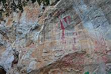
Neolithic painting at the 'Great King' painting site above Malipo in Wenshan prefecture, Yunnan province, China.
One major tourist attraction is the neolithic rock art above Malipo itself, apparently known as the 'Great King' site for the two dominant figures at the center of the artwork. It is said to be over 4000 years old.[15]
Transport
- Nearest airport: Wenshan Airport
References
- ↑ "麻栗坡县八布乡东油村委会". Ynszxc.gov.cn. Retrieved 15 August 2018.
- ↑ "麻栗坡县八布乡江东村委会". Ynszxc.gov.cn. Retrieved 15 August 2018.
- ↑ "麻栗坡县杨万乡杨万村委会铳干自然村". Ynszxc.gov.cn. Retrieved 15 August 2018.
- ↑ "麻栗坡县八布乡龙龙村委会炭山一组自然村". Ynszxc.gov.cn. Retrieved 15 August 2018.
- ↑ "麻栗坡县董干镇新寨村委会新寨自然村". Ynszxc.gov.cn. Retrieved 15 August 2018.
- ↑ "麻栗坡县董干镇新寨村委会城寨自然村". Ynszxc.gov.cn. Retrieved 15 August 2018.
- ↑
- ↑ "麻栗坡县董干镇马崩村委会". Ynszxc.gov.cn. Retrieved 15 August 2018.
- ↑ "麻栗坡县董干镇永利村委会". Ynszxc.gov.cn. Retrieved 15 August 2018.
- ↑ "麻栗坡县董干镇者挖村委会". Ynszxc.gov.cn. Retrieved 15 August 2018.
- ↑ "麻栗坡县大坪镇马达村委会". Ynszxc.gov.cn. Retrieved 15 August 2018.
- ↑ "麻栗坡县董干镇普弄村委会". Ynszxc.gov.cn. Retrieved 15 August 2018.
- ↑ "麻栗坡县八布乡龙龙村委会". Ynszxc.gov.cn. Retrieved 15 August 2018.
- 1 2 Liang Min, Zhang Junru & Li Yunbing (2007). Pubiao yu yanjiu. Beijing: The Ethnic Publishing House.
- ↑ "麻栗坡大王岩崖画-《风景名胜》1998年11期-中国知网". Mall.cnki.net. Retrieved 15 August 2018.
External links
| Wikimedia Commons has media related to Minerals of Dayakou. |
Coordinates: 23°07′32″N 104°42′11″E / 23.12556°N 104.70306°E
This article is issued from
Wikipedia.
The text is licensed under Creative Commons - Attribution - Sharealike.
Additional terms may apply for the media files.